geo.wikisort.org - Reservoir
Ammersee (English: Lake Ammer) is a Zungenbecken lake in Upper Bavaria, Germany, southwest of Munich between the towns of Herrsching and Dießen am Ammersee. With a surface area of approximately 47 square kilometres (18 sq mi), it is the sixth largest lake in Germany. The lake is at an elevation of 533 metres (1,749 ft), and has a maximum depth of 81 metres (266 ft). Like other Bavarian lakes, Ammersee developed as a result of the ice age glaciers melting. Ammersee is fed by the River Ammer, which flows as the Amper out of the lake. Like neighbouring Lake Starnberg - deeper, bigger in surface area, similar in shape - it is a popular location for watersports.
| Ammersee Lake Ammer | |
|---|---|
 Aerial view of the Ammersee from the south | |
 Ammersee Lake Ammer | |
| Location | Upper Bavaria |
| Coordinates | 48°00′N 11°07′E |
| Primary inflows | River Ammer |
| Primary outflows | Amper |
| Catchment area | 993.0 km2 (383.4 sq mi) |
| Basin countries | Germany |
| Max. length | 16.2 km (10.1 mi) |
| Max. width | 5 km (3.1 mi) |
| Surface area | 46.6 km2 (18.0 sq mi) |
| Average depth | 37.8 m (124 ft) |
| Max. depth | 81 m (266 ft) |
| Residence time | 2.7 years |
| Surface elevation | 533 m (1,749 ft) |
| Islands | Schwedeninsel |
| Settlements | Herrsching, Dießen am Ammersee, Schondorf, Breitbrunn, Utting, Buch, Riederau, Eching, Inning |
Ramsar Wetland | |
| Designated | 26 February 1976 |
| Reference no. | 93[1] |
Ammersee and the Amper are part of the ancient Celtic amber trading route leading to the Brenner Pass. The word Ammer is a 13th-century form of Amper, the Celtic *ambra, deriving from the Indo-European *ombh-, *mbh- "wet, Water".[2]
Passenger services have operated on the lake since 1879. Today they are operated by the Bayerische Seenschifffahrt company, using a mixture of historic paddle steamers and motor ships.[3][4]
Ecology, biology and conservation
The water quality, which was endangered in the sixties of the 20th century, was significantly improved by comprehensive wastewater remediation measures such as the construction of a ring main, the commissioning of the sewage treatment plant in Eching in 1971 and the rehabilitation of the sewage treatment plants in the Ammer catchment area. Further information on the history and development of the Eching wastewater treatment plant is provided by AWA-Ammersee, which manages drinking water and wastewater in the region. Since the mid-1980s, the nutrient load of the water has shifted from the eutrophic to the mesotrophic range, which means that the nutrient load is low to moderate, the production of algae is moderate, and the average visual depth is over 2 m. The use of the Ammersee as a bathing water is thus secured in the long term.
Among the fish living in the lake, an endemic whitefish (Coregonus bavaricus) is known, a whitefish species mainly found in the pre-Alpine lakes, whose occurrence has led to a long tradition of quite intensive fishing exploitation of the lake. The lake is also home of the vulnerable species of deepwater char Salvelinus evasus.[5] Deepwater char are highly sensitive to changes in the quality of the water and some species such as Salvelinus neocomensis and Salvelinus profundus were driven recently to extinction in other European lakes.[6] In 2010, even a new species of fish, the Ammersee Kaulbarsch (Gymnocephalus ambriaelacus),[7] which is also found only in the Ammersee, was described.
With the nature reserves Vogelfreistätte Ammersee-Südufer (in which the Schwedeninsel is also located), Seeholz and Seewiese as well as Ampermoos, the Ammersee is one of the seven internationally important wetlands in Bavaria according to the so-called Ramsar Convention. On the western shore, access to the shore is closed to the general public except for short stretches, but almost the entire eastern shore is open to the public. Large areas of the shore are still in a near-natural state, but the formerly dense reed beds have decreased significantly since the end of the 1960s. In contrast, microplastic pollution has increased.[8]
Gallery
 Eastern shore
 Autumn
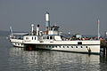 Paddle Steamer Diessen on the lake
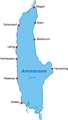 Map of lake with settlements and deepest point marked
 Ice on the Ammersee (2006)


References
- "Ammersee". Ramsar Sites Information Service. Retrieved 25 April 2018.
- Dieter Berger: Duden - Geographische Namen in Deutschland. 2nd ed., Dudenverlag, 1999, ISBN 978-3-411-06252-2.
- "Bayerische Seenschifffahrt". Bayerische Seenschifffahrt. Archived from the original on 2011-07-16. Retrieved 11 July 2011.
- "Geschichtliche Hintergründe" [Historical Background] (in German). Bayerische Seenschifffahrt. Archived from the original on 10 December 2011. Retrieved 11 July 2011.
- Revue Suisse de Zoologie - Salvelinus evasus[permanent dead link]; accessed 24 January 2018.
- "Red List - Volume 1: Vertebrates (2009) - General assessment for the vertebrate groups". Archived from the original on 2013-06-23. Retrieved 2012-12-29.
- Matthias F. Geiger und Ulrich K. Schliewen: Gymnocephalus ambriaelacus, a new species of ruffe from Lake Ammersee, southern Germany (Teleostei, Perciformes, Percidae). Spixiana, 33, S. 119–137, 2010
- Martin Müller: Forscher finden jede Menge Mikroplastik in bayerischen Seen. In: nordbayern.de. 29 October 2019, retrieved 29 October 2019.
External links
 Media related to Ammersee at Wikimedia Commons
- Nixdorf, B.; et al. (2004), "Ammersee", Dokumentation von Zustand und Entwicklung der wichtigsten Seen Deutschlands (in German), Berlin: Umweltbundesamt, p. 8
- Pictures of the Ammersee
Authority control | |
|---|---|
| General |
|
| National libraries | |
| Other | |
На других языках
[de] Ammersee
Der Ammersee ist nach dem Chiemsee und dem Starnberger See der drittgrößte See in Bayern (unter den Seen, die ausschließlich in Bayern liegen) und der am weitesten nach Norden reichende Voralpensee. Häufig wird er auch als ländlich geprägter „Bauernsee“ im Gegensatz zum vornehmeren „Fürstensee“ (Starnberger See) bezeichnet.[2] Er zählt zum gleichnamigen gemeindefreien Gebiet Ammersee mit den Gemeinden am Westufer zum Landkreis Landsberg am Lech. Das Ostufer gehört zu verschiedenen Gemeinden im Landkreis Starnberg, sowie ein kleiner Teil im Süden um die Mündung der Ammer zum Landkreis Weilheim-Schongau. Der See ist Eigentum des Freistaates Bayern, für dessen Verwaltung die Bayerische Verwaltung der staatlichen Schlösser, Gärten und Seen zuständig ist.[3] Der See hat eine Fläche von rund 47 Quadratkilometern und eine maximale Tiefe von etwa 80 Metern. Die am südlichen Seeende gelegene Schwedeninsel ist durch die fortschreitende Verlandung schon zu einer Halbinsel geworden und wird irgendwann ganz mit dem Ufer verschmelzen.- [en] Ammersee
[es] Lago Ammer
El lago Ammer (en alemán: Ammersee) es un lago en la Alta Baviera, Alemania, ubicado al suroeste de Múnich entre las ciudades de Herrsching y Dießen am Ammersee. Con una superficie de aproximadamente 47 km², es el sexto lago por tamaño de Alemania. Se encuentra a una altitud de 520 m s. n. m. y tiene una profundidad máxima de 81 metros. Como otros lagos bávaros, el lago Ammer se desarrolló como consecuencia del deshielo de los glaciares de la Edad de Hielo. El lago Ammer está alimentado por el río Ammer que fluye como Amper fuera del lago. Como el vecino lago de Starnberg, que es parecido en forma y tamaño, es un lugar popular para los deportes acuáticos.[fr] Lac Ammer
Le lac Ammer, ou Ammersee en allemand, est un grand lac en Haute-Bavière, au sud-ouest de Munich, entre les villes d'Herrsching,de Dießen am Ammersee et d'Inning am Ammersee.[it] Ammersee
L'Ammersee è un lago dell'Alta Algovia ed è il terzo lago in ordine di grandezza della Baviera (ed il sesto lago della Germania). Si trova a circa 35 km da Monaco di Baviera all'altitudine di circa 532,9 metri, ha una profondità massima di 81,1 metri e una superficie di 46,6 km².[ru] Аммерзе
А́ммерзе[1] (нем. Ammersee) — озеро, расположенное в Германии, в Баварии, в окрестностях Мюнхена, между городами Хершинг-ам-Аммерзе и Дисен-ам-Аммерзе.Другой контент может иметь иную лицензию. Перед использованием материалов сайта WikiSort.org внимательно изучите правила лицензирования конкретных элементов наполнения сайта.
WikiSort.org - проект по пересортировке и дополнению контента Википедии