geo.wikisort.org - Montagne
La Tour Ronde (3.798 m s.l.m.[1]) è una montagna del massiccio del Monte Bianco. Su di essa passa la linea di confine tra l'Italia e la Francia.
| Tour Ronde | |
|---|---|
 | |
| Stati | |
| Regione | Rodano-Alpi |
| Provincia | Alta Savoia |
| Altezza | 3 798 m s.l.m. |
| Prominenza | 165 m |
| Catena | Alpi |
| Coordinate | 45°50′42.51″N 6°54′23″E |
| Data prima ascensione | 22 luglio 1867 |
| Autore/i prima ascensione | J.H. Backhouse, T.H. Carson, Douglas William Freshfield, C.C. Tucker, Daniel Balleys e Michel Payot |
| Mappa di localizzazione | |
 Tour Ronde  | |
| Dati SOIUSA | |
| Grande Parte | Alpi Occidentali |
| Grande Settore | Alpi Nord-occidentali |
| Sezione | Alpi Graie |
| Sottosezione | Alpi del Monte Bianco |
| Supergruppo | Massiccio del Monte Bianco |
| Gruppo | Gruppo del Monte Bianco |
| Sottogruppo | Gruppo della Tour Ronde |
| Codice | I/B-7.V-B.2.f/a |
La montagna si trova lungo lo spartiacque che dal monte Maudit scende al colle del Gigante.
Ascensioni
Prima ascensione
La prima ascensione fu compiuta il 22 luglio 1867 da J.H. Backhouse, T.H. Carson, Douglas William Freshfield, C.C. Tucker, Daniel Balleys e Michel Payot.[2]
Via normale
La via normale sale lungo la cresta sud-est, partendo dal Rifugio Torino o dalla Punta Helbronner.
Vie alpinistiche
Parete nord
- Parete nord classica - 23 agosto 1886 - Prima salita di Francesco Gonella e Alexis Berthod.[3]
- Via Buscaini - 19 agosto 1959 - Prima salita di Gino Buscaini, in solitaria.[4]
- Via Bernezat - 17 giugno 1962 - Prima salita di Jean-Louis Bernezat e Christian Colomb, cresta nord-est.[3]
Parete nord-ovest
- Via Cordier - giugno 1977 - Prima salita di Patrick Cordier e un compagno.[5]
- Via Gabarrou-Ponti - 25 giugno 1978 - Prima salita di Patrick Gabarrou e René Ponti.[5]
Parete ovest
- Couloir Gervasutti - 27 luglio 1934 - Prima salita di Giusto Gervasutti e Renato Chabod, 350 m/AD.[6]
- Via Mollier-Payot - 23 luglio 1961 - Prima salita di Christian Mollier e Georges Payot.[7]
- Couloir Rébuffat - 31 luglio 1967 - Prima salita di Gaston Rébuffat e Robert Mazars.[5]
Discese in sci
- Parete nord classica - 20 giugno 1971 - Prima discesa di Patrick Vallençant.[4]
- Couloir Gervasutti - 31 marzo 1974 - Prima discesa di D.Chabod e Jean-Pierre Mansart.[6]
Galleria d'immagini
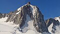 La parete nord della Tour Ronde.
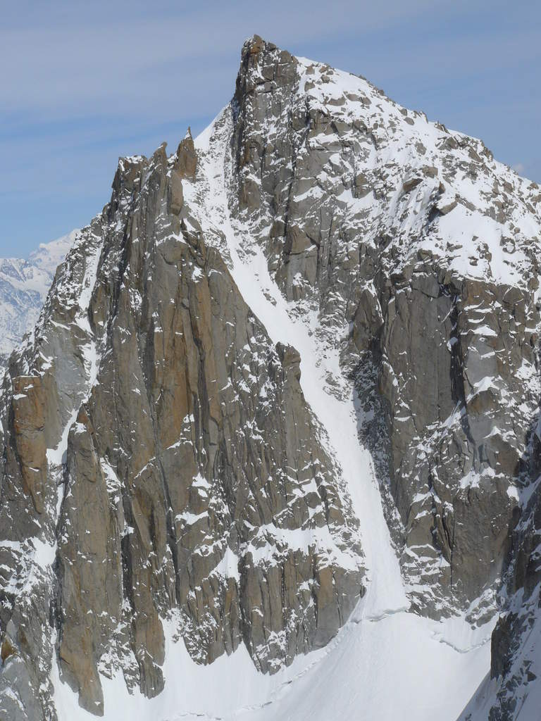
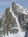 Il versante ovest della Tour Ronde: al centro il Couloir Gervasutti, salito per la prima volta da Giusto Gervasutti e Renato Chabod nel luglio 1934.

Note
Bibliografia
- François Labande, Monte Bianco Vol. 1 Guida Vallot, Edizioni Mediterranee, 1988, ISBN 88-272-0239-0.
- (FR) François Damilano, Neige, glace et mixte Tome 2, JMEditions, 2006, ISBN 978-2-9521881-3-5.
Altri progetti
 Wikimedia Commons contiene immagini o altri file su Tour Ronde
Collegamenti esterni
- (EN) Tour Ronde, su SummitPost.org.
- (EN) Tour Ronde, su Peakbagger.com.
- (FR) Scheda su camptocamp.org, su camptocamp.org.
На других языках
[de] Tour Ronde
Die Tour Ronde ist ein 3792 m hoher Berg in der Mont-Blanc-Gruppe, der rund 3,5 Kilometer östlich des Mont Blanc liegt. Über seinen Gipfel verläuft die Grenze zwischen Frankreich und Italien. Er liegt am Ostfuß des Mont Maudit und bildet die erste Erhebung im Verbindungsgrat zum Dent du Géant. Der Gipfel ist von zwei großen Gletschern umgeben, nördlich liegt der Glacier du Géant, südlich wird er vom Glacier de la Brenva umflossen.[en] Tour Ronde
The Tour Ronde (3,792 metres (12,441 ft)) is a mountain in the Mont Blanc massif of the Alps, situated on the border between France and Italy. It is a prominent mountain, some 3.5 km north-east of Mont Blanc, but is effectively part of a continuation of the south eastern spur of Mont Maudit (l'Arete de la Brenva) which forms a frontier ridge between the two countries. It is easily accessible to mountaineers and provides not only a very good viewpoint from its summit of the Brenva face and the major peaks on the southern side of Mont Blanc, but it also offers a popular introduction to alpine climbing of all grades, including a north face ascent.[fr] La Tour Ronde
La Tour Ronde est un sommet du massif du Mont-Blanc qui culmine à 3 793 ou 3 798 m d'altitude sur l'arête frontière entre la France et l'Italie, entre le col du Géant et le mont Maudit.- [it] Tour Ronde
Текст в блоке "Читать" взят с сайта "Википедия" и доступен по лицензии Creative Commons Attribution-ShareAlike; в отдельных случаях могут действовать дополнительные условия.
Другой контент может иметь иную лицензию. Перед использованием материалов сайта WikiSort.org внимательно изучите правила лицензирования конкретных элементов наполнения сайта.
Другой контент может иметь иную лицензию. Перед использованием материалов сайта WikiSort.org внимательно изучите правила лицензирования конкретных элементов наполнения сайта.
2019-2026
WikiSort.org - проект по пересортировке и дополнению контента Википедии
WikiSort.org - проект по пересортировке и дополнению контента Википедии