geo.wikisort.org - Montagne
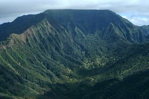
Il monte Kaʻala è il rilievo più elevato dell'isola di Oahu nell'arcipelago della Hawaii. Parte della catena dei Waiʻanae, relitto di un antico vulcano a scudo della parte occidentale dell'isola, la sua cima culmina a 1 227 metri s.l.m.[1]
| Monte Kaʻala | |
|---|---|
 | |
| Stato | |
| Stato federato | |
| Altezza | 1 227 m s.l.m. |
| Prominenza | 1 226,82 m |
| Coordinate | 21°30′25″N 158°08′34″W |
| Mappa di localizzazione | |
 Monte Kaʻala | |
La FAA continua a tenere in funzione una stazione di monitoraggio sulla cima del monte, la quale è chiusa al pubblico e custodita dall'esercito degli Stati Uniti, stazionato ai piedi del monte a Schofield Barracks. Anche da lontano la cupola bianca della stazione di monitoraggio è chiaramente visibile.
Note
- Mt. Mount Ka'ala, in Department of Forestry and Wildlife, State of Hawaii. URL consultato il 21 febbraio 2013.
Voci correlate
- Punto caldo delle Hawaii
Collegamenti esterni
- (EN) Monte Kaʻala, su Enciclopedia Britannica, Encyclopædia Britannica, Inc.
- (EN) Monte Kaʻala, su Peakbagger.com.
- (EN) Monte Kaʻala, su Geographic Names Information System, USGS.
На других языках
[de] Kaʻala
Der Kaʻala ([.mw-parser-output .IPA a{text-decoration:none}kəˈʔɐlə]) ist die höchste Erhebung der Insel Oʻahu im Archipel von Hawaii. Er liegt zwischen den Orten Haleʻiwa und Waiʻanae.[en] Kaʻala
Kaʻala or Mount Kaʻala (pronounced [kəˈʔɐlə] in Hawaiian) is the highest mountain on the island of Oahu, at 1,227 metres (4,026 ft). It is a part of the Waianae Range, an eroded shield volcano on the west side of the island. The FAA maintains an active tracking station at the summit, which is closed to the general public and secured by the US Army which is stationed at the base of the mountain, at Schofield Barracks. The tracking station can be clearly seen from afar as a white domed shaped structure.- [it] Monte Kaʻala
Текст в блоке "Читать" взят с сайта "Википедия" и доступен по лицензии Creative Commons Attribution-ShareAlike; в отдельных случаях могут действовать дополнительные условия.
Другой контент может иметь иную лицензию. Перед использованием материалов сайта WikiSort.org внимательно изучите правила лицензирования конкретных элементов наполнения сайта.
Другой контент может иметь иную лицензию. Перед использованием материалов сайта WikiSort.org внимательно изучите правила лицензирования конкретных элементов наполнения сайта.
2019-2026
WikiSort.org - проект по пересортировке и дополнению контента Википедии
WikiSort.org - проект по пересортировке и дополнению контента Википедии