geo.wikisort.org - Montagne
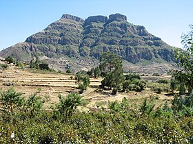
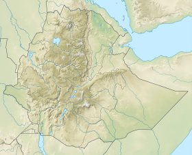
Le mont Kundudo ou Kondudo est une montagne au sommet plat, de type amba, située dans la région d'Oromia en Éthiopie. Le Kundudo culmine à 2 959 m d'altitude à l'est de la cité fortifiée de Harar, et appartient à la chaîne du même nom, longue de 13 km.
Pour l’article homonyme, voir Kundudo (cheval).
Le Kundudo est l'habitat d'une des dernières populations de chevaux sauvages du continent africain, le cheval du Kundudo, dont la survie est menacée. À la base de la montagne se trouvent d'immenses grottes, notamment découvertes par des équipes spéléologiques italiennes et françaises.
Notes et références
Voir aussi
Articles connexes
- Kundudo (cheval)
Liens externes
- Compte-rendu d'expédition spéléologique, 2011.
- (en) First Mt.Kundudo Italian missions. Ecological and social considerations. Kuni Mukhtar animal Sanctuary, a new naturalistic route. How Ethiopia should reconsider its sustainable tourism potential. 2008.
- Portail de l’Éthiopie
- Portail de la montagne
На других языках
[en] Kundudo
Kundudo or Kondudo Ego (rarely spelt as Qundudo) is a flat top mountain (or amba) in the Fafan Zone of the Somali region of Ethiopia. Part of the 13-kilometre (8 mi) range that bears its name, its summit lies east of the walled city of Harar, About 30km northwest of Jijiga area Fafan Highland district with a height of nearly 3,850 metres (12,630 ft).It is the highest peak of the Eastern Ethiopian Highlands, after the Bale region Mountain range in Jarso Wordea further south. The Highland Region has a mountain peak forest of junipers, African Oaks, Olive trees, Ceader trees, and other Subtropical highland species, that are found all over the highlands of Ethiopia, Eritrea and Western Yemen. It is a very fertile area probably the most fertile east of the central Highlands, it has a Subtropical Highland climate with 2 main rainy reasons short dry seasons in the winter with occasional rain in the higher elevations. The area on average receives around 750-1000mm of rain per year.- [fr] Kundudo
[it] Kondudo
Il Kondudo o Kundudo è una amba nella zona Eastern Hararghe della regione Oromia in Etiopia. Domina le località di Fugnan Bira o Gursum, Ejersa Goro, Sakare e Fugnan Hujuba e si staglia come monte più alto nei panorami di Harar.[ru] Кундудо (гора)
Кундудо — гора, расположенная в регионе Оромия, Эфиопия. Вершина горы лежит к востоку от стены города Харэр, с высоты около 3000 метров. Гора имеет огромные пещеры, а в южной части имеет старинные гравюры, которые не были известны до 2008 года. Гора представляет собой пастбище в тринадцать гектаров и является местом обитания оставшихся диких лошадей в Восточной Африке. Высота горы достигает 2965 метров.Текст в блоке "Читать" взят с сайта "Википедия" и доступен по лицензии Creative Commons Attribution-ShareAlike; в отдельных случаях могут действовать дополнительные условия.
Другой контент может иметь иную лицензию. Перед использованием материалов сайта WikiSort.org внимательно изучите правила лицензирования конкретных элементов наполнения сайта.
Другой контент может иметь иную лицензию. Перед использованием материалов сайта WikiSort.org внимательно изучите правила лицензирования конкретных элементов наполнения сайта.
2019-2025
WikiSort.org - проект по пересортировке и дополнению контента Википедии
WikiSort.org - проект по пересортировке и дополнению контента Википедии

