geo.wikisort.org - Mountains
Kundudo or Kondudo Ego (rarely spelt as Qundudo) is a flat top mountain (or amba) in the Fafan Zone of the Somali region of Ethiopia. Part of the 13-kilometre (8 mi) range that bears its name, its summit lies east of the walled city of Harar, About 30km northwest of Jijiga area Fafan Highland district with a height of nearly 3,850 metres (12,630 ft).It is the highest peak of the Eastern Ethiopian Highlands, after the Bale region Mountain range in Jarso Wordea further south. The Highland Region has a mountain peak forest of junipers, African Oaks, Olive trees, Ceader trees, and other Subtropical highland species, that are found all over the highlands of Ethiopia, Eritrea and Western Yemen. It is a very fertile area probably the most fertile east of the central Highlands, it has a Subtropical Highland climate with 2 main rainy reasons short dry seasons in the winter with occasional rain in the higher elevations. The area on average receives around 750-1000mm of rain per year.
| Kundudo | |
|---|---|
 | |
| Highest point | |
| Elevation | 3,850 m (12,630 ft) |
| Coordinates | 9°26′N 42°20′E |
| Geography | |
 Kundudo Location in Ethiopia | |
| Location | Fafan Zone, Somali Region, Ethiopia |
Since ancient times, it was known to be a strong hold of the Dir clan of the Somali Akisho more specifically, especially the Sub tribes called the Ego, Warre Miyo and Ejo who primarily live around that area from Awdal region, Gabilay area in Somali Territory and near the border regions, all the way to Jijiga going west deeper into the Ethiopian highlands up to the hinterland of Addis Abba slightly past the Rift Valley, Along with other Dir tribes and some Hawyie. The Akisho are a primarily agricultural tribe who farm their fertile highland territories on these mountain chains in eastern Ethiopia. They are one of the most heavily agricultural Somali tribes who invented many agricultural practices among the Somalis of the Hararghe province and Somaliland, they terrace the Hill sides for maximum Agricultural productivity this is an ancient practice to flood fields and irrigate them to keep in water during the dry season who live primarily isolated from there Somali brethren in this area, the western extant of Somali inhabited territory, some of the Akisho speak Afaan Oromo although in this area they are mostly bilingual in both Somali and Oromo. In the same range, the Goba tarara (a term for mountain) holds a vast cave known since the nineteen hundreds, whilst at the southern end the Stinico tarara holds ancient engravings, unknown until 2008, in two recently studied small open caves. The summit is a flat grassland at the very top forest closer to the bottom that continues to the Erer river which flows to Harar and Jijiga 13 hectares (32 acres) in area, and is the habitat of the only remaining feral horse population of East Africa, one of only two on the continent.
Below Kondudo lie the localities of Fugnan Bira (also named Gursum), Ego Feres, Fugnan Hujuba, Ejersa Goro, Bedada, Goba, Sakhare and Yaya Guda. Nearby is also a shrine and a singular design mosque named by the locals after Sheikh Adem Goba.
Human history
This mountain was mentioned by the British explorer Richard F. Burton, whose party traveled along its Southern base January 1854, on their way to Harar.[1]
On February 13–14, 2009, a group of six Italian and French speleologists explored a newly found cave of international interest. The cave is classified amongst the best five on the continent and is the only one in Ethiopia to contain a full variety of active speleothem kinds, or significant cave rock formations.[2] The Kundudo limestone layers have been indicated by Prof. Viganó to contain more similar caves and vast fossil fields. As a consequence of these discoveries the whole area is being proposed for the constitution of an Oromia State Park.[3] [4]
Feral horses
The feral horse herd is less than 10 strong and is threatened by extinction. Four local peasants in Bedada and Goba have been trying to tame them and have sold the docile colts; livestock is now grazing the top of the amba. The ruins of an ancient undated mosque on the amba has been transformed into a cattle pen.
Emperor Haile Selassie I obtained his first mount from the Kundudo pack 107 years ago. This makes them the oldest known feral horse population in Africa.[5]

The herd has been the focus since 2008 of six Italian and Italo-British ecologic mission to try and save it and offer locals economic alternatives to the peculiar area's destruction. Prof. Viganò, mission's head, has been given a charge to attempt a rapid intervention from the Ethiopian Environment Protection Agency, later by the Oromia Tourism Commissioner. The Addis Ababa office of the UNEP is monitoring his attempt.[6]
A second mission in March 2008 has revealed the whereabouts of the captive horses and found rock paintings in a cave in the mountain complex, giving rise to hopes of future tourism development in the area.

Seven horses were reported as then freed and presently on the amba's top by the Addis Ababa based GAG, a local interest group for the preservation of the Kundudo range and promote the Gursum area.
A major Italian aid organization is preparing a medium size aid programme that stems from the research. A series of related activities are being created to save the herd and promote the area as the end point of a tourist route named "the Extended East Route" to include Harar, the Awash National Park, the Kuni-Muktar Mountain Nyala Sanctuary and some other destinations of cultural, nature and historic interest in the East of Ethiopia, forming a destination cluster with Harar itself, including Koremi village, the Babille Elephant Sanctuary (or Harar Wildlife Sanctuary) and the nearby Dhakata valley, a number of rock painting locations between Harar and the Kundudo itself.
 Rare eccentrics in the Kundudo newly fond cave
 Coral-like rock formations
 Multi-coloured formations
 40 cm diameter ammonite on a Kundudo fossil field
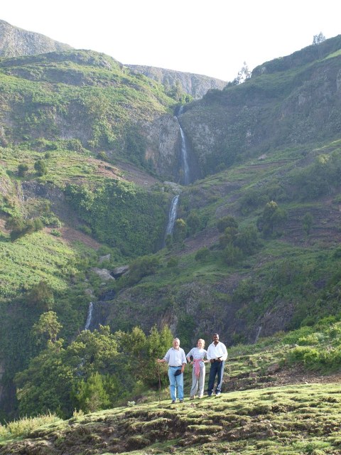
 Immis, a four jump, 250m total height waterfall off the Kundudo North Face
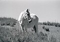 A feral horse
 Karren, or eroded rocks, a symptom of significant caves
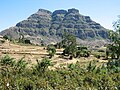 The North Face


References
- Burton, First Footsteps in East Africa, 1856; edited with additional material by Gordon Waterfield (New York: Praeger, 1966), pp. 168f
- a photo gallery
- a concept paper on the proposed Park
- "Press release". www.gursum.com. Archived from the original on 2008-04-03. Retrieved 2008-05-05.
- Leonard Moseley, Haile Selassie (London: Weidenfell and Nicholson, 1964)
- "Wild horses exist in Ethiopia, but face danger of extinction: Exploratory Team". The Ethiopian News Agency. Archived from the original on 2009-07-15. Retrieved 2008-01-21.
На других языках
- [en] Kundudo
[fr] Kundudo
Le mont Kundudo ou Kondudo est une montagne au sommet plat, de type amba, située dans la région d'Oromia en Éthiopie. Le Kundudo culmine à 2 959 m d'altitude à l'est de la cité fortifiée de Harar, et appartient à la chaîne du même nom, longue de 13 km.[it] Kondudo
Il Kondudo o Kundudo è una amba nella zona Eastern Hararghe della regione Oromia in Etiopia. Domina le località di Fugnan Bira o Gursum, Ejersa Goro, Sakare e Fugnan Hujuba e si staglia come monte più alto nei panorami di Harar.[ru] Кундудо (гора)
Кундудо — гора, расположенная в регионе Оромия, Эфиопия. Вершина горы лежит к востоку от стены города Харэр, с высоты около 3000 метров. Гора имеет огромные пещеры, а в южной части имеет старинные гравюры, которые не были известны до 2008 года. Гора представляет собой пастбище в тринадцать гектаров и является местом обитания оставшихся диких лошадей в Восточной Африке. Высота горы достигает 2965 метров.Другой контент может иметь иную лицензию. Перед использованием материалов сайта WikiSort.org внимательно изучите правила лицензирования конкретных элементов наполнения сайта.
WikiSort.org - проект по пересортировке и дополнению контента Википедии