geo.wikisort.org - Montagne
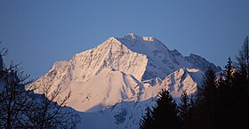
Le Habicht est une montagne qui s’élève à 3 277 m d’altitude dans les Alpes de Stubai, en Autriche.
Pour les articles homonymes, voir Habicht.
| Habicht | |||
 Vue depuis le nord-ouest. | |||
| Géographie | |||
|---|---|---|---|
| Altitude | 3 277 m[1] | ||
| Massif | Alpes de Stubai (Alpes) | ||
| Coordonnées | 47° 02′ 38″ nord, 11° 17′ 22″ est[1] | ||
| Administration | |||
| Pays | |||
| Land | Tyrol | ||
| District | Innsbruck-Land | ||
| Ascension | |||
| Première | 1836 par Peter Karl Thurwieser | ||
| Géologie | |||
| Roches | Schiste | ||
| Géolocalisation sur la carte : Autriche
Géolocalisation sur la carte : Tyrol
| |||
| modifier |
|||
Notes et références
- (de) Cet article est partiellement ou en totalité issu de l’article de Wikipédia en allemand intitulé « Habicht » (voir la liste des auteurs).
- Visualisation sur BEV.
- Portail de la montagne
- Portail des Alpes
- Portail de l'Autriche
На других языках
[de] Habicht (Berg)
Der Habicht (im Volksmund auch Hager oder Hoger) ist ein 3277 m ü. A. hoher Berg in den Stubaier Alpen in Tirol, Österreich.[en] Habicht
The Habicht is a mountain in the Stubai Alps of Austria. For a long time, the locals believed it to be the highest mountain in Tyrol, due to its prominence above the surrounding mountains. Despite what they thought, the highest peak in the Stubai Alps is Zuckerhütl which is 230 metres higher than Habicht. The name literally means "hawk" in German.- [fr] Habicht (montagne)
[it] Habicht
L'Habicht (3.277 m s.l.m. - detto anche Hager oppure Hoger) è una montagna delle Alpi dello Stubai nelle Alpi Retiche orientali. Si trova nel Tirolo austriaco.Текст в блоке "Читать" взят с сайта "Википедия" и доступен по лицензии Creative Commons Attribution-ShareAlike; в отдельных случаях могут действовать дополнительные условия.
Другой контент может иметь иную лицензию. Перед использованием материалов сайта WikiSort.org внимательно изучите правила лицензирования конкретных элементов наполнения сайта.
Другой контент может иметь иную лицензию. Перед использованием материалов сайта WikiSort.org внимательно изучите правила лицензирования конкретных элементов наполнения сайта.
2019-2025
WikiSort.org - проект по пересортировке и дополнению контента Википедии
WikiSort.org - проект по пересортировке и дополнению контента Википедии

