geo.wikisort.org - Montagne
Le djebel Nefoussa, en arabe : الجبل نفوسة al-Jabal Nefusa, en berbère nafusi : Adrar n Infusen soit « montagne des Infusen », est un massif montagneux situé dans le Nord-Ouest de la Libye, à proximité de la Tunisie, peuplé des Infusen, une communauté berbère de confession musulmane ibadite.
| Djebel Nefoussa | ||
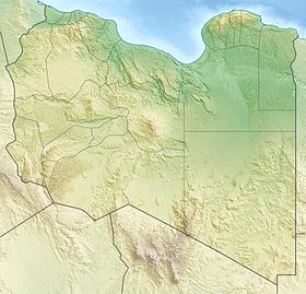
| Localisation du djebel Nefoussa en Libye. | ||
| Géographie | ||
|---|---|---|
| Altitude | 968 m[1] | |
| Longueur | 190 km | |
| Administration | ||
| Pays | ||
| Shabiyat | Al Djabal al Gharbi, Nalout | |
| modifier |
||
Géographie

Le massif du Nefoussa est situé à la limite entre la plaine côtière de la Djeffara au nord et le plateau tripolitain au sud. Les formations de ce plateau descendent en pente douce au sud et s'interrompent abruptement au nord, là où elles sont les plus élevées, donnant naissance au djebel Nefoussa[2],[3],[4] qui culmine à 968 m d'altitude[1]. Il s'étend en arc de cercle sur une longueur d'environ 190 km, depuis la frontière avec la Tunisie, jusqu'à la ville de Gharyan. Le massif surplombe la plaine côtière, dont il est séparé par un escarpement dont la hauteur de culminance atteint en certains points 350 m d'altitude. Une série de vallées profondes orientées sud-nord coupent l'escarpement en transversal[4].
Le djebel s'étend sur deux districts (shabiyat), Al Djabal al Gharbi et Nalout. D'ouest en est, on trouve les localités de Nalout, Jadou, Kabaw, Qasr el-Haj, Tarmeisa, Yefren, Gharyan et Tarhounah.
Peuplement

Le peuplement du Nefoussa comporte une double particularité dans le contexte libyen, un pays majoritairement arabophone et sunnite. En effet, il est peuplé de berbérophones, les Infusen qui parlent le nafusi et sont d'obédience ibadiste, un courant de l'islam très minoritaire.
Notes et références
- (de) Joachim Willeitner, Libyen : Tripolitanien, Syrtebogen, Fezzan und die Kyrenaika, Cologne, DuMont Reiseverlag, , 2e éd., 352 p., poche (ISBN 978-3-7701-4876-9 et 3770148762, lire en ligne), p. 14
- J. M. Asketell, S. M. Ghellali, « A palaeogeologic map of the pre-Tertiary surface in the region of the Jifarah Plain: its implication to the structural history of Northern Libya », in M. J. Salime et al. (ed.), The geology of Libya. Volume IV-VII : Third Symposium on the Geology of Libya, held at Tripoli, 27-30 septembre, 1987, Elsivier, Amsterdam, volume VI, 1991, pp. 2381-2406 (ISBN 0-444-88844-6)
- Ashour V. El-Zouki, « Stratigraphy and lithofacies of the continental clastic (Upper Jurassic and Lower Cretaceous) of Jabal Nafusah, NW Libya », in M. J. Salem, M. T. Busrewil, (ed.), The Geology of Libya: Symposium on the Geology of Libya (2nd : 1978 : Tripoli, Libya), Academic Press, New York, volume II, 1980, pp. 394-418 (ISBN 0-12-615501-1)
- Mohamed Megerisi, V. D. Mamgain, « The Upper Cretaceous-Tertiary formations of northern Libya », in M. J. Salem, M. T. Busrewil, (ed.), The Geology of Libya: Symposium on the Geology of Libya (2nd : 1978 : Tripoli, Libya), Academic Press, New York, volume I, 1980, pp. 67-72 (ISBN 0-12-615501-1)
Bibliographie
- Omar Sahli Nafousa Berber Community in Western Libya, B.A. University of Libya, 1959
- Portail de la montagne
- Portail des Berbères
- Portail de la Libye
На других языках
[de] Dschabal Nafusa
Der Dschabal Nafusa (arabisch جبل نفوسة, DMG Ǧabal Nafūsa, italienisch Gebel Nefusa, tamazight ⴰⴷⵔⴰⵔ ⵏ ⵉⵏⴼⵓⵙⵏ Adrar n Infusen) ist ein küstennahes Schichtstufen-Bergland im Nordwesten von Libyen. Das Gebiet ist nahezu ausschließlich von Berbern bewohnt.[en] Nafusa Mountains
The Nafusa Mountains (Berber: Adrar n Infusen (Nafusa Mountain), Arabic: جبل نفوسة (Western mountain)) are a mountain range in the western Tripolitania region of northwestern Libya. It also includes their regions around the escarpment formed where the northern end of the Tripolitanian Plateau meets the Mediterranean coastal plain or the Jefara.- [fr] Djebel Nefoussa
[it] Gebel Nefusa
Il Gebel Nefusa, oggi definito col nome ufficiale Eljabel Elgharbi (arabo: الجبل الغربي "il monte occidentale", berbero: Drar n Infusen)[1], è un altopiano calcareo, che si trova in Tripolitania, nella Libia nordoccidentale. Separa la pianura costiera della Gefara a nord dal pianoro dell'Hamada el-Hamra a sud.Другой контент может иметь иную лицензию. Перед использованием материалов сайта WikiSort.org внимательно изучите правила лицензирования конкретных элементов наполнения сайта.
WikiSort.org - проект по пересортировке и дополнению контента Википедии
