geo.wikisort.org - Mountains
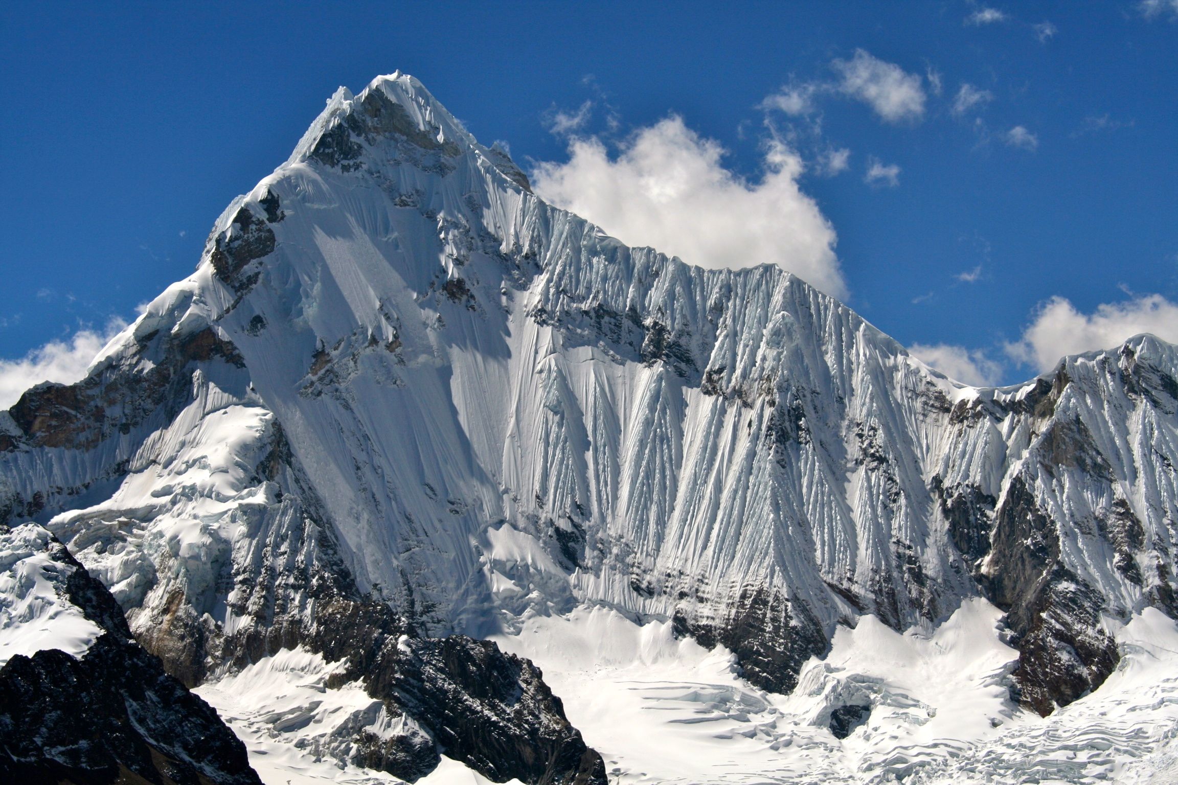
Yerupajá is a mountain of the Huayhuash mountain range in west central Peru, part of the Andes. It's located at Áncash, Bolognesi Province, Lauricocha Province. At 6,635 metres (21,768 ft) (other sources: 6,617 m (21,709 ft))[citation needed] it is the second-highest in Peru and the highest in the Huayhuash mountain range. The summit is the highest point in the Amazon River watershed, and was first reached in 1950 by Jim Maxwell and Dave Harrah, and its northern peak (Yerupajá Norte) in 1968 by the Wellingtonian Roger Bates and Graeme Dingle. Many visitors consider Yerupajá to be the most spectacular peak in South America.
| Yerupajá | |
|---|---|
 East Face, Yerupajá, May 2006 | |
| Highest point | |
| Elevation | 6,635 m (21,768 ft)[1] |
| Prominence | 2,025 metres (6,644 ft)[1] |
| Parent peak | Huascaran |
| Listing | Ultra |
| Coordinates | 10°16′06.59″S 076°54′16.92″W |
| Geography | |
 Yerupajá Peru | |
| Location | Peru, Ancash Region |
| Parent range | Andes, Huayhuash mountain range |
| Climbing | |
| First ascent | 31/07/1950 - David Harrah and Jim Maxwell (USA) |
| Easiest route | glacier/snow/ice climb |
There have been only a few successful ascents of the peak because it is one of the hardest Andean high peaks to climb. The most popular route is the southwest face. The approach is normally made from Huaraz southwards via Chiquián and Jahuacocha.
Notable ascents
- 1950 Southern flank of West Face FA[clarification needed]of peak by David Harrah and James Maxwell.[2]
- 1966 Direct West Face 2nd ascent of peak, FA of route over 13 days by Leif Patterson and Jorge Peterek.[2]
- 1968 Northeast Face FA of route by Chris Jones and Paul Dix (summit, July 30), supported by Dean Caldwell and Roger Hart (all US).[3]
- 1969 East Face by Reinhold Messner and Peter Habeler.[4]
- 2002 Main summit solo by Santiago Quintero (July 15)[5]
Elevation
Based on the elevation provided by the available Digital elevation models, SRTM2 (6558m with voids[6]), SRTM filled with ASTER (6551m with voids[7]), TanDEM-X(6110m with voids[8]), Yerupaja is about 6635 meters above sea level.[9][1] This altitude was considered due to the lack of topographic data or even handheld GPS data.[1]
The height of the nearest key col is 4592 meters,[9] so its prominence is 2025 meters. Yerupaja is listed as range or area, based on the Dominance system [10] and its dominance is 30.6%. Its parent peak is Huascaran Sur and the topographic isolation is 148.8 kilometers.[1] This information was obtained during a research by Suzanne Imber in 2014.[11]
See also
External links
- Yerupajá on Summitpost
- Complete guide to the Huayhuash Andean Circuit (in spanish)
- Elevation information about Yerupaja
- Weather Forecast at Yerupaja
References
- "Yerupaja". Andes Specialists. Retrieved 2020-04-12.
- Graber, Michael (December 1995). "Yerupaja - The West Face Direct". Climbing (93): 30. ISSN 0045-7159.
- Jones, Chris (1969). Carter, H. Adams (ed.). "Yerupaja - The Amazon Face". American Alpine Journal. Philadelphia, PA, US: American Alpine Club. 16 (43): 271–274.
- "AAC Publications - South America, Peru, Other Ranges, Yerupajá, Northeast Face and East Spur, Cordillera Huayhuash". publications.americanalpineclub.org. Retrieved 2020-04-18.
- "AAC Publications - South America, Peru, Cordillera Huayhuash, Nevado Yerupaja Grande". publications.americanalpineclub.org. Retrieved 2020-04-18.
- NASA, Jet Propulsion Laboratory. "Shuttle Radar Topographic Mission - Filled Data V2". Retrieved 12 April 2020.
- "ASTER GDEM Project". ssl.jspacesystems.or.jp. Retrieved 2020-04-14.
- TanDEM-X, TerraSAR-X. "Copernicus Space Component Data Access". Retrieved 12 April 2020.
- "Andean Mountains - All above 5000m". Andes Specialists. Retrieved 2020-04-12.
- "Dominance - Page 2". www.8000ers.com. Retrieved 2020-04-12.
- ap507. "Academic and adventurer describes the incredible task of climbing and cataloguing one of the most remote regions of the South American Andes mountains — University of Leicester". www2.le.ac.uk. Retrieved 2020-04-12.
| Authority control |
|
|---|
This Ancash Region geography article is a stub. You can help Wikipedia by expanding it. |
На других языках
[de] Yerupaja
Der Yerupaja oder Nevado Yerupaja ist ein Berg der Cordillera Huayhuash im nördlichen Zentralperu und Teil der Hochgebirgskette der Anden.- [en] Yerupajá
[es] Yerupajá
El nevado de Yerupajá está situado en la cordillera de Huayhuash, en las nacientes del Alto Marañón,[1] en el centro del Perú, América del Sur. Es el pico más alto de la cordillera, tiene 6 634 m de altitud, lo que lo convierte en el segundo del Perú, siendo el primero el Huascarán y el de mayor altura de la cuenca amazónica. La primera ascensión a su cima fue realizada en 1950 por Jim Maxwell y David Harrah.[fr] Yerupajá
Le Yerupajá ou Nevado Yerupaja est le plus haut sommet de la cordillère Huayhuash au Pérou et le deuxième sommet du pays. L'un des plus difficiles à escalader parmi les hauts pics des Andes, il est situé à la limite des régions d'Ancash et de Huánuco, non loin de la ville de Huaraz, au sein du parc national de Huascarán. Il fait partie des douze plus hauts sommets d'Amérique et est le second au Pérou après le Huascarán.[it] Yerupaja
Il monte Yerupaja o Nevado Yerupaja (6.635 m s.l.m.) è la più alta vetta della Cordillera Huayhuash in Perù e la seconda del paese dopo il monte Huascarán. È situata al confine tra la regione Ancash e quella di Huánuco non lontano dalla città di Huaraz, all'interno del Parco nazionale del Huascarán.[ru] Ерупаха
Ерупа́ха[2][3] (исп. Yerupajá) — гора в Андах высотой 6617 м, вторая по высоте точка Перу и самая высокая гора хребта Кордильера-Уайуаш. Первое восхождение на вершину совершили в 1950 году Джим Максвелл[en] и Дейв Хара[en], северная вершина (Ерупаха Северная) впервые пройдена в 1968 году веллингтонцами Роджером Бейтсом[en] и Грэмом Динглом[en].Другой контент может иметь иную лицензию. Перед использованием материалов сайта WikiSort.org внимательно изучите правила лицензирования конкретных элементов наполнения сайта.
WikiSort.org - проект по пересортировке и дополнению контента Википедии