geo.wikisort.org - Mountains
The White Cloud Mountains are part of the Rocky Mountains of the western United States, located in central Idaho, southeast of Stanley in Custer County. The range is located within the Sawtooth National Recreation Area (SNRA) and partially within the Cecil D. Andrus–White Clouds Wilderness.[1]
| White Cloud Mountains | |
|---|---|
 White Cloud Mountains | |
| Highest point | |
| Peak | Castle Peak |
| Elevation | 11,815 ft (3,601 m) |
| Coordinates | 44°02′22″N 114°35′07″W |
| Dimensions | |
| Length | 25 mi (40 km) N/S |
| Width | 32 mi (51 km) E/W |
| Area | 461 sq mi (1,190 km2) |
| Geography | |
 White Cloud Mountains | |
| Country | United States |
| State | Idaho |
| Parent range | Rocky Mountains |
| Borders on | Sawtooth Mountains and Boulder Mountains |
The White Cloud Mountains are located on National Forest land, with numerous trails in the area. Camping is permitted anywhere on the national forest land and there are no fees to access the area.[2] Primary access to the area is via State Highway 75, the Salmon River Scenic Byway, which accompanies the main Salmon River as it descends along the range's western and northern perimeter.
The highest peak in the White Cloud Mountains, and the SNRA, is Castle Peak at 11,815 ft (3,601 m).[3] The Sawtooth Mountains are about twenty miles (32 km) west of the White Clouds, on the west side of the river and highway, and the Boulder Mountains are directly south of the White Clouds.
Peaks

This list is incomplete; you can help by adding missing items. (June 2012) |
| Mountain Peak | Elevation | Prominence | Isolation | Location | Easiest Route |
|---|---|---|---|---|---|
| Castle Peak | 11,814 ft 3601 m | 4,016 ft 1224 m | 27.3 mi 43.9 km |
44.039558°N 114.585266°W | Class 3 |
| Calkins Peak | 11,486 ft 3501 m | 1,247 ft 380 m | 5.8 mi 9.33 km |
44.119646°N 114.620093°W | Class 3 |
| D. O. Lee Peak | 11,342 ft 3457 m | 541 ft 165 m | 1.25 mi 2.01 km |
44.102674°N 114.628671°W | Class 3 |
| Lonesome Lake Peak | 11,302 ft 3445 m | 801 ft 244 m | 1.11 mi 1.78 km |
44.075396°N 114.612077°W | Class 2 |
| Peak 11,272 | 11,280 ft 3438 m | 673 ft 205 m | 1.24 mi 2 km |
44.09126°N 114.609296°W | Class 3 |
| White Cloud Peak 9 | 11,263 ft 3433 m | 463 ft 141 m | 0.61 mi 0.98 km |
44.111383°N 114.626608°W | Class 2 |
| Chinese Wall | 11,237 ft 3425 m | 197 ft 60 m | 0.53 mi 0.86 km |
44.127324°N 114.618743°W | unknown |
| White Cloud Peak 10 | 11,102 ft 3384 m | 341 ft 104 m | 0.53 mi 0.85 km |
44.117573°N 114.609906°W | Class 4 |
| Merriam Peak | 10,919 ft 3328 m | 518 ft 158 m | 0.57 mi 0.91 km |
44.052126°N 114.580744°W | Class 3 |
| Patterson Peak | 10,873 ft 3314 m | 252 ft 77 m | 1.7 mi 2.74 km |
44.04880°N 114.61780°W | Class 2 |
| White Cloud Peak 7 | 10,778 ft 3285 m | 677 ft 206 m | 1.48 mi 2.38 km |
44.12254°N 114.65374°W | Class 3 |
| Fourth of July Peak | 10,712 ft 3265 m | 1,133 ft 345 m | 2.54 mi 4.09 km |
44.03010°N 114.63500°W | Class 2 |
| White Cloud Peak 5 | 10,597 ft 3230 m | 977 ft 298 m | 0.91 mi 1.46 km |
44.13550°N 114.65810°W | Class 4 |
| White Cloud Peak 3 | 10,587 ft 3227 m | 808 ft 246 m | 1.44 mi 2.32 km |
44.15620°N 114.65990°W | Class 3 |
| White Cloud Peak 8 | 10,558 ft 3218 m | 457 ft 139 m | 0.94 mi 1.51 km |
44.10503°N 114.64697°W | Class 3 |
| Washington Peak | 10,518 ft 3206 m | 859 ft 262 m | 2.37 mi 3.81 km |
44.00850°N 114.67260°W | Class 2 |
| Ebony Peak | 10,512 ft 3204 m | 334 ft 102 m | 1.13 mi 1.82 km |
44.01770°N 114.65320°W | Class 3 |
| Watson Peak | 10,449 ft 3185 m | 353 ft 108 m | 0.68 mi 1.09 km |
44.130972°N 114.685666°W | Class 3 |
| White Cloud Peak 4 | 10,449 ft 3185 m | 810 ft 247 m | 1.01 mi 1.63 km |
44.13890°N 114.67790°W | Class 3 |
| Croseus Peak | 10,387 ft 3166 m | 188 ft 57 m | 0.47 mi 0.76 km |
43.997965°N 114.651733°W | unknown |
| White Cloud Peak 1 | 10,354 ft 3156 m | 453 ft 138 m | 0.88 mi 1.42 km |
44.16870°N 114.65777°W | Class 2 |
| Blackmon Peak | 10,308 ft 3142 m | 400 ft 122 m | 2.46 mi 3.96 km |
44.05820°N 114.65140°W | Class 2 |
| White Cloud Peak 2 | 10,272 ft 3131 m | 491 ft 150 m | 0.81 mi 1.3 km |
44.15860°N 114.67550°W | Class 3 |
| White Cloud Peak 6 | 10,256 ft 3126 m | 316 ft 96 m | 0.37 mi 0.6 km |
44.13046°N 114.64765°W | Class 2 |
| Peak 10,041 | 10,039 ft 3060 m | 581 ft 177 m | 0.73 mi 1.17 km |
43.956400°N 114.707000°W | Class 2 |
| Lookout Mountain | 9,954 ft 3034 m | 1,854 ft 565 m | 8.3 mi 13.36 km |
44.192659°N 114.758948°W | Class 1 |
| Peak 9,988 | 9,954 ft 3034 m | 728 ft 222 m | 1.46 mi 2.35 km |
43.94510°N 114.66720°W | Class 2 |
| Horton Peak | 9,895 ft 3016 m | 276 ft 84 m | 0.83 mi 1.34 km |
43.96580°N 114.74750°W | Class 1 |
| Bible Back Mountain | 9,885 ft 3013 m | 428 ft 130 m | 1.15 mi 1.85 km |
43.997688°N 114.637843°W | unknown |
Lakes
See List of lakes of the White Cloud Mountains
Mine proposal
In 1970, it was proposed that the White Cloud Mountains be the site of an open-pit mine. The proposal became a major issue in Idaho's 1970 gubernatorial election. Incumbent Republican governor Don Samuelson favored the mine, as it would generate an estimated $4 million in revenue to the state. However, his Democratic opponent, Cecil Andrus, opposed the mine on conservation grounds. His stance was backed by many of the state's urban residents, who enjoyed vacationing at the mountains.[6] Andrus won the election by more than four points, and it has been suggested that Andrus's stance on the mine was a contributing factor to his victory, and in particular to his victories in the normally Republican-leaning urban parts of the state.[6][7]
Photos
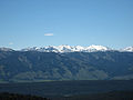 White Cloud Mountains viewed from Sawtooth Mountains
 Washington Lake in the White Cloud Mountains
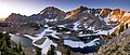 Castle Peak to left of center
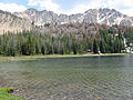 Fourth of July Lake in the White Cloud Mountains
 Castle Peak
 White Cloud Mountains
 Warm Spring Creek in White Cloud Mountains
 Warm Springs Meadow in White Cloud Mountains
 White Cloud Mountains
 White Cloud Mountains across Sawtooth Valley
 Hikers leaving Quiet Lake, which sits at the base of Castle Peak and Merriam Peak.
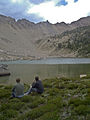 Hikers eating lunch at Shallow Lake with the Devil's Staircase on the horizon.


See also
References
- "White Clouds". Summitpost.org. Retrieved 2012-05-03.
- "Sawtooth National Forest". U.S. Forest Service. Retrieved 2012-05-03.
- "White Cloud Mountains". Peakbagger.com. Retrieved 2012-05-03.
- Sawtooth National Forest. "Sawtooth National Forest" [map].1:126,720, 1"=2 miles. Twin Falls, Idaho: Sawtooth National Forest, United States Forest Service, 1998.
- "White Cloud Peak List". Summitpost.org. Retrieved 2012-05-04.
- Dumcombe, Herbert; Martin, Boyd (June 1971). "The 1970 Election in Idaho". The Western Political Quarterly. 24 (2): 292–300. doi:10.2307/446873. JSTOR 446873. Retrieved February 8, 2019.
- Barker, Rocky. "Andrus spent his life protecting this iconic Idaho wilderness; now it will carry his name". Idaho Statesman. The McClatchy Company. Retrieved February 19, 2019.
External links
- Peak Bagger.com - White Cloud Mountains
- Visit Idaho.org - official state tourism site
- Idaho Summits.com - Castle Peak - 11,815 ft.
| Authority control: National libraries |
|---|
На других языках
- [en] White Cloud Mountains
[fr] Monts White Cloud
Les monts White Cloud sont un massif montagneux du centre de l’État de l'Idaho dans les montagnes Rocheuses. Ils culminent au pic Castle à 3 601 m d'altitude.Другой контент может иметь иную лицензию. Перед использованием материалов сайта WikiSort.org внимательно изучите правила лицензирования конкретных элементов наполнения сайта.
WikiSort.org - проект по пересортировке и дополнению контента Википедии