geo.wikisort.org - Mountains
The Vignemale (French pronunciation: [viɲmal]; Occitan: Vinhamala, Aragonese: Comachibosa, Catalan: Vinyamala), at 3,298 metres, is the highest of the French Pyrenean summits (the highest in the whole of the range is Pic d'Aneto). It lies on the border between the Department of Hautes-Pyrénées (Nauts Pirenèus / Hauts Pirenèus), in Occitanie and Gascony, France and Sobrarbe, in Huesca, Aragon, Spain, and the peak is split between the two countries.
This article needs additional citations for verification. (January 2021) |
| Vignemale | |
|---|---|
 Vignemale | |
| Highest point | |
| Elevation | 3,298 m (10,820 ft) |
| Prominence | 1,029 m (3,376 ft) |
| Coordinates | 42°46′36″N 0°08′35″W |
| Geography | |
| Parent range | Pyrenees |
| Climbing | |
| First ascent | August 2, 1792 |
| Easiest route | Through the Ossoue glacier |

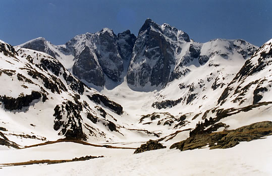
The Vignemale is the name given to the mountain massif in French, which also straddles into Spain. It consists of several distinct summits, the predominant ones being Grand Vignemale or Pique-Longue (in French) / Pica Longa (in Occitan and Catalan) / Punda de Comabichosa (in Aragonese)[1] (3298 m), Pointe Chausenque / Punta Chausenca (3,204 m) and Petit Vignemale / Petita Vinhamala (3,032 m). The Vignemale is also the site of the second largest of the Pyrenean glaciers (after the one on Aneto), the Ossoue / Osso (with around 0.6 km2), across which the "voie normale", or standard route to the summit travels.
One of its most dramatic aspects is the North Face upon which lie a number of serious ascent routes requiring skill and commitment. Below the North Face is the impressively situated mountain refuge - the Refuge des Oulettes de Gaube / Refugi d’eths Oletas de Gauba. The approach from the north entails a delightful walk up to and around the picturesque Lac de Gaube / Gauba giving increasingly dramatic views of the mountain.
Almost synonymous with the Vignemale is the name of Count Henry Russell, an eccentric of the Victorian era who developed a lifelong passion for the mountain.
The first documented, "official" ascent of this peak was by English landowner and traveller Anne Lister and three local guides in 1838.[2][3][4]
Gallery
 Count Henry Russell in front of one of his caves on the Vignemale


References
- "Vinhamala o Comachibosa (3298m) pel corredor de la Moskowa, vall de l'Ara", Muntanyaviva.cat, 2007 (in Catalan with Occitan and Aragonese names). [Accessed 12/05/2019]
- "Anne Lister's Ascent of Vignemale", by Miss Vivien Ingham, Alpine Journal, No. 73 (1968), p. 199-204. [Accessed 12/05/2019]
- "The Life and Loves of Anne Lister", by Rebecca Woods, BBC, 3 May 2019. [Accessed 12/05/2019]
- "Vinhamala o Comachibosa (3298m) pel corredor de la Moskowa, vall de l'Ara", Muntanyaviva.cat, 2007 (in Catalan). [Accessed 12/05/2019]
External links
Authority control | |
|---|---|
| General |
|
| National libraries | |
На других языках
[de] Vignemale
Der Vignemale bzw. Pico Viñamala ist einer der rund 200 über 3.000 Meter hohen Berge in den Pyrenäen. Der 3298 m hohe Gipfel des Pique-Longue liegt auf dem Grenzkamm zwischen der spanischen Provinz Huesca im Norden der Region Aragonien und der Gemeinde des Cauterets im französischen Département Hautes-Pyrénées.- [en] Vignemale
[es] Pico Viñamala
El Pico Viñamala (en francés: Vignemale; en aragonés: Comachibosa) está situado en los Pirineos, entre la provincia de Huesca (España) y el departamento de Altos Pirineos (Francia). En la cara española (Valle de Bujaruelo), forma parte de la zona periférica del parque nacional de Ordesa y Monte Perdido, mientras que la francesa está dentro del Parque Nacional de los Pirineos.[fr] Vignemale
Le Vignemale, plus précisément la pique Longue, est un sommet des Pyrénées, situé à la frontière franco-espagnole, dans le massif du Vignemale. Il est, avec ses 3 298 m (ou 3 299 m selon des cartes espagnoles), le point culminant des Pyrénées françaises[3], des Hautes-Pyrénées, de la région Occitanie et de l'ancienne province de Gascogne. C'est aussi le 16e plus haut sommet de toute la chaîne des Pyrénées selon la liste officielle des 212 pics à plus de 3 000 mètres pyrénéens.[it] Vignemale
Il Vignemale (in spagnolo Pico Viñamala), chiamato anche Pique Longue o Pico de Camachinos, è una montagna dei Pirenei, situata presso la frontiera franco-spagnola, facente parte del massiccio del Vignemale: con i suoi 3.298 è la vetta pirenaica più alta di Francia e della regione dell'Occitania; è inoltre la sedicesima vetta più alta della catena dei Pirenei[1] e la più alta tra quelle la cui cima è posta esattamente sul confine tra Francia e Spagna[2].[ru] Виньмаль
Виньмаль (фр. Vignemale) — горная вершина во Французских Пиренеях. Расположена на границе Испании и Франции. Высота — 3299 м.Другой контент может иметь иную лицензию. Перед использованием материалов сайта WikiSort.org внимательно изучите правила лицензирования конкретных элементов наполнения сайта.
WikiSort.org - проект по пересортировке и дополнению контента Википедии