geo.wikisort.org - Mountains
Verkhny Zub (Russian: Верхний Зуб; Shor: Амзас-Таскыл;[2] Khakas: Тигір тізі) is a peak in Kemerovo Oblast, Russia. It is the highest point of the federal subject.[1]
| Verkhny Zub | |
|---|---|
| Верхний Зуб / Амзас-Таскыл / Тигір тізі | |
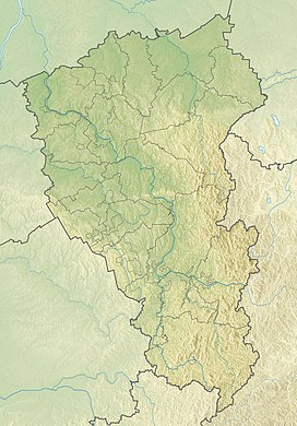
Location in Kemerovo Oblast, Russia  Verkhny Zub Verkhny Zub (Russia) | |
| Highest point | |
| Elevation | 2,178 m (7,146 ft)[1] |
| Prominence | 385 m (1,263 ft)[1] |
| Coordinates | 53°50′17″N 89°14′14″E[1] |
| Geography | |
| Location | Kemerovo Oblast, Russia |
| Parent range | Kuznetsk Alatau South Siberian Mountains |
The name of the mountain in the Khakas language "Тигір тізі" means "heavenly tooth".[3] The mountain is part of the Kuznetsk Alatau State Nature Reserve, a protected area.[4]
Description
Verkhny Zub is a 2,178 metres (7,146 ft) high mountain located in the Kuznetsk Alatau, South Siberian System.[1] It rises in the southern area of the range, in the Mezhdurechensky Urban Okrug at the eastern limit of Kemerovo Oblast, near the border of Khakassia.[5][6]
At the foot of the mountain there are numerous cirque lakes. Dark coniferous taiga grows on the lower mountain slopes. On steep slopes up to a height of 1,300 metres (4,300 ft) there is mountain tundra, above which there is the nival zone with snowfields at the top.[7]
See also
- Highest points of Russian Federal subjects
- List of mountains and hills of Russia
References
- Gora Verkhniy Zub - Peak Visor
- Сибирская Советская энциклопедия. Том первый. А - Ж p. 96
- Kuznetsk Alatau - Great Soviet Encyclopedia
- Кузнецкий Алатау, государственный природный заповедник (Kuznetsk Alatau State Nature Reserve)
- "Топографска карта N-45, G; M 1:1 000 000 - Topographic USSR Chart (in Russian)". Retrieved 27 January 2022.
- Google Earth
- Энциклопедия Республики Хакасия: [в 2 т.] (Encyclopedia of the Republic of Khakassia) / Правительство Респ. Хакасия; [науч.-ред. совет.: В. А. Кузьмин (пред.) и др.]. — Абакан: Поликор, 2007. Т. 1: [А — Н]. — 2007. — 430, [2] с.: ил., портр. — Библиогр. в конце слов. ст. С. 109.
External links
- Вершина Верхний зуб. Кузнецкий Алатау. Горный массив на юге Западной Сибири. Кемеровская область, Хакасия
- Гора Верхний Зуб (2178 м) Wikimapia
На других языках
- [en] Verkhny Zub
[ru] Верхний Зуб
Верхний Зуб (шорск. Амзас-Таскыл, хак. Тигір тізі — небесный зуб) — гора на границе Хакасии и Кемеровской области, являясь для последней самой высокой точкой. Высота — 2178,0 м над уровнем моря[1].Другой контент может иметь иную лицензию. Перед использованием материалов сайта WikiSort.org внимательно изучите правила лицензирования конкретных элементов наполнения сайта.
WikiSort.org - проект по пересортировке и дополнению контента Википедии
