geo.wikisort.org - Mountains
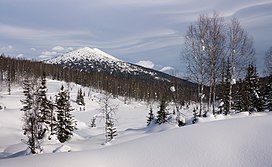
Kuznetsk Alatau (Russian: Кузнецкий Алатау) is a mountain range in southern Siberia, Russia. The range rises in the Altai-Sayan region of the South Siberian Mountains, northwest of Mongolia. The Siberian Railway skirts the northern limit of the range.[2]
| Kuznetsk Alatau | |
|---|---|
| Кузнецкий Алатау | |
 | |
| Highest point | |
| Peak | Staraya Krepost |
| Elevation | 2,217 m (7,274 ft) |
| Coordinates | 53°51′34″N 89°18′01″E[1] |
| Dimensions | |
| Length | 300 km (190 mi) SW / NE |
| Width | 150 km (93 mi) |
| Geography | |
| Country | Russia |
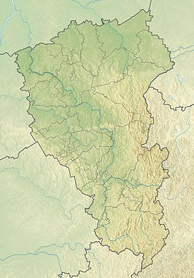
| Federal subject | Khakassia Kemerovo Oblast |
| Range coordinates | 53°45′N 89°15′E |
| Parent range | Altai/Sayan South Siberian System |
| Geology | |
| Orogeny | Alpine orogeny |
| Age of rock | Proterozoic, Lower Paleozoic |
| Type of rock | Gabbro, diorite, granite and syenite intrusive rocks |


Aeroflot Flight 593 crashed in the Kuznetsk Alatau mountain range in 1994.[3]
Geography
The Kuznetsk Alatau consists of several ridges of medium height stretching for about 300 kilometres (186 mi) between the Kuznetsk Depression and the Minusinsk Depression. The highest peak is 2,217 metres (7,274 ft) high Staraya Krepost, another important peak is 2,178 metres (7,146 ft) high Verkhny Zub. The Abakan Range is at the southern limit and to the north the range descends gradually to the West Siberian Plain. To the east lies the basin of the Yenisei. The mountains have generally a smooth outline with rather steep western slopes and gentler eastern ones.[4][2]
The range is composed mainly of metamorphic rocks rich in iron, manganese, nephelines, and gold.
Flora
The Siberian fir overwhelmingly predominates in the forest belt except for its upper part where, at the tree line (1300–1900 m), the siberian pine becomes dominant. The highlands are occupied mostly by vast large-stoned screes, and also by patches of subalpine meadows and, on some southern mountain massifs, of bushy, lichen and moss tundras. The basin of the Kondoma River in Gornaya Shoriya is remarkable for the Siberian lime-tree woods which are thought to be the relics of a pre-Pleistocene nemoral vegetation of Siberia. All over the upland, the forest openings are occupied by long forb forest meadows.[5]
See also
- Kuznetsk Alatau Nature Reserve
- Geography of South-Central Siberia
 Siberia portal
References
- Staraya Krepost - Peakbagger
- Кузнецкий Алатау / Great Soviet Encyclopedia: in 30 vols. / Ch. ed. A.M. Prokhorov. - 3rd ed. - M. Soviet Encyclopedia, 1969-1978.
- Learmount, David; Velovich, Alexander (27 April – 3 May 1994). "FDR backs A310 crash allegations". Flight International: 5. Archived from the original on 7 October 2016.
- Korshunov & Gorbunov. Asian Russia, A geographic sketch, (1995)
- "A geographic sketch, the text from Korshunov & Gorbunov (1995)".
External links
 Media related to Kuznetsk Alatau at Wikimedia Commons
На других языках
[de] Kusnezker Alatau
Der Kusnezker Alatau (russisch Кузне́цкий Алата́у; kirgisisch Alatau = „buntes Gebirge“) ist ein bis 2211,3 m[1] hohes Hochgebirge im Süden Russlands, Asien.- [en] Kuznetsk Alatau
[fr] Alataou de Kouznetsk
L'Alataou de Kouznetsk (en russe : Кузнецкий Алатау, dérivé du turkmène : Ala « bariolé » et Taou « montagne ») est un chaînon de moyenne montagne au nord-ouest du Saïan occidental dans l'oblast de Kemerovo dans le sud de la Sibérie occidentale.[it] Kuzneckij Alatau
Kuzneckij Alatau (in russo: Кузнецкий Алатау?) è una catena montuosa nella Siberia meridionale, situata tra la depressione di Kuzneck e la depressione di Minusinsk. La sua lunghezza è di circa 300 km, mentre raggiunge un'altezza massima di 2178 metri. Fa parte dei sistemi montuosi dell'Asia centrale.[ru] Кузнецкий Алатау
Кузне́цкий Алата́у (от тюрк. ала — «пёстрый» и тау — «гора») — низко-средневысокое нагорье в системе Саяно-Алтайской горной области на юге Западной Сибири, протяжённостью около 300 км с юга на север и шириной до 150 км. Наибольшая высота — 2217 м (плато Старая Крепость)[1]. Кузнецкий Алатау представляет собой не единый хребет, а состоит из нескольких хребтов средней высоты, между которыми находятся долины рек. Является водоразделом рек Томь и Чулым (притоки Оби).Другой контент может иметь иную лицензию. Перед использованием материалов сайта WikiSort.org внимательно изучите правила лицензирования конкретных элементов наполнения сайта.
WikiSort.org - проект по пересортировке и дополнению контента Википедии


