geo.wikisort.org - Mountains
Vennacher Needle is a 12,995-foot-elevation (3,961 meter) mountain summit located in Kings Canyon National Park, in Fresno County of northern California, United States.[3] It is situated west of the crest of the Sierra Nevada mountain range, and 1.4 miles (2.3 km) north of Mount Ruskin.[1] Topographic relief is significant as the east aspect rises nearly 2,300 feet (700 meters) above the Upper Basin of South Fork Kings River in one mile. The John Muir Trail, which passes one mile to the east of this mountain, provides one possible approach option. This mountain's name has been officially adopted by the United States Board on Geographic Names.[3]
| Vennacher Needle | |
|---|---|
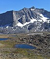
 North aspect, from JMT in Upper Basin | |
| Highest point | |
| Elevation | 12,995 ft (3,961 m)[1] |
| Prominence | 889 ft (271 m)[1] |
| Parent peak | Twin Peaks ( 13,061 ft)[2] |
| Isolation | 2.85 mi (4.59 km)[2] |
| Coordinates | 36°59′56″N 118°28′26″W[3] |
| Geography | |
 Vennacher Needle Location in California  Vennacher Needle Vennacher Needle (the United States) | |
| Location | Kings Canyon National Park Fresno County California, U.S. |
| Parent range | Sierra Nevada |
| Topo map | USGS Mount Pinchot |
| Geology | |
| Type of rock | granitic |
| Climbing | |
| Easiest route | class 2[2] Southeast slope |
Climate
According to the Köppen climate classification system, Vennacher Needle is located in an alpine climate zone.[4] Most weather fronts originate in the Pacific Ocean, and travel east toward the Sierra Nevada mountains. As fronts approach, they are forced upward by the peaks (orographic lift), causing them to drop their moisture in the form of rain or snowfall onto the range. Precipitation runoff from this mountain drains into tributaries of the Kings River.
Gallery
 Vennacher Needle
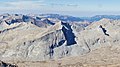 Vennacher Needle seen from Split Mountain
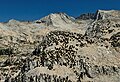 Vennacher Needle from southwest


See also
References
- "Vennacher Needle, California". Peakbagger.com. Retrieved 2021-04-29.
- "Vennacher Needle - 12,995' CA". listsofjohn.com. Retrieved 2021-04-29.
- "Vennacher Needle". Geographic Names Information System. United States Geological Survey. Retrieved 2021-04-29.
- Peel, M. C.; Finlayson, B. L.; McMahon, T. A. (2007). "Updated world map of the Köppen−Geiger climate classification". Hydrol. Earth Syst. Sci. 11. ISSN 1027-5606.
External links
- Weather forecast: Vennacher Needle
- Summit photos
Другой контент может иметь иную лицензию. Перед использованием материалов сайта WikiSort.org внимательно изучите правила лицензирования конкретных элементов наполнения сайта.
WikiSort.org - проект по пересортировке и дополнению контента Википедии