geo.wikisort.org - Mountains
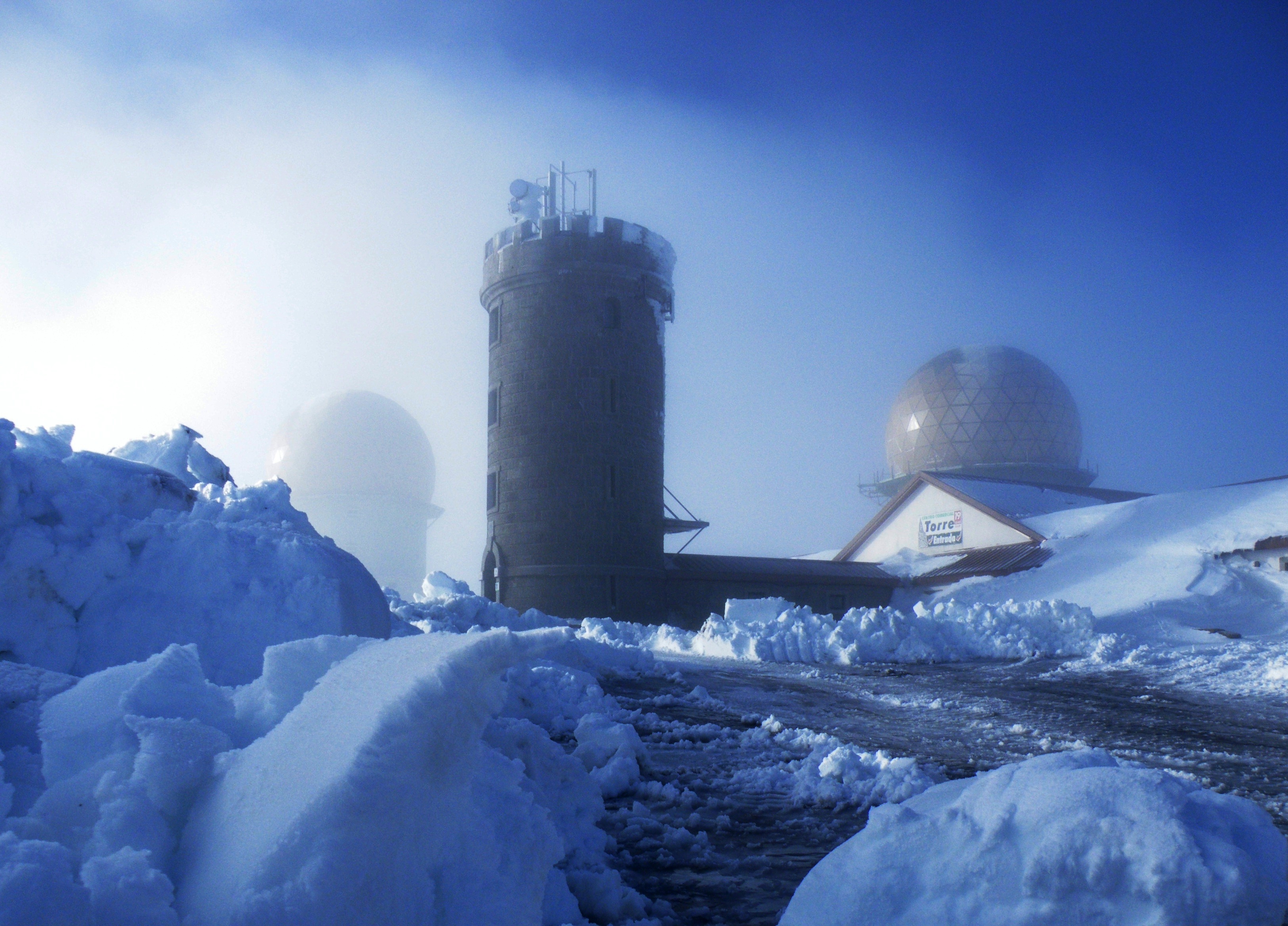
Torre (English: Tower) is the highest point of mainland Portugal, and the second-highest in the country overall (only Mount Pico, in the Azores, is higher). This point is not a distinctive mountain summit, but rather the highest point in a plateau. Torre has an unusual feature of being a summit that is accessible by paved road, the Regional Road 339 (R 339), formerly National Road 339 (N 339).
| Torre | |
|---|---|
 Trig point that marks the highest point of Continental Portugal. | |
| Highest point | |
| Elevation | 1,993 m (6,539 ft) |
| Prominence | 1,204 m (3,950 ft) |
| Parent peak | Torre Cerredo |
| Isolation | 159 km (99 mi) |
| Listing | Extreme points of Portugal |
| Coordinates | 40°19′18.8″N 07°36′46.6″W |
| Geography | |
 Torre Portugal | |
| Location | Seia, Guarda District, Portugal |
| Parent range | Serra da Estrela (part of Sistema Central) |
| Climbing | |
| First ascent | Unknown |
| Easiest route | Drive |
It is located in a mountain range named Serra da Estrela, on the border between the municipalities of Seia, District of Guarda and Covilhã, District of Castelo Branco.

The actual elevation of this area is 1,993 metres (6,537 feet), according to measures realized by the Instituto Geográfico do Exército (a military organization). Right in the highest point of the mountain range, situated in the middle of a roundabout, near a road that connects the cities of Seia and Covilhã, a trig point that shows the highest point in Serra da Estrela was built.
Near Torre, there are a restaurant, stores with typical products of this region, like the Serra da Estrela cheese, and a ski center called Vodafone Ski Resort, situated in the municipality of Seia. However, the nearest urban area of this place is the city of Covilhã, 20 km (12 mi) away, and the nearest accommodations are situated in the village of Penhas da Saúde, 10 minutes away.
Climate
Torre is the culminating point of the Serra da Estrela range and as such tends to present the lowest temperatures and highest precipitation levels. The climate is defined as a transition between the typical Mediterranean climates seen south of the range and the not-so-typical oceanic climates found north of the range. Precipitation is very high, with around 2,400 mm (94 in), but when compared to lower valley regions of the range, rain is rather weak and continuous.[1] Snow can occur anywhere between October and May, mostly in February, but can be irregular.[2][3]
| Climate data for Torre, 1971-2000 | |||||||||||||
|---|---|---|---|---|---|---|---|---|---|---|---|---|---|
| Month | Jan | Feb | Mar | Apr | May | Jun | Jul | Aug | Sep | Oct | Nov | Dec | Year |
| Average high °C (°F) | 2.5 (36.5) |
3.0 (37.4) |
4.0 (39.2) |
7.5 (45.5) |
10.5 (50.9) |
13.5 (56.3) |
17.5 (63.5) |
17.5 (63.5) |
14.0 (57.2) |
8.5 (47.3) |
4.5 (40.1) |
3.0 (37.4) |
8.8 (47.9) |
| Daily mean °C (°F) | 0.8 (33.4) |
1.2 (34.2) |
2.3 (36.1) |
4.3 (39.7) |
7.2 (45.0) |
10.5 (50.9) |
14.3 (57.7) |
14.3 (57.7) |
11.7 (53.1) |
6.5 (43.7) |
3.2 (37.8) |
1.5 (34.7) |
6.5 (43.7) |
| Average low °C (°F) | −1.0 (30.2) |
−0.5 (31.1) |
0.5 (32.9) |
1.0 (33.8) |
4.0 (39.2) |
7.5 (45.5) |
11.0 (51.8) |
11.0 (51.8) |
9.5 (49.1) |
4.5 (40.1) |
2.0 (35.6) |
0.0 (32.0) |
4.1 (39.4) |
| Average rainfall mm (inches) | 350 (13.8) |
300 (11.8) |
180 (7.1) |
240 (9.4) |
200 (7.9) |
100 (3.9) |
30 (1.2) |
30 (1.2) |
120 (4.7) |
220 (8.7) |
270 (10.6) |
400 (15.7) |
2,440 (96) |
| Source: IPMA[4] | |||||||||||||
References
- Mora 2006, p. 84
- Mora 2006, p. 80
- Mora, Carla Andreia da Silva (2006). "Climas da Serra da Estrela. Características regionais e particularidades locais dos planaltos e do alto Vale do Zêzere" (PDF) (in Portuguese). Retrieved 15 June 2021.
- "Gráficos Monitorização Diária". IPMA.
Sources
- (in English) Serra da Estrela Forecast, Snow Report and Resort Information
- (in English and Portuguese) Região de Turismo da Serra da Estrela
- (in English and Portuguese) Câmara Municipal da Covilhã (Covilhã City Hall)
На других языках
[de] Torre (Serra da Estrela)
Der Torre (nach portugiesisch torre ‚Turm‘) ist mit 1993 m der höchste Berg auf dem portugiesischen Festland[1] und nach dem Ponta do Pico auf den Azoren der zweithöchste Berg Portugals. Der Berg, der eher eine Kuppe in einer Hügellandschaft als ein ausgeprägter Gipfel ist, liegt in der Serra da Estrela. Eine befestigte Straße führt auf den höchsten Punkt, um das Gipfelkreuz herum ist ein Kreisverkehr gebaut. Am Nordhang des Hügels befindet sich Portugals einziges Skigebiet.- [en] Torre (Serra da Estrela)
[es] Torre (Sierra de la Estrella)
La Torre es un monumento que marca el punto más elevado de Portugal Continental y el segundo más elevado de la República Portuguesa (solamente la Montaña del Pico, en las Azores, es más alta). Este punto no es una cumbre usual de montaña, sino el punto más alto en una sierra. La Torre tiene la característica inusual de ser una cumbre accesible por una carretera asfaltada.[fr] Torre (tour)
La torre est une tour de sept mètres de hauteur, construite sur le sommet Malhão da Estrela, point culminant du Portugal continental situé dans le parc naturel de la Serra da Estrela. Le sommet naturel atteignant 1 993 mètres d'altitude, cette tour a été construite pour atteindre la hauteur symbolique de 2 000 mètres d'altitude.[it] Monte Malhão da Estrela
Il monte Malhão de Estrela è il punto più alto del Portogallo continentale, sfiora i 2000 metri (1993 metri s.l.m), appartiene alla catena del Sistema centrale portoghese ed è composto principalmente da rocce calcaree. Da questo monte nascono due importanti fiumi: il Mondego e Zêzere, affluente del Tago.Другой контент может иметь иную лицензию. Перед использованием материалов сайта WikiSort.org внимательно изучите правила лицензирования конкретных элементов наполнения сайта.
WikiSort.org - проект по пересортировке и дополнению контента Википедии