geo.wikisort.org - Mountains
Thompson Hill (Bulgarian: хълм Томпсън, ‘Halm Thompson’ \'h&lm 'tomp-s&n\) is the mostly ice-covered ridge rising to 934 m[1] in central Sofia University Mountains, northern Alexander Island in Antarctica. It surmounts Nichols Snowfield to the southeast and Poste Valley to the northeast. The vicinity was visited on 2 February 1988 by the geological survey team of Christo Pimpirev and Borislav Kamenov (First Bulgarian Antarctic Expedition), and Philip Nell and Peter Marquis (British Antarctic Survey).
The feature is named after the settlement of Thompson in Western Bulgaria, in connection with Major Frank Thompson (1920-1944), head of the British military mission to the Bulgarian resistance during World War II.
Location
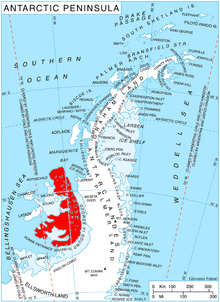
Thompson Hill is located at 69°28′54.7″S 71°20′02″W, which is 4.34 km northeast of Mount Kliment Ohridski, 8.75 km east of Mount Wilbye in Lassus Mountains, 6.93 km southeast of Mount Braun, 4.2 km west of Vola Ridge, 10.9 km west by north of Lizard Nunatak and 8.12 km northwest of Shaw Nunatak. British mapping in 1971.
Maps
- British Antarctic Territory. Scale 1:200000 topographic map. DOS 610 – W 69 70. Tolworth, UK, 1971
- Antarctic Digital Database (ADD). Scale 1:250000 topographic map of Antarctica. Scientific Committee on Antarctic Research (SCAR). Since 1993, regularly upgraded and updated
Notes
- Reference Elevation Model of Antarctica. Polar Geospatial Center. University of Minnesota, 2019
References
- Bulgarian Antarctic Gazetteer. Antarctic Place-names Commission. (details in Bulgarian, basic data in English)
- Thompson Hill. SCAR Composite Gazetteer of Antarctica
External links
- Thompson Hill. Copernix satellite image
This article includes information from the Antarctic Place-names Commission of Bulgaria which is used with permission.
This Alexander Island location article is a stub. You can help Wikipedia by expanding it. |
На других языках
[de] Thompson Hill
Der Thompson Hill (englisch; bulgarisch хълм Томпсън .mw-parser-output .Latn{font-family:"Akzidenz Grotesk","Arial","Avant Garde Gothic","Calibri","Futura","Geneva","Gill Sans","Helvetica","Lucida Grande","Lucida Sans Unicode","Lucida Grande","Stone Sans","Tahoma","Trebuchet","Univers","Verdana"}wrach Tompsan) ist ein 800 m hoher Hügel auf der Alexander-I.-Insel westlich der Antarktischen Halbinsel. Im Zentrum der Sofia Mountains ragt er 4,34 km nordöstlich des Mount Kliment Ohridski, 8,75 km östlich des Mount Wilbye, 6,93 km südöstlich des Mount Braun, 4,2 km westlich des Vola Ridge, 10,9 km westlich bis nördlich des Lizard-Nunataks und 8,12 km nordwestlich des Shaw-Nunataks auf. Das Nichols-Schneefeld liegt südöstlich, das Poste Valley nordöstlich von ihm.- [en] Thompson Hill
Другой контент может иметь иную лицензию. Перед использованием материалов сайта WikiSort.org внимательно изучите правила лицензирования конкретных элементов наполнения сайта.
WikiSort.org - проект по пересортировке и дополнению контента Википедии