geo.wikisort.org - Mountains
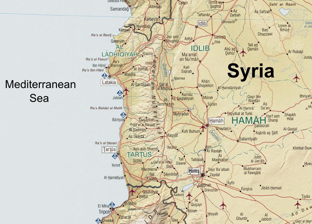
The Coastal Mountain Range (Arabic: سلسلة الجبال الساحلية Silsilat al-Jibāl as-Sāḥilīyah) also called Al-Anṣariyyah is a mountain range in northwestern Syria running north–south, parallel to the coastal plain.[1] The mountains have an average width of 32 kilometres (20 mi), and their average peak elevation is just over 1,200 metres (3,900 ft) with the highest peak, Nabi Yunis, reaching 1,562 metres (5,125 ft), east of Latakia.[1] In the north the average height declines to 900 metres (3,000 ft), and to 600 metres (2,000 ft) in the south.
| Syrian Coastal Mountain Range | |
|---|---|
| سلسلة الجبال الساحلية | |
 Coastal Mountain Range | |
| Highest point | |
| Peak | Nabi Yunis |
| Elevation | 1,562 m (5,125 ft) |
| Dimensions | |
| Length | 150 km (93 mi) |
| Geography | |
| Location | Syria |
| Range coordinates | 35.60°N 36.24°E |
Name
Classically, this range was known as the Bargylus;[2] a name mentioned by Pliny the Elder.[3] The Greek: Μπάργκυλος, romanized: Bargylus) had its roots in the name of an ancient city-kingdom called Barga most probably located in the vicinity of the mountains;[4] it was a city of the Eblaite Empire in the third millennium BC,[5] and then a vassal kingdom of the Hittites,[6] who named the mountain range after Barga.[7]
In the medieval period were known as the Jabal Bahra (جبل بهراء) after the Arab tribe of Bahra’.[8] They are also sometimes known as the Nusayriyah Mountains or the Ansarieh mountains (جبال النصيرية Jibāl an-Nuṣayriyah) or the Alawiyin Mountains (جبال العلويين Jibāl al-‘Alawīyin); both of these names refer to the Alawi ethnoreligious group which has traditionally lived there, though the former term is based on an antiquated label for the community that is now considered insulting.
Geography
The western slopes catch moisture-laden winds from the Mediterranean Sea and are thus more fertile and more heavily populated than the eastern slopes. The Orontes River flows north alongside the range on its eastern verge in the Ghab valley, a 64 kilometres (40 mi) longitudinal trench,[9] and then around the northern edge of the range to flow into the Mediterranean. South of Masyaf there is a large northeast-southwest strike-slip fault which separates An-Nusayriyah Mountain from the coastal Lebanon Mountains and the Anti-Lebanon Mountains of Lebanon, in a feature known as the Homs Gap.[1]
Between 1920 and 1936, the mountains formed parts of the eastern border of the Alawite State within the French Mandate for Syria and the Lebanon.
See also
References
- Federal Research Division, Library of Congress (2005) "Country Profile: Syria" page 5
- Hackett, Horatio B. (editor) (1870) Dr. William Smith's Dictionary of the Bible: comprising its antiquities, biography, geography, and natural history (Volume IV, Regum-Melech to Zuzims) Hurd and Houghton, New York, page 3142, OCLC 325913985
- William Smith (1857). Dictionary of Greek and Roman Geography: Iabadius-Zymethus. Little, Brown and Company. p. 1071.
- Forrer, Emil Orgetorix Gustav (1928). "Barga". In Ebeling, Erich; Meissner, Bruno (eds.). Reallexikon der Assyriologie (in German). Vol. 1. Walter de Gruyter & Co. p. 401. OCLC 718866.
- Cyrus Herzl Gordon; Gary Rendsburg; Nathan H. Winter (2002). Eblaitica: Essays on the Ebla Archives and Eblaite Language, Volume 4. p. 121. ISBN 978-1-57506-060-6.
- Gordon Douglas Young (1981). Ugarit in Retrospect: Fifty Years of Ugarit and Ugaritic. p. 227. ISBN 9780931464072.
- James Orr (1930). The International Standard Bible Encyclopaedia. Vol. 3. p. 1400.
- Salibi, Kamal (2005). A House of Many Mansions: The History of Lebanon Reconsidered. Londo: I. B. Tauris. ISBN 1860649122.
- Encyclopædia Britannica – Syria
| Authority control |
|
|---|
На других языках
[de] Dschebel Ansariye
Dschebel Ansariye, arabisch جبال الأنصارية, DMG Ǧibāl al-Anṣārīya, auch Dschebel al-Alawia, Jabal an-Nusayriyah und Jabal al-Ladhiqiyah; ist ein parallel zur Mittelmeerküste verlaufendes Bergmassiv im Westen von Syrien. Von der südlichen Fortsetzung als Libanongebirge sind die durchschnittlich 1200 Meter hohen Berggipfel durch das Tal des (südlichen) Nahr al-Kabir, des syrisch-libanesischen Grenzflusses, getrennt. An der nördlichen Absenkung verläuft die Straße zwischen der Hafenstadt Latakia und Dschisr asch-Schugur über den Bdama-Pass.- [en] Syrian Coastal Mountain Range
[fr] Montagnes des Alaouites
Le Jabâl Ansariya[1], Jabâl an-Nusayrîa[2], Jiabal al-`Alawīyin[3] ou encore Jabâl Bahrâ'[4] est un massif montagneux de Syrie constituant le prolongement septentrional du mont Liban.[it] Catena Costiera Siriana
La Catena Costiera Siriana (in arabo: سلسلة الجبال الساحلية Silsilat al-Jibāl as-Sāḥilīyah ) è una catena montuosa nel nord-ovest della Siria che si estende da nord a sud, parallelamente alla pianura costiera. [2] Le montagne hanno una larghezza media di 32 kilometri e la loro altitudine media in cresta è di poco superiore ai 1200 m s.l.m. con la vetta più alta, Nabi Yunis, che raggiunge i 1562 m s.l.m., a est di Latakia. [2] L'altezza media scende a 900 m s.l.m. nel nord, ed a 600 m s.l.m. a sud.[ru] Ансария
Ансари́я (Эн-Нусайри́я)[1][2], Дже́бель-Ансари́я[3] (араб. جبال النصيرية) — хребет в Сирии, простирающийся с севера на юг вдоль Средиземного моря, на расстоянии 20-30 км от него. Длина более 130 км, средняя ширина 32 км, средняя высота более 1200 м, самая высокая вершина Наби-Юнис имеет высоту около 1575 метров. Сложен преимущественно известняками, имеет платообразную вершинную поверхность.Другой контент может иметь иную лицензию. Перед использованием материалов сайта WikiSort.org внимательно изучите правила лицензирования конкретных элементов наполнения сайта.
WikiSort.org - проект по пересортировке и дополнению контента Википедии