geo.wikisort.org - Mountains
The Swabian-Franconian Forest (German: Schwäbisch-Fränkischen Waldberge, also Schwäbisch-Fränkischer Wald) is a mainly forested, deeply incised upland region, 1,187 km² in area and up to 586.4 m above sea level (NHN),[1] in the northeast of Baden-Württemberg. It forms natural region major unit number 108 within the Swabian Keuper-Lias Land (major unit group 10 or D58). Its name is derived from the fact that, in medieval times, the border between the duchies of Franconia and Swabia ran through this forested region. In addition, the Swabian dialect in the south transitions to the East Franconian dialect in the north here.
| Swabian-Franconian Forest | |
|---|---|
 Finsterroter lake in Naturpark Schwäbisch-Fränkischer Wald | |
| Highest point | |
| Peak | Hohe Brach |
| Elevation | 586.4 m above NHN |
| Dimensions | |
| Area | 1,187 km2 (458 sq mi) |
| Geography | |
 The natural region major unit of the Swabian-Franconian Forest
| |
| State | Baden-Württemberg, Germany |
| Range coordinates | 49°02′13″N 9°33′01″E |
| Parent range | Swabian Keuper-Lias Land |
Hill ranges and hills
The Swabian-Franconian Forest is divided clockwise (beginning roughly in the north) into the Waldenburg Hills, Mainhardt Forest, Limpurg and Ellwangen Hills, Virngrund, Murrhardt Forest, Löwenstein Hills, Heilbronn Hills and Sulm Plateau; in addition the valley of Weinsberger Tal, which lies between the last two uplands, is part of the region
The highest point of the Swabian-Franconian Forest is the Hohe Brach (586.4 m). Other high hills include the Hagberg (585.2 m), Hornberg (580.0 m), Hohenstein (572 m), Hohenberg (568.9 m), Hohentannen (565.4 m), Altenberg (564.7 m), Stocksberg (538.9 m), Flinsberg (534.8 m), Juxkopf (533.1 m) and Steinknickle (524.9 m).
Protections
Naturpark Schwäbisch-Fränkischer Wald, or Swabian-Franconian Forest Nature Park in English, is a nature park and protected area within the Swabian-Franconian Forest. The nature park covers an area of 1,270 km², including most of the Swabian-Franconian Forest, but also large areas of adjacent cultural landscapes and historical monuments.[2]
Gallery
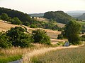 Rural cultural landscape
 Meinhardt Forest
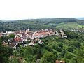 Towns and agriculture (Löwenstein)
 Large parts of the original forest has been swapped for agriculture


- Naturpark Schwäbisch-Fränkischer Wald
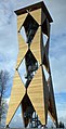 Altenbergturm, a lookout tower
 Forest stream
 Autumn scene
 Autumn in the nature park


Literature
- Paul Strähle (2006), Naturpark Schwäbisch-Fränkischer Wald : revised by Theo Müller (in German) (4th, revised and expanded ed.), Stuttgart: Theiss, ISBN 3-8062-2033-6
- LUBW Landesanstalt für Umwelt, Messungen und Naturschutz Baden-Württemberg (publ.): Naturführer Schwäbischer Wald. (Reihe Naturschutz-Spectrum. Gebiete, Vol. 29). verlag regionalkultur, Ubstadt-Weiher, 2007, ISBN 978-3-89735-507-1.
References
- Map services of the Federal Agency for Nature Conservation
- "Naturpark Schwäbisch-Fränkischer Wald" [Swabian-Franconian Forest Nature Park] (in German). Retrieved 11 September 2019.
External links
| Wikimedia Commons has media related to Swabian-Franconian Forest. |
- Natural region fact file Schwäbisch-Fränkische Waldberge (108) (N.B. the small Baden-Württemberg element of the Central Franconian Basin (113) and the Frankenhöhe (114) is integrated here.) – LUBW (pdf, 12.5 MB)
- Landscape fact file for the Swabian-Franconian Forest by the Bundesamt für Naturschutz, at bfn.de
- Detailed LUBW natural regional map at Basis by google.maps (Open "Natur und Landschaft")
- Swabian-Franconian Forest Nature Park (official homepage)
| Authority control: National libraries |
|---|
На других языках
[de] Schwäbisch-Fränkische Waldberge
Die Schwäbisch-Fränkischen Waldberge (auch Schwäbisch-Fränkischer Wald) sind ein 1187 km² großes, überwiegend bewaldetes, stark gegliedertes und bis 586,9 m ü. NHN[1] hohes Bergland im Nordosten von Baden-Württemberg. Sie bilden die naturräumliche Haupteinheit 108 innerhalb des Schwäbischen Keuper-Lias-Landes (Haupteinheitengruppe 10 bzw. D58). Der Name rührt daher, dass im Mittelalter die Grenze zwischen den Herzogtümern Franken und Schwaben dieses Waldgebiet durchschnitt. Noch heute stößt hier schwäbisches Mundartgebiet im Süden an ostfränkisches und südfränkisches im Norden.- [en] Swabian-Franconian Forest
[fr] Monts de Souabe et Franconie
Les monts de Souabe et Franconie ou la Forêt souabe-franconienne (en allemand Schwäbisch-Fränkische Waldberge ou Schwäbisch-Fränkischer Wald) est une zone montagneuse de basse altitude au nord-est du Bade-Wurtemberg. Le point culminant est la Hohe Brach avec 586 m d’altitude dans la forêt de Mainhardt. Ils font partie intégrante de la cuesta souabe, pendant allemand des cuestas de Lorraine[1]. Ils sont composés de plusieurs petits massifs de faible altitude très boisés dont la jonction est assurée par des vallons de petits cours d’eau qui entaillent plus des hauts plateaux que de vrais sommets. En raison de sa configuration géologique du Keuper[2] moyen et inférieur marqué par le grès à roseaux et la dolomie, des thalwegs torrentiels incisent les parties supérieures en formant des cascades sur rochers dénudés et des vallons en V très inaccessibles qu’on désigne localement par le terme « Klinge ».Другой контент может иметь иную лицензию. Перед использованием материалов сайта WikiSort.org внимательно изучите правила лицензирования конкретных элементов наполнения сайта.
WikiSort.org - проект по пересортировке и дополнению контента Википедии