geo.wikisort.org - Mountains
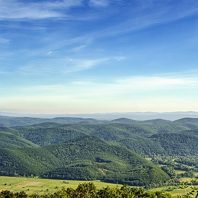
Strandzha (Bulgarian: Странджа, also transliterated as Strandja, pronounced [ˈstrand͡ʒɐ]; Turkish: Istranca [istɾand͡ʒa], or Yıldız [jɯɫdɯz]) is a mountain massif in southeastern Bulgaria and the European part of Turkey. It is in the southeastern part of the Balkans between the plains of Thrace to the west, the lowlands near Burgas to the north, and the Black Sea to the east. Its highest peak is Mahya Dağı (Bulgarian: Махиада, Mahiada) (1,031 m or 3,383 ft) in Turkey, while the highest point on Bulgarian territory is Golyamo Gradishte (Bulgarian: Голямо Градище) (710 m or 2,329 ft). The total area is approximately 10,000 km2 (3,861 sq mi).
The name of the massif allegedly derives from Istranca, the former name of the municipality of Binkılıç in Çatalca district, Istanbul province.
Geography and climate

The climate of the area is considerably influenced by the Black Sea and is predominantly humid continental in the mountains and humid subtropical at the coast. Major rivers in the area are the Veleka (147 km or 91 mi long) and the border river Rezovska (112 km or 70 mi long).
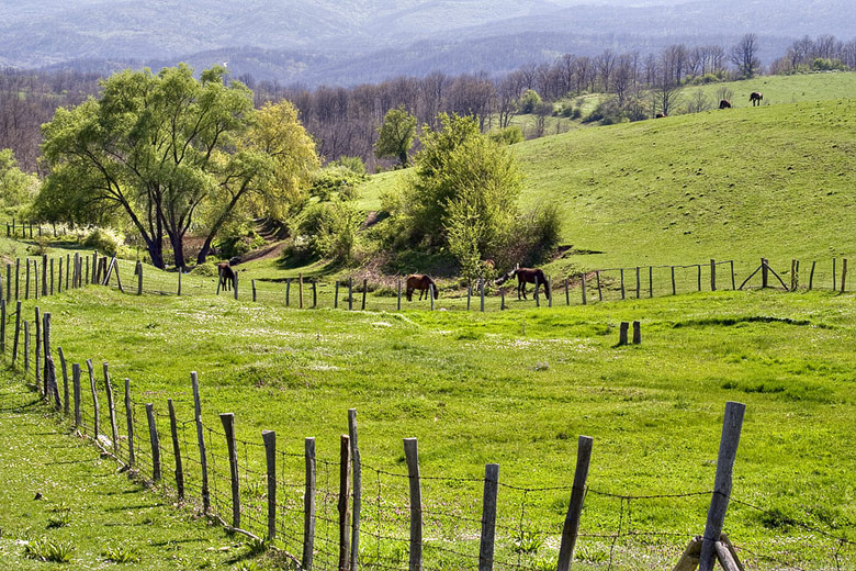
Strandzha Nature Park
Strandzha Nature Park, established in 1995 in the Bulgarian part of the massif, is the largest protected area in Bulgaria, embracing 1,161 km2 (448 sq mi), or about 1% of Bulgaria's total territory.
History and culture
Inhabited by the Thracians in antiquity, Strandzha is an area with a large concentration of ruins of Thracian sanctuaries, sacrificial altars, dolmens, and other archaeological objects.
The mountains were the site of the Bulgarian Preobrazhenie Uprising of 1903 that was crushed by Ottoman troops. The current Bulgarian-Turkish border in the region was established after the Balkan Wars of 1912-1913, when the northern part of Strandzha became part of Bulgaria.
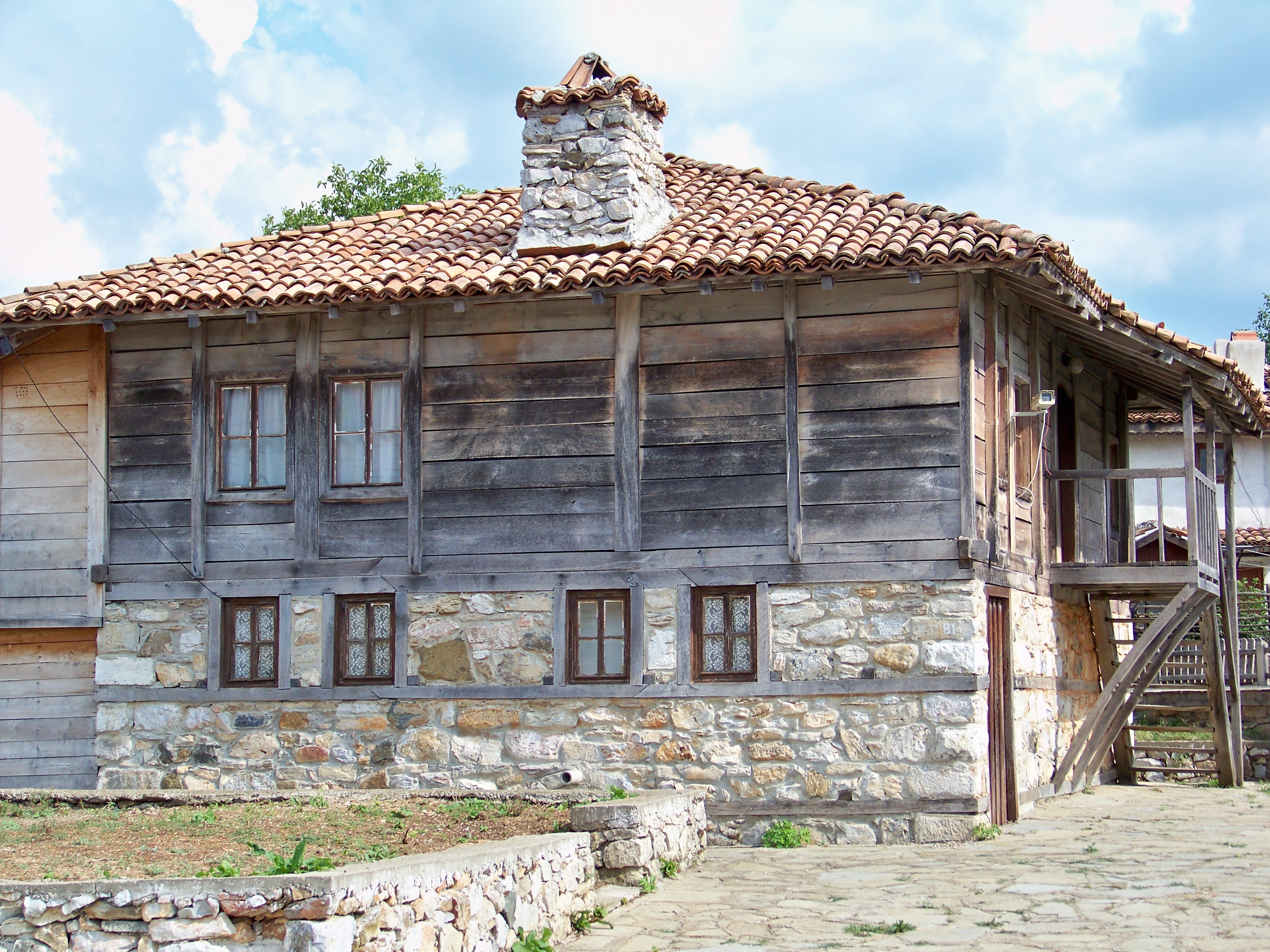
Culturally, the Bulgarian part of Strandzha is known for the specific architecture that can be observed in Malko Tarnovo, Brashlyan, and most other villages, the rich folklore and distinctive rituals, such as nestinarstvo (barefoot dancing on live embers), that preserve pagan elements.
Flora and fauna
The Strandzha Mountains have a rich and diverse flora and fauna, unique within Europe. The eastern part of Strandzha is covered by the most northwestern extent of the Euxine–Colchic deciduous forests ecoregion. 50% of Bulgaria's flora can be observed in Strandzha Nature Park and the area has 121 habitat types. In Strandzha over 600 species of invertebrates are found, as well as over 400 species of vertebrates, 41 species of freshwater fish, 10 species of amphibians, over 20 species of reptile, more than 130 species of breeding birds, and over 60 species of mammals.[1]
One of the reasons for the abundance of flora and fauna is the area's location at a bio-geographical crossroad between the European and Asian continents.
The plant communities in Strandzha developed before Europe was separated from Asia by the formation of the Bosporus Strait that now connects the Black Sea with the Mediterranean Sea. Land-ice never reached Strandzha during the ice-ages of the Pleistocene and the Holocene. This lack of glaciations helped create the circumstances in which flora characteristic for the Tertiary period on the European continent has been preserved in Strandzha.
Honour
Strandzha Glacier on Livingston Island in the South Shetland Islands, Antarctica is named after Strandzha Mountain.
References
- Kamburov, Ivan (2006). The Nature of 'Strandja' Park. Directorate of 'Strandja' Nature Park. pp. 1–22. ISBN 978-954-92093-2-7.
| Wikimedia Commons has media related to Strandzha. |
External links
- Intelligent Life magazine feature 'Forest of Eternal Return'
- The website of Strandja National Park (in Bulgarian)
- Images from Strandja
- More images from Strandja
- SNC Zlatna Strandja
- Discover Strandja (in Bulgarian, English, German, and Russian)
- Strandja.hit.bg
- Hiking in Strandzha Mountains
- StrandjaVillage.com
- General info Strandja Nature Park
- Nature in Strandja
- "Civil protests in support of Strandja Nature Park expand". Radio Bulgaria. 5 July 2007. Archived from the original on 6 November 2007. Retrieved 2007-10-03.
| Authority control: National libraries |
|---|
На других языках
[de] Strandscha
Strandscha (bulgarisch Странджа, internationale Transliteration Strandža, türkisch Yıldız Dağları oder Istranca Dağları, auch als Strandzha, Strandja oder Stranja transliteriert) ist ein Gebirge in Südosteuropa. Es erstreckt sich in Südost-Bulgarien und dem Norden der europäischen Türkei und gehört zur Landschaft Thrakien. Der Gebirgskern des sich in Nordwest-Südost-Richtung erstreckenden Gebirges setzt sich aus Gneis und Granit zusammen und ist zum Teil von Tertiärschichten überdeckt.[1]- [en] Strandzha
[es] Istranca
Istranca (en turco, Yıldız Dağları o Istranca) o Strandzha (en búlgaro, Странджа, también transliterado como Strandja o Stranja ) es un macizo montañoso en el sureste de Bulgaria y la parte europea de Turquía, en la parte sureste de los Balcanes entre las llanuras de Tracia, las tierras bajas cerca de Burgas al norte y el mar Negro al este. Su pico más alto esta en Turquía, el Mahya Dağı (en búlgaro, Махиада, Mahiada) de 1031 msnm, mientras que el punto más alto en territorio búlgaro es el Golyamo Gradishte (en búlgaro, Голямо Градище) de 710 m. La superficie total del macizo es de aproximadamente 10 000 km². El nombre del macizo supuestamente deriva de Istranca, el anterior nombre del municipio de Binkılıç en el distrito de Çatalca, en la provincia de Estambul.[fr] Strandja (massif)
Le Strandja (en bulgare : Странджа ; en grec ancien : Σκυρμιάδος όρος / Skurmiádos óros ; en turc : Istranca dağları, plus récemment Yıldız dağları) est un massif montagneux du Sud-Est de la péninsule balkanique et de l'Europe. Il est situé à cheval sur le Sud-Est de la Bulgarie et le Nord de la partie européenne de la Turquie. La plus haute montagne est le Mahiada (bulgare : Махиада, grec ancien : Μαχιάδα, turc : Mahya dağı), en Turquie, avec une altitude de 1 031 mètres.[it] Strandža
Lo Strandža (in bulgaro: Странджа, traslitterato anche come Strandzha o Strandja; in turco Yıldız Dağları o Istranca Dağları) è un massiccio montuoso sito al confine sudest della Bulgaria con la parte europea della Turchia, compreso nella parte sud dei Balcani tra le pianure della Tracia ad ovest, la pianura vicino Burgas a nord ed il Mar Nero ad est.[ru] Странджа
Иилдыз[1] (Йылдыз, тур. Yıldız Dağları [jɯɫdɯz] — «Звезда»), также Истранджа[1] (тур. Istranca Dağları [istɾand͡ʒa]), Странджа (болг. Странджа [ˈstrand͡ʒɐ], греч. Στράντζα) — горы в Турции и Болгарии. Расположены в Восточной Фракии.Другой контент может иметь иную лицензию. Перед использованием материалов сайта WikiSort.org внимательно изучите правила лицензирования конкретных элементов наполнения сайта.
WikiSort.org - проект по пересортировке и дополнению контента Википедии