geo.wikisort.org - Mountains
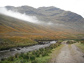
Stob a'Choin (869 m) is a mountain in the Grampian Mountains, Scotland, north of Loch Katrine in the Loch Lomond and The Trossachs National Park.
| Stob a' Choin | |
|---|---|
 Stob a'Choin from the River Larig | |
| Highest point | |
| Elevation | 869 m (2,851 ft)[1] |
| Prominence | 480 m (1,570 ft) |
| Listing | Corbett, Marilyn |
| Coordinates | 56°18′37″N 4°33′40″W |
| Geography | |
| Location | Stirling, Scotland |
| Parent range | Grampian Mountains |
| OS grid | NN417159 |
| Topo map | OS Landranger 56 |
The nearest village is Balquhidder.[2]
References
- "Stob a' Choin". hill-bagging.co.uk. Retrieved 7 May 2019.
- "walkhighlands Stob a'Choin". walkhighlands.co.uk. Retrieved 7 May 2019.
Текст в блоке "Читать" взят с сайта "Википедия" и доступен по лицензии Creative Commons Attribution-ShareAlike; в отдельных случаях могут действовать дополнительные условия.
Другой контент может иметь иную лицензию. Перед использованием материалов сайта WikiSort.org внимательно изучите правила лицензирования конкретных элементов наполнения сайта.
Другой контент может иметь иную лицензию. Перед использованием материалов сайта WikiSort.org внимательно изучите правила лицензирования конкретных элементов наполнения сайта.
2019-2025
WikiSort.org - проект по пересортировке и дополнению контента Википедии
WikiSort.org - проект по пересортировке и дополнению контента Википедии