geo.wikisort.org - Mountains
The Simien Mountains[1][2][3] (Amharic: ስሜን ተራራ or Səmen; also spelled Simen and Semien), in northern Ethiopia, north east of Gondar in Amhara region, are part of the Ethiopian Highlands. They are a World Heritage Site and include the Simien Mountains National Park. The mountains consist of plateaus separated by valleys and rising to pinnacles. The highest Ethiopian mountain is Ras Dejen at 4,550 m with the second highest peak of Kidis Yared at 4,453 m; other notable peaks include Mount Biuat at 4,437 m.


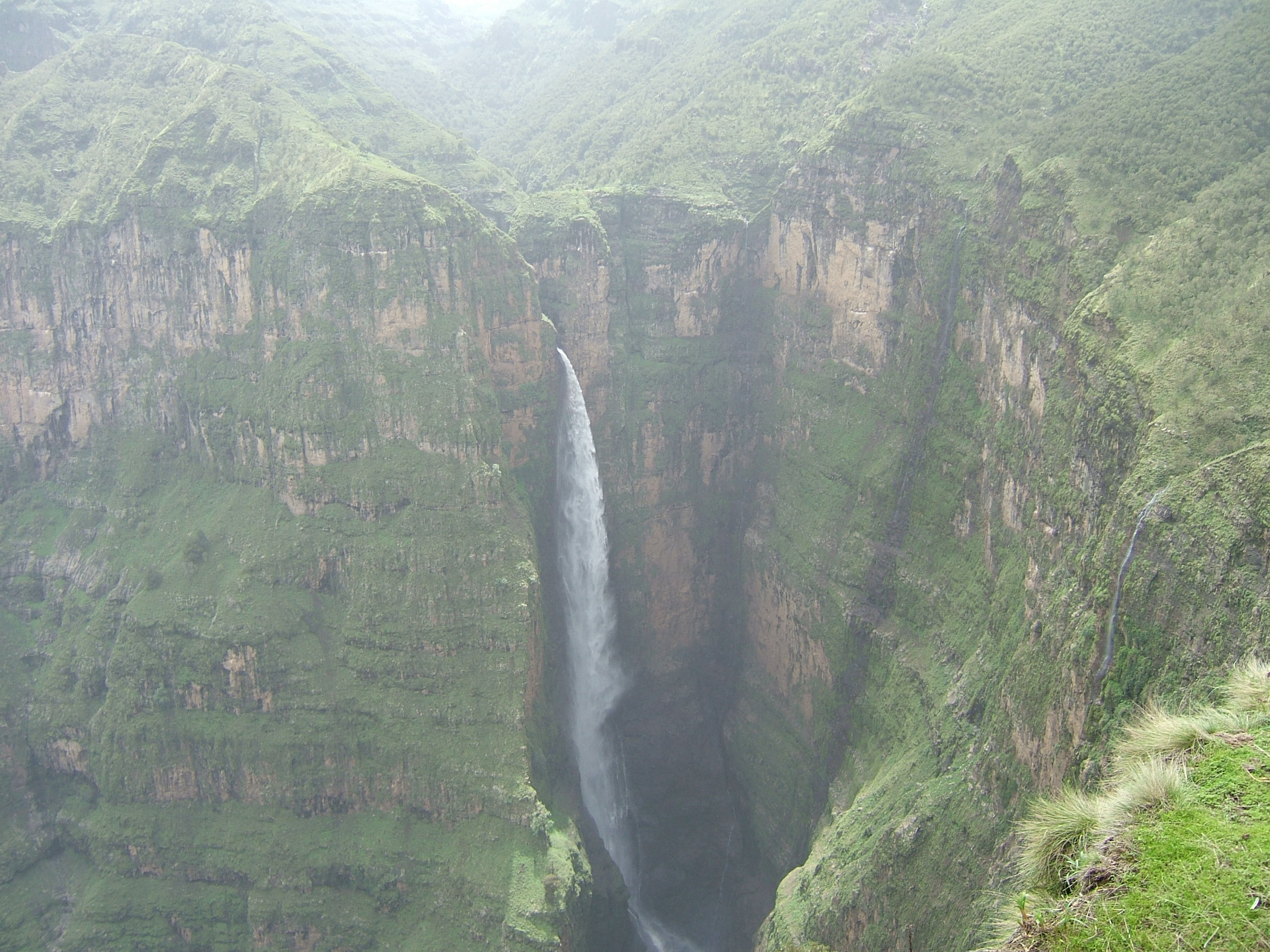

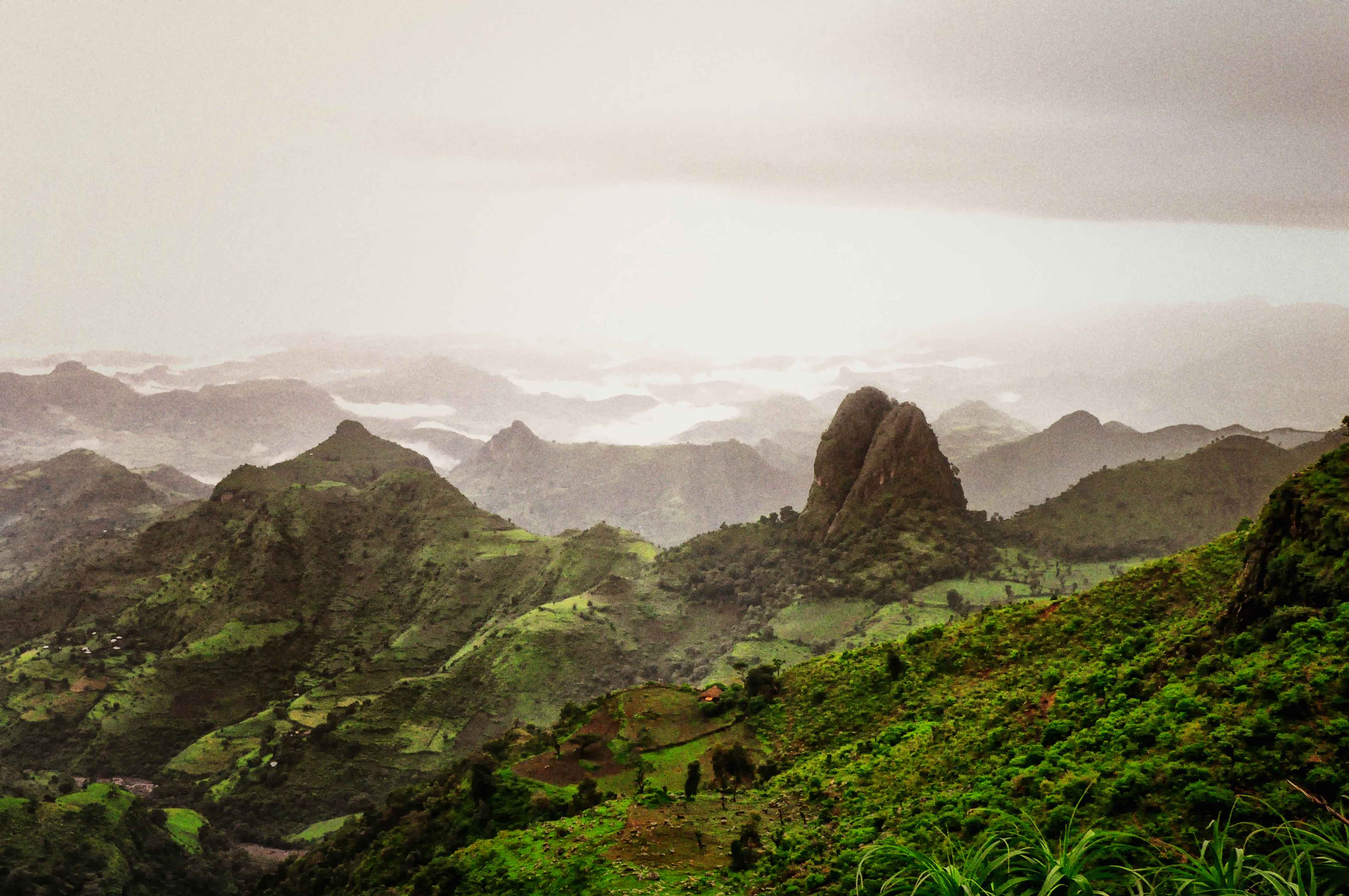
The Simien Mountains are remarkable as being one of the few spots in tropical Africa where snow regularly falls.[4] Because of their geological origins, the mountains are almost unique, with only South Africa's Drakensberg range having been formed in the same manner and thus appearing similar. Notable animals in the mountains include the walia ibex, gelada, and caracal. There are a few Ethiopian wolves.
Etymology
Although the word Semien means "north" in Amharic, according to Richard Pankhurst the ancestral form of the word actually meant "south" in Ge'ez, because the mountains lay to the south of Axum, which was at the time the hub of Ethiopian civilization. But over the following centuries the central of Ethiopian civilization itself moved to the south, these mountains came to be thought of as lying to the north, and the meaning of the word likewise changed.[dubious ][5]
Geology and landscape
This section needs additional citations for verification. (June 2017) |
The Simien Mountains were formed prior to the creation of the Rift Valley, from lava outpourings between 40 and 25 million years ago during the Oligocene period. The volcano is believed to have spread over more than 5000 m2 and resulted in a thick sequence of basaltic lava some 3,000-3,500 m thick that was deposited on Precambrian crystalline basement. The major part of the Simien Mountains consists of remnants of a Hawaiian-type shield volcano. The Kidus Yared peak is situated near the middle of the shield volcano. Ras Dejen (4,533 m), Bwahit (4,430 m) and Silki (4,420 m) were formed from the outer core of this ancient volcano.
The extreme escarpment in Simien appears to be a precondition for the formation of the extended uplift of the whole mountain massif 75 million years ago. The dramatic views are due to this volcanic activity. Especially of note is the 2,000 m high escarpment extending in a southwest to northeast axis.
There are different types of soils as a result of the difference in geological formation, glaciations, topography, and climate. Humic Andosols are the dominant soil type which is mainly found at an altitude of 3,000 m. The other types of soils are shallow Andosols, Lithosols, and Haplic Phaeozems that are mainly common in the area between 2,500 and 3,500 m. The Simien Mountains are highly eroded as a result of human land use practices and as a result of the topography of the area.
History
There is a note in Cosmas Indicopleustes' work that the Simien Mountains were a place of exile for subjects condemned to banishment by the Aksumite king.[6]
First mentioned in the Monumentum Adulitanum of the 4th century AD (which described them as "inaccessible mountains covered with snow" and where soldiers walked up to their knees in snow), the presence of snow was undeniably witnessed by the 17th century Jesuit priest Jerónimo Lobo.[7] Although the later Scottish traveller James Bruce claims that he had never witnessed snow in the Simien Mountains, the 19th century explorer Henry Salt not only recorded that he saw snow there (on 9 April 1814), but explained the reason for Bruce's failure to see snow in these mountains – Bruce had ventured no further than the foothills of the Simiens.[8]
Despite their ruggedness and altitude, the mountains are dotted with villages linked by tracks.
Folklore
An old folklore superstitions from the Semien mountains regarding certain trees called Genwarar was documented in Nathaniel Pearce's early 19th century journal. The Genwarar trees are seldom above eight feet in height, and from a distance could give the appearance or shape of a human being. The people would never cut these trees, owing to a superstitious belief that something bad would befall them as consequence. Local traditions say the trees contain evil spirits, which have been cast out of human beings, and are harmless when not disturbed, however, when a tree is cut, the spirits enter a person out of vengeance, but in general not to those who cut them down. Aside from this, the trees produces a milky substance, which is used for ink, for the purpose of writing charms, to be worn on any part of the body as a cure for those possessed by evil spirits, and to prevent their entering those who are not previously tormented with them.± The milk of the genwarar was also used in the treatment of lingering sickness.[9]
References
- "Simien National Park". UNESCO. Retrieved 13 April 2021.
part of the Simien mountain massif, which is located on the northern limit of the main Ethiopian plateau and includes the highest point in Ethiopia, Ras Dejen. The undulating plateau of the Simien mountains has over millions of years been eroded to form precipitous cliffs and deep gorges of exceptional natural beauty.
- "Welcome to the official website of Simien Mountains National Park". Simien Mountains National Park. Retrieved 13 April 2021.
The Simien Mountains National Park in Northern Ethiopia is an exotic setting with unique wildlife and breath-taking views on a landscape shaped by nature and traditional agriculture. The natural beauties of this region have always filled visitors from Ethiopia and abroad with awe.
- Pozzan, Olivia (22 September 2016). "Trekking Ethiopia's Simien Mountains". Lonely Planet. Retrieved 13 April 2021.
Due to its scope and size, the mighty mountain massif of the Simien Mountains is poetically called the ‘roof of Africa’. Ras Dashen, at 4543m, is Ethiopia’s highest peak and its crowning glory.
- Discussed further in Frederick J. Simoons, "Snow in Ethiopia: A Review of the Evidence", Geographical Review, 50 (1960), pp. 402-411.
- "Historical Notes on Books: An Early Ethiopian Map" (Capital newspaper website)
- Wolska-Conus, W., La topographie chrétienne (Paris Press univ. de France 1962)
- Donald M. Lockhart (translator), The Itinerário of Jerónimo Lobo (London: Hakluyt Society, 1984), p. 240.
- Henry Salt, A Voyage to Abyssinia and Travels into the Interior of that Country, 1814 (London: Frank Cass, 1967), p. 352.
- Pearce, Nathaniel (2014). "VI". The Life and Adventures of Nathaniel Pearce: Written by Himself, during a Residence in Abyssinia from the Years 1810–1819; Together with Mr Coffin's Account of his First Visit to Gondar. Vol. 1. Cambridge: Cambridge University Press. p. 210. ISBN 9781107450516.
External links
Simien Mountains National Park
На других языках
- [en] Simien Mountains
[es] Montañas Simen
Las montañas Simen son un sistema montañoso que se extiende al norte de Etiopía, en la región Amhara. Está ubicado en la zona de Gondar, al noreste de la ciudad homónima. Constituyen un sitio declarado Patrimonio de la Humanidad por la Unesco, e incluye además el parque nacional de Simen.[fr] Monts Simien
Les monts Simien (ስሜን (Semén) en amharique) forment une partie des plateaux d'Éthiopie dans la partie nord du pays, au nord-est de Gondar. Abritant le parc national du Simien, ils sont reconnus patrimoine mondial par l'UNESCO.[it] Monti Semien
I monti Semièn[1] sono montagne dell'Etiopia. Sono costituite da un altopiano ondulato, profondamente intersecato da valli rocciose, che a nord e a est digrada in una serie di precipizi (una sorta di muraglia ininterrotta lunga più di 40 chilometri). Gli spettacolari pinnacoli che fronteggiano i precipizi fanno sì che questo paesaggio sia stato paragonato per maestosità al Grand Canyon americano. La vetta più elevata (la quarta in Africa) è Ras Dascian (4.549 m); altri picchi importanti sono il Buait (4.437 m) e l'Abba Yared (4.460 m). I monti hanno la particolarità di essere fra i pochissimi luoghi in Africa in cui nevica regolarmente (il nome Semien, vuol dire paese del Nord[2]).[ru] Сымен (горный хребет)
Сымен (амх. ሰሜን ተራራ) — горный хребет в северной части Эфиопского нагорья к северо-востоку от Гондэра.Другой контент может иметь иную лицензию. Перед использованием материалов сайта WikiSort.org внимательно изучите правила лицензирования конкретных элементов наполнения сайта.
WikiSort.org - проект по пересортировке и дополнению контента Википедии