geo.wikisort.org - Mountains
Sierra de las Ánimas is a hill range which starts in Lavalleja Department of Uruguay and extends south into Maldonado Department.
| Sierra de las Ánimas | |
|---|---|
 Cerro Pan de Azúcar | |
| Highest point | |
| Peak | Cerro de las Ánimas |
| Elevation | 501 m (1,644 ft) |
| Coordinates | 34°48′33″S 58°15′31″W |
| Geography | |
 | |
| Country | Uruguay |
| Range coordinates | 34°36′S 55°17′W |
| Geology | |
| Age of rock | Precambrian |
| Type of rock | Granite, gneiss |
Features
Here in Maldonado Department it includes one of the highest peaks of Uruguay, the top of Cerro de las Ánimas 501 metres (1,644 ft), near the towns Gregorio Aznárez and Las Flores.
It is the only elevated landform of volcanic origin in Uruguay.
Related landform
It is a branch of the Cuchilla Grande which extends north - northeast through Treinta y Tres Department into Cerro Largo Department, and which includes secondary ranges.
See also
- Geography of Uruguay
Capital: Minas | ||
| Towns and villages | 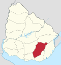 | |
| Sights |
| |
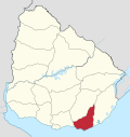
Capital: | ||
| Municipalities |
|  |
| Towns and villages |
| |
| Sights |
| |
This article about a location in Uruguay is a stub. You can help Wikipedia by expanding it. |
На других языках
[de] Sierra de las Ánimas
Die Sierra de las Ánimas ist ein Gebirge in Uruguay.- [en] Sierra de las Ánimas
[es] Sierra de las Ánimas
La Sierra de las Ánimas se constituyó varios millones de años atrás como la única de origen volcánico en territorio uruguayo, justo cuando la Cordillera de los Andes comienza a elevarse entre Argentina y Chile hasta la altura de 6.962 metros.Текст в блоке "Читать" взят с сайта "Википедия" и доступен по лицензии Creative Commons Attribution-ShareAlike; в отдельных случаях могут действовать дополнительные условия.
Другой контент может иметь иную лицензию. Перед использованием материалов сайта WikiSort.org внимательно изучите правила лицензирования конкретных элементов наполнения сайта.
Другой контент может иметь иную лицензию. Перед использованием материалов сайта WikiSort.org внимательно изучите правила лицензирования конкретных элементов наполнения сайта.
2019-2026
WikiSort.org - проект по пересортировке и дополнению контента Википедии
WikiSort.org - проект по пересортировке и дополнению контента Википедии