geo.wikisort.org - Mountains
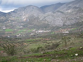
Sierra de Alhama is a mountain range of the Penibaetic System in Málaga and Granada provinces, Andalusia, Spain. Its highest point is the 1,500 m high Pico de la Torca. Other notable summits are Hoyo del Toro, 1,353 m, Cerro de Marchamonas, 1,272 m and Morrón de la Cuna 1,222 m. [1]
| Sierra de Alhama | |
|---|---|
 View of the Sierra de Alhama | |
| Highest point | |
| Peak | Pico de la Torca |
| Elevation | 1,500 m (4,900 ft) |
| Coordinates | 36°57′0″N 04°07′0″W |
| Geography | |
 Sierra de Alhama Location in Spain | |
| Location | Málaga and Granada provinces, Andalusia |
| Country | Spain |
| Parent range | Penibaetic System |
| Geology | |
| Orogeny | Alpine orogeny |
| Type of rock | Karstic |
Geography
This karstic mountain range is part of the ranges in the interior area of Axarquia. It stretches between the Sierra del Jobo and the 1,040 m high Puerto de los Alazores mountain pass in the west and the Sierra de Tejeda in the east with the corridor of Periana between them. The Guadalhorce river has its sources in this range. The Sierra de Alhama also includes the Boquete de Zafarraya an important pass at 992 m in the mountainous region of Axarquía.[2]
See also
- Baetic System
- Geology of the Iberian Peninsula
References
- Axarquia, Medio Natural Archived 2016-03-04 at the Wayback Machine
- Yus Ramos, R. et al, Por la Dorsal Bética. Centro de Desarrollo Rural (CEDER) de la Axarquía, Málaga 2007. Archived 2016-03-03 at the Wayback Machine ISBN 978-84-690-6437-5
External links
 Media related to Sierra de Alhama at Wikimedia Commons
- Hiking in Sierra de Alhama
На других языках
- [en] Sierra de Alhama
[fr] Sierra de Alhama
La Sierra de Alhama est un massif montagneux faisant partie des cordillères Bétiques au sud de l'Espagne. Elle se trouve sur les territoires des provinces de Malaga et de Grenade, dans la communauté autonome d'Andalousie. Son point culminant est le pico de la Torca à 1 500 m d'altitude.Текст в блоке "Читать" взят с сайта "Википедия" и доступен по лицензии Creative Commons Attribution-ShareAlike; в отдельных случаях могут действовать дополнительные условия.
Другой контент может иметь иную лицензию. Перед использованием материалов сайта WikiSort.org внимательно изучите правила лицензирования конкретных элементов наполнения сайта.
Другой контент может иметь иную лицензию. Перед использованием материалов сайта WikiSort.org внимательно изучите правила лицензирования конкретных элементов наполнения сайта.
2019-2025
WikiSort.org - проект по пересортировке и дополнению контента Википедии
WikiSort.org - проект по пересортировке и дополнению контента Википедии