geo.wikisort.org - Mountains
The Serra Geral (General Mountains) is a mountain range in southern Brazil, constituting the southern portion of the Serra do Mar system which runs along Brazil's southeastern coast. The Serra Geral runs parallel to the Atlantic coast in Santa Catarina and northern Rio Grande do Sul states, separating a narrow coastal plain from an interior plateau. The coastal plain is characterized by short rivers and frequent lagoons and bays, and lies within the humid tropical Serra do Mar coastal forests ecoregion.
This article does not cite any sources. (January 2008) |
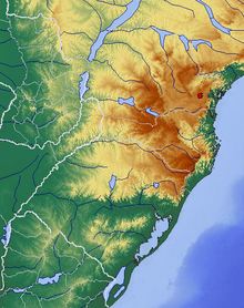
The plateau to the west of the range is drained by tributaries of the Uruguay River, including the Pelotas and Canoas, and by the Jacuí River and its tributaries, which drains south into the Lagoa dos Patos of Rio Grande do Sul.
The Serra Geral is home to Aparados da Serra National Park and Serra Geral National Park, which are notable for their enormous canyons.
The plateau is the coldest part of Brazil, with frequent frosts and yearly snow, being home to the montane Araucaria moist forests. It is on Santa Catarina's portion of the Serra Geral where Brazil's coldest towns, Urubici, Urupema, São Joaquim and Bom Jardim da Serra, are located.
 | This geographical article relating to Rio Grande do Sul is a stub. You can help Wikipedia by expanding it. |
На других языках
- [en] Serra Geral
[es] Sierra Geral
La sierra Geral es una formación rocosa que tiene sus orígenes en el Paraguay, específicamente en la cordillera del Mbaracayú, formando las elevaciones de los estados brasileños de Paraná (que corta diagonalmente), Santa Catarina (del que divide el litoral del interior) y Río Grande del Sur, donde lo mismo que en Uruguay se caracteriza por cuchillas y campos llanos, pero que sin embargo las suaves ondulaciones forman gruesos muros y rocas basálticas. Forma también las cumbres y colinas de la Mesopotamia Argentina (Provincia de Misiones). Una parte está protegido dentro del Parque nacional de la Sierra Geral.[fr] Serra Geral
La serra Geral est une formation montagneuse du Sud du Brésil. Elle coupe l'État de Santa Catarina du nord au sud. Elle constitue la partie la plus méridionale de la serra do Mar.[it] Serra Geral
La Serra Geral è una catena montuosa del Brasile, che costituisce il tratto meridionale della Serra do Mar che corre lungo la costa del Brasile da nord a sud. La Serra Geral corre parallela alla costa dell'oceano Atlantico dallo Stato di Santa Catarina a quello di Rio Grande do Sul, separando una stretta lingua di terra pianeggiante dall'altopiano. La zona costiera pianeggiante è punteggiata da brevi fiumi e frequenti lagune e baie, e si trova all'interno della zona tropicale umida.Другой контент может иметь иную лицензию. Перед использованием материалов сайта WikiSort.org внимательно изучите правила лицензирования конкретных элементов наполнения сайта.
WikiSort.org - проект по пересортировке и дополнению контента Википедии