geo.wikisort.org - Mountains
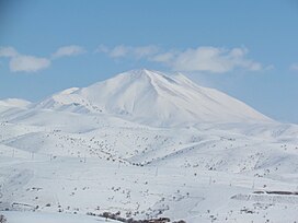
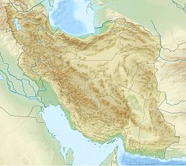
Sahand (Persian: سهند), is a massive, heavily eroded stratovolcano in East Azerbaijan Province, northwestern Iran. At 3,707 m (12,162 ft), it is the highest mountain in the province of East Azarbaijan.
| Sahand | |
|---|---|
 | |
| Highest point | |
| Elevation | 3,707 m (12,162 ft)[1] |
| Prominence | 1,826 m (5,991 ft)[1] |
| Listing | Ultra |
| Coordinates | 37°43′51″N 46°30′00″E[1] |
| Geography | |
| Location | East Azarbaijan, Iran |
| Geology | |
| Age of rock | 12–0.14 million years |
| Mountain type | Stratovolcano |
| Last eruption | Unknown |
Sahand is one of the highest mountains in Iranian Azerbaijan, in addition to being an important dormant volcano in the country.[2] The Sahand mountains are directly south of Tabriz, the highest peak of which is Kamal at an elevation of 3,707 m (12,162 ft). Approximately 17 peaks can be accounted for as being over 3,000 m (9,843 ft) in height. Due to the presence of a variety of flora and fauna, the Sahand mountains are known as the bride of mountains in Iran.[3]
The absolute dating of Sahand rocks indicates that this volcano has been sporadically active from 12 million years ago up to almost 0.14 million years ago. Sahand is made chiefly of dacite and associated felsic rocks.
Winter sports
Sahand Ski Resort is on the northern foothills of the mountain and near the city of Tabriz. In the complex the Sahand Skiing Stadium has a 1200 meters length ski area and skiing and snowboarding is practiced in the resort. The snow sculpture competition, which runs once a year at mid-winter in the stadium, is a famous entertainment that attracts spectators and competitors from all over the country.
See also
- List of volcanoes in Iran
- Sahand University of Technology
- List of Ultras of West Asia
- Kandovan rock dwellings
References
- "Iran: 54 Mountain Summits with Prominence of 1,500 meters or greater". Peaklist.org. Retrieved 2014-05-25.
- Scheffel, Richard L.; Wernet, Susan J., eds. (1980). Natural Wonders of the World. United States of America: Reader's Digest Association, Inc. p. 330. ISBN 0-89577-087-3.
- سیما, IRIB NEWS AGENCY | خبرگزاری صدا و (July 31, 2018). "وضع بحرانی عروس کوههای ایران در آذربایجان شرقی". fa (in Persian). Retrieved 2021-11-19.
- "Sahand". Global Volcanism Program. Smithsonian Institution.
На других языках
[de] Kuh-e Sahand
Der Kuh-e Sahand (persisch سهند) ist ein 3710 m hoher, inaktiver Schichtvulkan. Er liegt 60 km östlich des Urmia-Sees und 40 km südsüdöstlich von Täbris im Iran. Er gehört zu den höchsten Bergen in der Region Āzarbāydschān. Der höchste Gipfel des Massivs ist der Jam Daqi, etwa 17 Bergspitzen haben eine Höhe über 3000 m. Im Winter ist das Massiv schneebedeckt, es gibt eine Wintersportstation.- [en] Sahand
[fr] Sahand
Le Sahand (en persan سهند) est le plus haut sommet de la province d'Azerbaïdjan oriental en Iran.[it] Sahand
Il Sahand (in persiano سهند), è un enorme stratovulcano fortemente eroso nella provincia dell'Azerbaigian orientale, nell'Iran nordoccidentale. A 3 707 m (12 162 ft), è la montagna più alta della provincia dell'Azerbaigian orientale.[ru] Сехенд
Сехенд[2] (Сахе́нд[3], Саханд, перс. سهند, азерб. Səhənd) — вулканический массив на северо-западе Ирана. Высшая точка — гора Херем-Даг[1][2] (Харамдаг[3]), высота — 3710 м[1] (3707 м[2][3])[4], которая имеет серьезно эродированную вершину. Сехенд расположен в 40 км к югу от Тебриза[4].Другой контент может иметь иную лицензию. Перед использованием материалов сайта WikiSort.org внимательно изучите правила лицензирования конкретных элементов наполнения сайта.
WikiSort.org - проект по пересортировке и дополнению контента Википедии
