geo.wikisort.org - Mountains
Roztocze (Ukrainian: Розточчя, Roztochia) is a range of hills in east-central Poland and western Ukraine which rises from the Lublin Upland and extends southeastward through Solska Forest and across the border into Ukrainian Podolia. Low and rolling, the range is approximately 180 km long and 14 km wide. Its highest peak within Poland is Wielki Dział at 390 meters, while in Ukraine it is Vysokyi Zamok (Lviv High Castle) at 409 m. In Poland Roztocze lies in the Lublin and Podkarpackie voivodships, while the portion in Ukraine extends all the way to the outskirts of Lviv. In 2011 UNESCO established the Roztochya Biosphere Reserve. The Polish portion of the range makes up the Roztocze National Park.

Inhabitation
Main cities and towns of the Roztocze range include: Biłgoraj, Hrubieszów, Janów Lubelski, Józefów, Krasnobród, Kraśnik, Lubaczów, Narol, Nemyriv, Szczebrzeszyn, Tomaszów Lubelski, Yavoriv, Zamość, Zhovkva, and Zwierzyniec.
Points of interest in Roztocze region
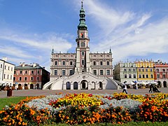 City Hall in Zamość, Poland
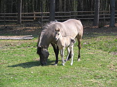 Polish ponies in the Roztocze National Park, Poland
 A pond with a church on an island, Zwierzyniec.
 Echo artificial lake in Zwierzyniec, Poland
 The Zwierzyniec Brewery building in Zwierzyniec, Poland
 Head office of the Roztocze National Park Management in Zwierzyniec, Poland
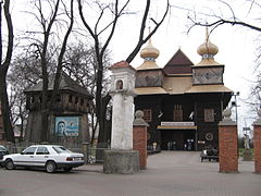 An Eastern Orthodox church in Tomaszów Lubelski, Poland, now a Catholic church.
 Catholic church in Łosiniec, Poland
 Kościuszko square in Szczebrzeszyn, Poland.
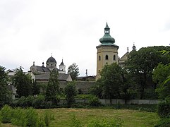 View of Zhovkva, Ukraine


References
- Information about the region from www.roztocze.com
- Information service about Roztocze (in Polish)
- Information service and photo gallery about Roztocze (in Polish)
- Roztocze landscapes - Fine Art Photography by Tomasz Dziubinski
- Roztocze landscapes - Photography by Jola Dziubinska
- Roztocze architecture - Fine Art Photography by Tomasz Dziubinski
- Roztocze places - Photography by Jola Dziubinska
- Roztocze places - Photography by mojeroztocze.pl
- Ukrainian Roztochia
- UNESCO Biosphere in 2011
Authority control | |
|---|---|
| General |
|
| National libraries | |
This article about a location in Lviv Oblast is a stub. You can help Wikipedia by expanding it. |
This Podkarpackie Voivodeship location article is a stub. You can help Wikipedia by expanding it. |
This Lublin Voivodeship location article is a stub. You can help Wikipedia by expanding it. |
На других языках
[de] Roztocze
Roztocze (ukrainisch Розточчя .mw-parser-output .Latn{font-family:"Akzidenz Grotesk","Arial","Avant Garde Gothic","Calibri","Futura","Geneva","Gill Sans","Helvetica","Lucida Grande","Lucida Sans Unicode","Lucida Grande","Stone Sans","Tahoma","Trebuchet","Univers","Verdana"}Rostotschtschja) ist eine wellige Hügelkette im südöstlichen Polen und in der westlichen Ukraine. Sie besteht aus kalkigem Sandstein und Kalkstein, der sich in der Kreidezeit bildete und sich von der Lubliner Hochebene aus südöstlich durch die Soska-Wildnis bis ins ukrainische Podolien erstreckt. Insgesamt ist sie etwa 180 km lang und 12 bis 32 km breit. Die höchste Erhebung in Polen hat 390 m, in der Ukraine 409 m. Auf polnischem Boden liegt Roztocze in den Woiwodschaften Lublin und Karpatenvorland, auf ukrainischem Gebiet erstreckt sich die Kette bis an den Stadtrand von Lwiw.- [en] Roztocze
[it] Roztocze
Il Roztocze (in ucraino Розточчя, Roztochia) è una regione collinare che si estende attraverso la Polonia centro-orientale e l'Ucraina occidentale.[ru] Розточе
Розто́че[1], Росточье, Расточье[2] (укр. Розточчя, польск. Roztocze) — суженная холмистая гряда 15—20 километров шириной и до 400 метров высотой, которая тянется в направлении от Львова (Украина) на северо-запад к Томашуву, Щебжешину и Краснику (Польша). Над близлежащими равнинами — Надсанской низменностью на юго-западе и Надбужанской котловиной на северо-востоке Розточе поднимается на 100—150 м; на северо-западе оно соединяется с Холмской и Люблинской возвышенностями.Другой контент может иметь иную лицензию. Перед использованием материалов сайта WikiSort.org внимательно изучите правила лицензирования конкретных элементов наполнения сайта.
WikiSort.org - проект по пересортировке и дополнению контента Википедии