geo.wikisort.org - Mountains
Razoredge Mountain (8,570 feet (2,612 m)) is located in the Lewis Range, Glacier National Park in the U.S. state of Montana.[3]
| Razoredge Mountain | |
|---|---|
 Aerial view of north aspect in foreground right | |
| Highest point | |
| Elevation | 8,570 ft (2,610 m)[1] NAVD 88 |
| Prominence | 810 ft (250 m)[1] |
| Coordinates | 48°33′24″N 113°30′58″W[2] |
| Geography | |
 Razoredge Mountain Location in Montana  Razoredge Mountain Location in the United States | |
| Location | Flathead County, Montana, U.S. |
| Parent range | Lewis Range |
| Topo map | USGS Mount Stimson, MT |
Geology
Like other mountains in Glacier National Park, Razoredge Mountain is composed of sedimentary rock laid down during the Precambrian to Jurassic periods. Formed in shallow seas, this sedimentary rock was initially uplifted beginning 170 million years ago when the Lewis Overthrust fault pushed an enormous slab of precambrian rocks 3 mi (4.8 km) thick, 50 miles (80 km) wide and 160 miles (260 km) long over younger rock of the cretaceous period.[4]
Climate
According to the Köppen climate classification system, Razoredge Mountain is located in an alpine subarctic climate zone with long, cold, snowy winters, and cool to warm summers.[5] Winter temperatures can drop below −10 °F with wind chill factors below −30 °F. Due to its altitude, it receives precipitation all year, as snow in winter, and as thunderstorms in summer.
Gallery
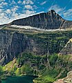 Northeast aspect above Medicine Grizzly Lake
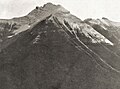 West aspect, 1914


See also
- Mountains and mountain ranges of Glacier National Park (U.S.)
References
- "Razoredge Mountain, Montana". Peakbagger.com. Retrieved January 16, 2019.
- "Razoredge Mountain". Geographic Names Information System. United States Geological Survey. Retrieved January 16, 2019.
- Mount Stimson, MT (Map). TopoQwest (United States Geological Survey Maps). Retrieved January 16, 2019.
- Gadd, Ben (2008). "Geology of the Rocky Mountains and Columbias".
{{cite journal}}: Cite journal requires|journal=(help) - Peel, M. C.; Finlayson, B. L.; McMahon, T. A. (2007). "Updated world map of the Köppen−Geiger climate classification". Hydrol. Earth Syst. Sci. 11. ISSN 1027-5606.
This Flathead County, Montana state location article is a stub. You can help Wikipedia by expanding it. |
Другой контент может иметь иную лицензию. Перед использованием материалов сайта WikiSort.org внимательно изучите правила лицензирования конкретных элементов наполнения сайта.
WikiSort.org - проект по пересортировке и дополнению контента Википедии