geo.wikisort.org - Mountains
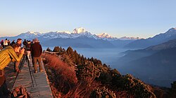
Poon Hill (पून हिल) is a hill station overlooking the Annapurna Massif range and Dhaulagiri mountain range, located on border of Myagdi District and Kaski District in Gandaki Province of Nepal. This lookout is the key viewpoint in the Ghorepani Poon Hill trek. Mountains such as an Annapurna 8,091m, Dhaulagiri 8,127, Annapurna South 7,219 Meter, Machapuchare 6,993 Meter, Hinchuli, Annapurna III, Dhampus peak, Dhulagiri II, and many other tall peaks can be seen from here.[1]
Poon Hill
पून हिल | |
|---|---|
Viewpoint | |
 | |
 Poon Hill Location in Nepal  Poon Hill Poon Hill (Nepal) | |
| Coordinates: 28.4000425°N 83.6895402°E | |
| Country | |
| Province | Gandaki Province |
| District | Myagdi District |
| Elevation | 3,210 m (10,530 ft) |
| Time zone | UTC+5:45 (Nepal Time) |
Poon Hill is located 270 km west from Kathmandu (The capital of Nepal). The hike to Poon Hill from Pokhara takes 2–3 days.[2] The Poon Hill viewpoint is on the way to Annapurna Sanctuary which lies in the centre of Annapurna Conservation Area. Trekkers need to obtain an ACCAP Permit from Kathmandu or Pokhara in order to complete this hike.[citation needed]

List of mountains seen from Poon Hill
Some of the peaks which are visible from the top of Poon Hill are listed below.
| Peak | elevation |
|---|---|
| Dhaulagiri | 8,167 m (26,795 ft) |
| Annapurna I | 8,091 m (26,545 ft) |
| Annapurna South | 7,219 m (23,684 ft) |
| Machapuchare | 6,993 m (22,943 ft) |
| Annapurna II | 7,937 m (26,040 ft) |
| Annapurna III | 7,555 m (24,787 ft) |
| Gangapurna | 7,455 m (24,459 ft) |
| Tukuche peak | 6,920 m (22,700 ft) |
| Dhampus peak | 6,012 m (19,724 ft) |
| Hiunchuli | 6,441 m (21,132 ft) |
| Gurja Himal | 7,193 m (23,599 ft) |
| Nilgiri Himal | 7,061 m (23,166 ft) |
Gallery
- View from Sunny Hotel
- on the way to Tadapani
- Poon Hill board
- Excited man pointing mountain
- Dhaulagiri 8167 Meter
- Panorama from poon hill
- Dawn at Poon Hill station, 3210m
References
- "Mountain from Poon Hill". Retrieved 2019-08-18.
- "Poon Hill trek location". Retrieved 2019-08-27.
External links
![]() Media related to Poon Hill at Wikimedia Commons
Media related to Poon Hill at Wikimedia Commons
На других языках
[de] Poon Hill
Poon Hill ist ein 3210 m hoher Berg in der Nähe von Ghorepani auf dem Poon Hill Treck in der Dhaulagiri-Zone von Nord-Zentral-Nepal. Viele Wanderer übernachten in Ghorepani, um frühmorgens den Sonnenaufgang zu beobachten und das Bergpanorama zu sehen.[1]- [en] Poon Hill
Другой контент может иметь иную лицензию. Перед использованием материалов сайта WikiSort.org внимательно изучите правила лицензирования конкретных элементов наполнения сайта.
WikiSort.org - проект по пересортировке и дополнению контента Википедии


