geo.wikisort.org - Mountains
Pollux Temple is a 6,251-foot-elevation (1,905 meter) summit in the Grand Canyon, in Coconino County of northern Arizona, US.[2] It is situated ten miles northwest of Grand Canyon Village, and less than one mile northeast of Jicarilla Point. Castor Temple is one mile northwest, and Diana Temple is one mile southeast. Topographic relief is significant as Pollux Temple rises nearly 4,000 feet (1,220 meters) above the Colorado River in less than two miles. Pollux Temple is named for Pollux, the divine son of Zeus according to Greek mythology.[4] Clarence Dutton began the practice of naming geographical features in the Grand Canyon after mythological deities.[5] According to the Köppen climate classification system, Pollux Temple is located in a Cold semi-arid climate zone.[6]
| Pollux Temple | |
|---|---|
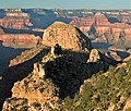
 Northeast aspect, from Tonto Trail | |
| Highest point | |
| Elevation | 6,251 ft (1,905 m)[1] |
| Prominence | 762 ft (232 m)[1] |
| Parent peak | Diana Temple (6,683 ft)[1] |
| Isolation | 1.91 mi (3.07 km)[1] |
| Coordinates | 36°07′14″N 112°18′09″W[2] |
| Geography | |
 Pollux Temple Location in Arizona  Pollux Temple Pollux Temple (the United States) | |
| Location | Grand Canyon National Park Coconino County, Arizona, US |
| Parent range | Coconino Plateau Colorado Plateau |
| Topo map | USGS Piute Point |
| Geology | |
| Type of rock | limestone, sandstone, mudstone |
| Climbing | |
| First ascent | March 1969 by Alan Doty[3] |
| Easiest route | class 4 climbing[1] |
Geology
The top of Pollux Temple is composed of Permian Toroweap Formation overlaying cream-colored, cliff-forming, Permian Coconino Sandstone.[7] The sandstone, which is the third-youngest of the strata in the Grand Canyon, was deposited 265 million years ago as sand dunes. Below the Coconino Sandstone is reddish, slope-forming, Permian Hermit Formation, which in turn overlays the Pennsylvanian-Permian Supai Group.[8] Further down are strata of the conspicuous cliff-forming Mississippian Redwall Limestone, the Cambrian Tonto Group, and finally granite of the Paleoproterozoic Vishnu Basement Rocks at river level in Granite Gorge. Precipitation runoff from Pollux Temple drains north to the Colorado River via Agate and Sapphire Canyons.
Gallery
 Pollux Temple from Jicarilla Point. (Mencius Temple in upper right)
 Aerial of Pollux Temple centered, casting shadow onto Castor Temple (upper left)
 Pollux Temple (upper left), with Sapphire Canyon, from Tonto Trail
 Pollux Temple centered in distance, from Point Sublime.
Artwork by William Henry Holmes.


See also
- Geology of the Grand Canyon area
- Scorpion Ridge
References
- "Pollux Temple – 6,251' AZ". Lists of John. Retrieved 2021-01-12.
- "Pollux Temple". Geographic Names Information System. United States Geological Survey. Retrieved 2021-01-12.
- Todd R. Berger, Reflections of Grand Canyon Historians: Ideas, Arguments and First-Person Accounts, 2nd edition, 2008, Grand Canyon Association Publisher, ISBN 978-1934656006, page 197.
- N.H. Darton, Story of the Grand Canyon of Arizona, 1917, page 80.
- Randy Moore and Kara Felicia Witt, The Grand Canyon: An Encyclopedia of Geography, History, and Culture, 2018, ABC-CLIO Publisher, page 151.
- Peel, M. C.; Finlayson, B. L.; McMahon, T. A. (2007). "Updated world map of the Köppen−Geiger climate classification". Hydrol. Earth Syst. Sci. 11. ISSN 1027-5606.
- N.H. Darton, Story of the Grand Canyon of Arizona, 1917, page 67.
- William Kenneth Hamblin, Anatomy of the Grand Canyon: Panoramas of the Canyon's Geology, 2008, Grand Canyon Association Publisher, ISBN 9781934656013.
External links
- Weather forecast: National Weather Service
- Pollux Temple from Piute Point: Flickr photo
- Pollux Temple photo by Harvey Butchart
Другой контент может иметь иную лицензию. Перед использованием материалов сайта WikiSort.org внимательно изучите правила лицензирования конкретных элементов наполнения сайта.
WikiSort.org - проект по пересортировке и дополнению контента Википедии