geo.wikisort.org - Mountains
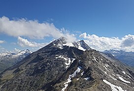
Piz Timun (also known as Pizzo d'Emet) is a mountain of the Oberhalbstein Range, located on the border between Italy and Switzerland. On its eastern side it overlooks the artificial lake Lago di Lei.
| Piz Timun | |
|---|---|
| Pizzo d'Emet | |
 Piz Timun (peak at the back of the ridge) | |
| Highest point | |
| Elevation | 3,209 m (10,528 ft) |
| Prominence | 823 m (2,700 ft)[1] |
| Parent peak | Piz Platta |
| Isolation | 10.2 km (6.3 mi)[2] |
| Listing | Alpine mountains above 3000 m |
| Coordinates | 46°28′01″N 9°24′34″E |
| Geography | |
 Piz Timun Location in the Alps | |
| Location | Lombardy, Italy Graubünden, Switzerland |
| Parent range | Oberhalbstein Range |
See also
- List of mountains of Graubünden
- List of most isolated mountains of Switzerland
References
- Retrieved from the Swisstopo topographic maps (1:25,000). The key col is the Passo di Angeloga (2,386 m).
- Retrieved from Google Earth. The nearest point of higher elevation is east of Pizzo Tambo.
External links
На других языках
[de] Piz Timun
Der Piz Timun (rätoromanisch vom lateinischen temone für ‚Deichsel‘[1]) oder Pizzo di Emet (wahrscheinlich Ableitung vom romanischen gliemat, emat für ‚Bodenbalken‘, ‚Schwelle‘, möglich, jedoch weniger sicher, Ableitung vom lateinischen intimus für ‚innerst‘[2]) ist ein Berg östlich von Montespluga und westlich vom Lago di Lei auf der Grenze zwischen dem Schweizer Kanton Graubünden und der italienischen Provinz Sondrio mit einer Höhe von 3211 m ü. M. Auf dem höchsten Punkt befindet sich das Signal der italienischen Vermessung.- [en] Piz Timun
[it] Piz Timun
Il Piz Timun (3.209 m s.l.m. - detto anche Pizzo d'Emet) è una montagna delle Alpi del Platta nelle Alpi Retiche occidentali.Текст в блоке "Читать" взят с сайта "Википедия" и доступен по лицензии Creative Commons Attribution-ShareAlike; в отдельных случаях могут действовать дополнительные условия.
Другой контент может иметь иную лицензию. Перед использованием материалов сайта WikiSort.org внимательно изучите правила лицензирования конкретных элементов наполнения сайта.
Другой контент может иметь иную лицензию. Перед использованием материалов сайта WikiSort.org внимательно изучите правила лицензирования конкретных элементов наполнения сайта.
2019-2025
WikiSort.org - проект по пересортировке и дополнению контента Википедии
WikiSort.org - проект по пересортировке и дополнению контента Википедии