geo.wikisort.org - Mountains
Piz Linard is a pyramid-shaped mountain of the Swiss Alps. At 3,410 m it is the highest peak of the Silvretta mountain range.
| Piz Linard | |
|---|---|
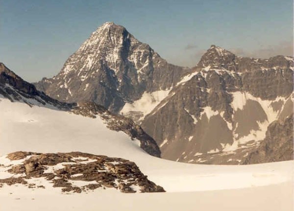
 View of Piz Linard from the Engadine valley (south) | |
| Highest point | |
| Elevation | 3,410 m (11,190 ft) |
| Prominence | 1,027 m (3,369 ft)[1] |
| Parent peak | Piz Kesch |
| Isolation | 24.9 km (15.5 mi)[2] |
| Listing | List of mountains of Switzerland, Alpine mountains above 3000 m |
| Coordinates | 46°47′56″N 10°04′17″E |
| Geography | |
 Piz Linard Location in Switzerland | |
| Location | Graubünden, Switzerland |
| Parent range | Silvretta Alps |
| Climbing | |
| First ascent | August 1, 1835 by Oswald Heer and Johann Madutz |
| Easiest route | Scramble |
It was first climbed on August 1, 1835, by the geologist and naturalist Oswald Heer led by Johann Madutz.
There is a legend that a man of name "Chounard" reached the summit in 1572 carrying a large golden cross, however the cross has never been found.[3][4]
Piz Linard is located between the valleys of Val Lavinuoz (east) and Val Saglains (west), both part of the basin of the Inn river in the Engadine valley.
See also
- List of most isolated mountains of Switzerland
References
- Retrieved from the Swisstopo maps. The key col is the Albula Pass (2,383 m).
- Retrieved from Google Earth. The nearest point of higher elevation is Piz Kesch.
- "Piz Linard". PeakVisor. Retrieved 2021-05-12.
- Krauß, Martin. Der Träger war immer schon vorher da - Die Geschichte des Wanderns und Bergsteigens in den Alpen. Munich: Carl Hanser Verlag. ISBN 978-3-312-00558-1.
External links
| Wikimedia Commons has media related to Piz Linard. |
| Authority control |
|
|---|
This article about a mountain, mountain range, or peak located in Graubünden is a stub. You can help Wikipedia by expanding it. |
На других языках
[de] Piz Linard
Der Piz Linard ist ein 3410 m ü. M. hoher Berg in den Rätischen Alpen in der Schweiz.[1] Damit ist er der höchste Berg der Silvretta. Er überragt die Ortschaft Lavin im Unterengadin um ca. 2000 m und gilt dadurch als deren Wahrzeichen. Im Atlas Suisse (1802) wurde er noch als "Selvreta M"(ons) bezeichnet.- [en] Piz Linard
[fr] Piz Linard
Le Piz Linard est un sommet des Alpes, à 3 410 m, point culminant du massif de Silvretta, en Suisse (canton des Grisons).[it] Piz Linard
Il Piz Linard (3.411 m s.l.m. - in italiano Pizzo Linard) è una cima del Gruppo del Silvretta nelle Alpi Retiche occidentali. È situata in Svizzera e sovrasta il villaggio di Lavin, posto nella Bassa Engadina.Текст в блоке "Читать" взят с сайта "Википедия" и доступен по лицензии Creative Commons Attribution-ShareAlike; в отдельных случаях могут действовать дополнительные условия.
Другой контент может иметь иную лицензию. Перед использованием материалов сайта WikiSort.org внимательно изучите правила лицензирования конкретных элементов наполнения сайта.
Другой контент может иметь иную лицензию. Перед использованием материалов сайта WikiSort.org внимательно изучите правила лицензирования конкретных элементов наполнения сайта.
2019-2026
WikiSort.org - проект по пересортировке и дополнению контента Википедии
WikiSort.org - проект по пересортировке и дополнению контента Википедии