geo.wikisort.org - Mountains
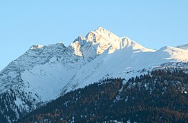
Piz Fess is a mountain of the Lepontine Alps, situated between the Val Lumnezia and Safiental in the canton of Graubünden. Piz Fess is the culminating point of the Signina range (Romansh: Cadeina dil Signina).
| Piz Fess | |
|---|---|
 View from Laax (north side) | |
| Highest point | |
| Elevation | 2,880 m (9,450 ft) |
| Prominence | 501 m (1,644 ft) [1] |
| Parent peak | Rheinwaldhorn |
| Isolation | 9.7 km (6.0 mi) |
| Coordinates | 46°43′40.9″N 9°17′22.7″E |
| Geography | |
| Location | Graubünden, Switzerland |
| Parent range | Lepontine Alps |
| Climbing | |
| First ascent | 10 August 1895 by Karl Viescher, Wieland Wieland and J. Christoffel.[2] |
The mountain has two summits, a gentle summit named the Guter Fess ("Good Fess"; 2,874 m) and a not so gentle one named Böser Fess ("Angry Fess"; 2,880 m). In 1894 the pinnacle was still described as unclimbable, but the next summer Karl Viescher from Basel and the local guides Wieland Wieland and J. Christoffel reached the sharp summit.[2]

References
- Swisstopo map
- W. Deriehsweiler, Das Safiental, Yearbook of the Swiss Alpin Club, 1919, p. 111
External links
На других языках
[de] Piz Fess
Der Piz Fess ist der höchste Gipfel der Signina-Gruppe in den Adula-Alpen in der Schweiz und steht am südlichen Ende einer Hochebene, des Schneebodens. Östlich wird diese begrenzt durch das Oberhorn (2796 m) und nördlich durch den Piz Riein (2752 m). Am Piz Fess fallen Wände steil ins Safiental ab, steile Schutthalden in Richtung Riein.- [en] Piz Fess
Текст в блоке "Читать" взят с сайта "Википедия" и доступен по лицензии Creative Commons Attribution-ShareAlike; в отдельных случаях могут действовать дополнительные условия.
Другой контент может иметь иную лицензию. Перед использованием материалов сайта WikiSort.org внимательно изучите правила лицензирования конкретных элементов наполнения сайта.
Другой контент может иметь иную лицензию. Перед использованием материалов сайта WikiSort.org внимательно изучите правила лицензирования конкретных элементов наполнения сайта.
2019-2025
WikiSort.org - проект по пересортировке и дополнению контента Википедии
WikiSort.org - проект по пересортировке и дополнению контента Википедии
