geo.wikisort.org - MountainsPittington Hill is a Site of Special Scientific Interest in County Durham, England. It lies adjacent to the village of Pittington, some 6 km north-east of Durham city. A disused quarry occupies part of the site.
| Pittington Hill |
|---|
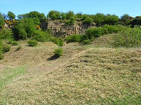 Disused Pittington Quarry, now part of Pittington Hill SSSI |
Site of Special Scientific Interest |
| Location | MAGiC MaP |
|---|
| Nearest city | City of Durham |
|---|
| Coordinates | 54°47′45″N 1°29′15″W |
|---|
| Area | 6.4 ha (16 acres) |
|---|
| Established | 1987 |
|---|
| Governing body | Natural England |
|---|
| Website | Pittington Hill SSSI |
|---|
The hill slopes and former quarry support an extensive area of primary magnesian limestone grassland. Blue moor-grass, Sesleria albicans, a characteristic plant of such grassland, is present but not abundant in the primary grassland on the hill slopes, where herbs such as rock-rose, Helianthemum nummularium, are more common; blue moor-grass is more plentiful in the secondary grassland on the quarry floor and spoil heaps, where it is associated with species such as quaking grass, Briza media, salad burnet, Sanguisorba minor, and autumn gentian, Gentianella amarella.
[1]
References
Sites of Special Scientific Interest in County Durham |
|---|
- Backstone Bank and Baal Hill Woods
- Baldersdale Woodlands
- Bishop Middleham Quarry
- Bollihope, Pikestone, Eggleston and Woodland Fells
- Botany Hill
- Bowes Moor
- Bowlees and Friar House Meadows
- Brasside Pond
- Brignall Banks
- Burnhope Burn
- Butterby Oxbow
- Cassop Vale
- Castle Eden Dene
- Causey Bank Mires
- Charity Land
- Close House Mine
- Cornriggs Meadows
- Cotherstone Moor
- Crag Gill
- Crime Rigg and Sherburn Hill Quarries
- Dabble Bank
- Derwent Gorge and Horsleyhope Ravine
- Durham Coast
- Fairy Holes Cave
- Far High House Meadows
- Fishburn Grassland
- Foster's Hush
- Frog Wood Bog
- God's Bridge
- Grains o' th' Beck Meadows
- Green Croft and Langley Moor
- Greenfoot Quarry
- Hannah's Meadows
- Hawthorn Dene
- Hawthorn Quarry
- Hell Kettles
- Hesledon Moor East
- Hesledon Moor West
- Hexhamshire Moors
- Hisehope Burn Valley
- Hulam Fen
- Hunder Beck Juniper
- Kilmond Scar
- Low Redford Meadows
- Lune Forest
- Mere Beck Meadows
- Middle Crossthwaite
- Middle Side and Stonygill Meadows
- Middleton Quarry
- Middridge Quarry
- Moorhouse and Cross Fell
- Muggleswick, Stanhope and Edmundbyers Commons and Blanchland Moor
- Neasham Fen
- Newton Ketton Meadow
- Old Moss Lead Vein
- Park End Wood
- Pig Hill
- Pike Whin Bog
- Pittington Hill
- Pow Hill Bog
- Quarrington Hill Grasslands
- Railway Stell West
- Raisby Hill Grassland
- Raisby Hill Quarry
- Redcar Field
- Rigg Farm and Stake Hill Meadows
- Rogerley Quarry
- Sherburn Hill
- Shipley and Great Woods
- Sleightholme Beck Gorge – The Troughs
- Slit Woods
- Stony Cut, Cold Hesledon
- Teesdale Allotments
- The Bottoms
- The Carrs
- Thrislington Plantation
- Town Kelloe Bank
- Trimdon Limestone Quarry
- Tuthill Quarry
- Upper Teesdale
- Waldridge Fell
- West Newlandside Meadows
- West Park Meadows
- West Rigg Open Cutting
- Westernhope Burn Wood
- Wingate Quarry
- Witton-le-Wear
- Yoden Village Quarry
|
- Neighbouring areas
- Cleveland
- Northumberland
- Tyne and Wear
|
Текст в блоке "Читать" взят с сайта "Википедия" и доступен по лицензии Creative Commons Attribution-ShareAlike; в отдельных случаях могут действовать дополнительные условия.
Другой контент может иметь иную лицензию. Перед использованием материалов сайта WikiSort.org внимательно изучите правила лицензирования конкретных элементов наполнения сайта.
2019-2026
WikiSort.org - проект по пересортировке и дополнению контента Википедии

