geo.wikisort.org - Mountains
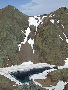
Pic de Sanfonts (Catalan pronunciation: [ˈpiɡ də səmˈfɔns]) is a mountain in the Pyrenees on the border of Spain and northwest Andorra. The nearest town is Arinsal, La Massana.[1] It is a subpeak of, and 1.2 km southwest of, Coma Pedrosa (2942 m), the highest mountain in Andorra.
| Pic de Sanfonts | |
|---|---|
 Pic de Sanfonts (left), Agulla de Baiau (right) and Estany Negre. | |
| Highest point | |
| Elevation | 2,894 m (9,495 ft) |
| Prominence | 150 m (490 ft) |
| Isolation | 1.18 km (0.73 mi) to Coma Pedrosa |
| Coordinates | 42°36′0″N 1°26′43″E |
| Geography | |
 Pic de Sanfonts Location in the Pyrenees | |
| Location | Andorra |
| Parent range | Pyrenees |
References
- Parroquia de la Massana, Comú de la Massana Archived 2013-12-14 at the Wayback Machine. (in Catalan)
На других языках
- [en] Pic de Sanfonts
[fr] Pic de Sanfonts
Le pic de Sanfonts (également pic de Sanfons ou pic de Cenfonts) est un sommet d'Andorre, situé dans la paroisse de La Massana, culminant à une altitude de 2 889[1],[2] ou 2 891[3] mètres.Текст в блоке "Читать" взят с сайта "Википедия" и доступен по лицензии Creative Commons Attribution-ShareAlike; в отдельных случаях могут действовать дополнительные условия.
Другой контент может иметь иную лицензию. Перед использованием материалов сайта WikiSort.org внимательно изучите правила лицензирования конкретных элементов наполнения сайта.
Другой контент может иметь иную лицензию. Перед использованием материалов сайта WikiSort.org внимательно изучите правила лицензирования конкретных элементов наполнения сайта.
2019-2025
WikiSort.org - проект по пересортировке и дополнению контента Википедии
WikiSort.org - проект по пересортировке и дополнению контента Википедии