geo.wikisort.org - Mountains
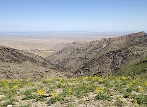
The Nuratau Mountains (Uzbek: Nurota tog'lari, Russian: Нурата́у or Нурати́нский хребе́т) is a mountain range located in Uzbekistan and constitutes one of the western buttresses of the Gissar Range. It borders Aydar Lake to the north, the town of Nurata to the west, the Kyzylkum Desert to the south, and the Sanzar river to the east. Stretching over 170 km in east–west direction it culminates in the 2169 m Mount Zargar.[1]
| Nuratau Mountains | |
|---|---|
 Nuratau mountains and the Sentob valley | |
| Highest point | |
| Elevation | 2,169 m (7,116 ft) |
| Coordinates | 40°30′00.0″N 66°42′00.0″E |
| Naming | |
| Native name | |
| Geography | |
 Location in Uzbekistan | |
| Location | Uzbekistan |
Geology

The range is composed chiefly of sandstone and limestone. It has a flat crest, a steep and rocky northern slope, and a gentle southern slope.[2]
The Nuratau-Kyzylkum Biosphere Reserve
The Nuratau-Kyzylkum Biosphere Reserve (NKBR) was established "to conserve the globally important biodiversity, landscapes and cultural assets of the Nuratau Mountain Range and the adjacent Kyzylkum Desert".[3] The Reserve is said to be the only place in the world where the endangered Severtsov wild sheep (Ovis ammon severtzovi) still roam in the wild.[4] It has also an endemic collection of unique flora and a diverse spread of nut and fruit trees, including strands of pistachio and rare walnut.[5]
References
- Nuratau in the Great Soviet Encyclopedia, 3rd Edition 1970-1979.
- Marie-Franc̦oise Brunet, Tom McCann, Edward R. Sobel: Geological Evolution of Central Asian Basins and the Western Tien Shan Range, 2017, p.442.
- Nuratau-Kyzylkum Biosphere Reserve Retrieved 15 Oktober 2021.
- Key biodiversity of the Reserve Retrieved 15 Oktober 2021.
- Distribution map of Tulips of the Nuratau Mountains and South-Eastern Kyzylkum Retrieved 15 Oktober 2021.
На других языках
- [en] Nuratau Mountains
[fr] Nourataou
Le Nourataou, ou Nourota (en ouzbek : Nurota tog'lari ; en Modèle:Lamg-ru ou Нурати́нский хребе́т), est une chaîne montagneuse d'Ouzbékistan qui fait partie du système montagneux Hissaro-Alaï.[it] Nuratau
Il Nuratau (in uzbeko Нурота тоғлари, Nurota togʻlari; in russo Нурата́у, Nuratau, o Нурати́нский хребе́т, Nuratinskij grebet) è una catena montuosa dell'Asia centrale situata in Uzbekistan; costituisce uno dei contrafforti occidentali del sistema montuoso Gissar-Alai e delimita a sud il deserto del Kyzylkum; ad est la Porta di Tamerlano, attraversata dal Sanzar, ne segna il confine con un'altra catena montuosa, il Malguzar. Si estende su un fronte di 170 km e culmina nei 2169 m del monte Zargar. La catena, costituita prevalentemente da scisto, ha una cresta piuttosto piatta, un versante settentrionale scosceso e roccioso e un versante meridionale più dolce. È suddiviso in più parti da piccoli corsi d'acqua. Le steppe montane di alta quota e quelle arbustive che crescono sulle pendici vengono utilizzate per il pascolo. Nelle valli del versante meridionale vi sono oasi con frutteti, giardini e campi irrigati[1].[ru] Нуратау
Нурата́у, Нурати́нский хребе́т (узб. Nurota tog‘lari, Нурота тоғлари) — горный хребет в Узбекистане, один из западных отрогов Гиссаро-Алайской системы. С юга ограничивает пустыню Кызылкум. На востоке отделяется от хребта Мальгузар глубоким ущельем Тамерлановы Ворота.Другой контент может иметь иную лицензию. Перед использованием материалов сайта WikiSort.org внимательно изучите правила лицензирования конкретных элементов наполнения сайта.
WikiSort.org - проект по пересортировке и дополнению контента Википедии