geo.wikisort.org - Mountains
Hissor Range (Tajik: Қаторкӯҳи Ҳисор, Qatorköhi Hisor; Uzbek: Hisor tizmasi, Russian: Гиссарский хребет; Ukrainian: Ґаторкугі Гісор; also known as Hissar, Hisor, or Gissar Range) is a mountain range in Central Asia, in the western part of the Pamir-Alay system, stretching over 200 km in the general east–west direction across the territory of Tajikistan and Uzbekistan.
| Hissar Range tg. Қаторкӯҳи Ҳисор uz. Hisor tizmasi ru. Гиссарский хребет uk. Ґаторкугі Гісор | |
|---|---|
 View of the Anzob Pass across the Hissar Range with the Zarafshan Range in the background | |
| Highest point | |
| Peak | Khazret Sultan (former Peak of the 22nd Congress of the Communist Party) |
| Elevation | 4,643 m (15,233 ft) |
| Coordinates | 38°55′N 68°15′E |
| Geography | |
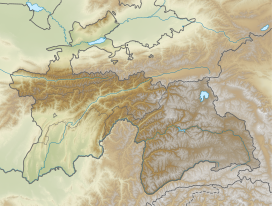
 Location in Tajikistan | |
| Country | Tajikistan, Uzbekistan |
| Parent range | Pamir Mountains |
Geography
The Hissor Range lies south of the Zarafshon Range, extending north of Dushanbe through Tajikistan's Hissar District of the Districts of Republican Subordination and reaching Uzbekistan at the north tip of Surxondaryo Region.[1] The highest point in the Hissar Range at 4,643 meters (15,233 ft) is located in Uzbekistan on the border with Tajikistan, just north-west of Dushanbe. Formerly known as Peak of the 22nd Congress of the Communist Party, the Khazret Sultan is also the highest point in all Uzbekistan. The Hissar Range is composed of crystalline rocks, schist, and sandstone, punctured by granite intrusions.[2]
Nature
Hissor Valley, which encompasses the Shirkent National Park is a 3,000-hectare (7,400-acre) reserve, which is expected to be expanded to some 30,000 ha (74,000 acres) in the coming years, has an unusually high concentration of sites of historical and scientific interest.[3]
See also
- List of mountains in Tajikistan
References
- Atlas of the Soviet Central Asian Republics, Geodesy and Cartography Authority, Moscow, 1988, in Russian.
- Big Soviet Encyclopedia, on-line edition, accessed April 16, 2008.
- Hissar Mountain Range, accessed December 1, 2016.
На других языках
[de] Hissargebirge
Das Hissargebirge, auch Gissargebirge oder Hisorgebirge (usbekisch Hisor tizmasi; tadschikisch Қаторкӯҳи Ҳисор Qatorkuhi Hisor; russisch Гиссарский хребет Gissarski chrebet), ist ein Gebirgszug in Zentralasien.- [en] Gissar Range
[fr] Monts Hissar
Les monts Hissar[1] (également connus comme monts Hisor ou monts Gissar en anglais) sont une chaîne de montagnes d'Asie centrale qui font partie de la zone occidentale du système Pamir–Alaï. Ils s'étendent sur plus de 200 km, orientés grosso modo est-ouest, sur les territoires du Tadjikistan et de l'Ouzbékistan.[it] Gissar
I monti Hisor[1], chiamati anche Gissar, Hisar o Hissar (in tagico Қаторкӯҳи Ҳисор, Qatorkŭhi Hisor; in uzbeco Hisor tizmasi; in russo Гиссарский хребет, Gissarskij chrebet) sono una catena montuosa dell'Asia centrale nella parte occidentale del Pamir-Alaj, che si estendono in Uzbekistan e in Tagikistan. Rappresentano uno spartiacque dei bacini idrografici del fiume Zeravshan e dell'Amu Darya.[2][ru] Гиссарский хребет
Гисса́рский хребе́т — горный хребет в Средней Азии, в западной части Памиро-Алайской горной системы (в Узбекистане и Таджикистане), находится на междуречье бассейнов рек Зеравшан и Амударья.Другой контент может иметь иную лицензию. Перед использованием материалов сайта WikiSort.org внимательно изучите правила лицензирования конкретных элементов наполнения сайта.
WikiSort.org - проект по пересортировке и дополнению контента Википедии
