geo.wikisort.org - Mountains
Mount William (also Mount Duwil) is a mountain of the Grampians Mountain Range, located within the Grampians National Park, in the Australian state of Victoria. The mountain is situated approximately 250 kilometres (160 mi) west-northwest of Melbourne on the eastern edge of the national park, approximately 22 kilometres (14 mi) drive from Halls Gap.
This article needs additional citations for verification. (January 2014) |
| Mount William (Mount Duwil) | |
|---|---|
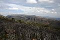
 Looking east from Mount William, towards Ararat | |
| Highest point | |
| Elevation | 1,167 metres (3,829 ft) AHD |
| Coordinates | 37°17′34″S 142°36′3″E |
| Geography | |
 Mt William Location in Victoria | |
| Location | Victoria, Australia |
| Parent range | Grampians |
| Topo map | Geoscience Australia Mount William |
| Climbing | |
| First ascent | Thomas Mitchell (European explorer) |
Features and location
Mount William is the highest point within the Grampians National Park. Sir Thomas Mitchell reached the summit with a group of explorers in 1836. The first settler in the area was Horatio Wills, who established a sheep run at Mount William in 1840, and named nearby Mount Ararat, after which the town is named. His son, cricketer and Australian rules football pioneer Tom Wills, grew up as a lone white child among the Djab wurrung Aboriginal tribes of Mount William.
Three transmission towers are located at the summit of Mount William including an amateur radio repeater. A sealed service road continues to the summit, but is not accessible by vehicle to the general public.
Visitors to the mountain can drive to a carpark located approximately 920 metres (3,020 ft) up the mountain, before proceeding on foot for 1.8 kilometres (1.1 mi) to the summit. It will take a person of moderate fitness approximately 45 mins to walk. No permit is required to climb the mountain.
Gallery
 Western vantage from Mount William
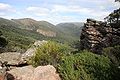 Western vantage from Mount William
 Mount William depicted in Arthur Streeton's 1926 painting Land of the Golden Fleece


Climate
Due to being an exposed peak in the far west of Victoria, Mount William features especially cool maximum temperatures throughout the year. Winter cloud cover is profound; with an extraordinary 26 days of precipitation in July, constituting an annual total of 211—quite possibly the highest figure of any site in mainland Australia. Snowfalls are both frequent and heavy throughout the year.
| Climate data for Grampians (Mount William, 2005–2020); 1,150 m AMSL; 37.30° S, 142.60° E | |||||||||||||
|---|---|---|---|---|---|---|---|---|---|---|---|---|---|
| Month | Jan | Feb | Mar | Apr | May | Jun | Jul | Aug | Sep | Oct | Nov | Dec | Year |
| Record high °C (°F) | 36.6 (97.9) |
36.6 (97.9) |
32.2 (90.0) |
26.1 (79.0) |
18.0 (64.4) |
13.4 (56.1) |
12.1 (53.8) |
16.1 (61.0) |
20.6 (69.1) |
27.0 (80.6) |
32.1 (89.8) |
34.9 (94.8) |
36.6 (97.9) |
| Average high °C (°F) | 21.4 (70.5) |
20.3 (68.5) |
17.7 (63.9) |
12.7 (54.9) |
8.4 (47.1) |
6.3 (43.3) |
4.9 (40.8) |
5.8 (42.4) |
8.8 (47.8) |
12.9 (55.2) |
16.3 (61.3) |
18.4 (65.1) |
12.8 (55.1) |
| Average low °C (°F) | 10.3 (50.5) |
9.7 (49.5) |
8.6 (47.5) |
6.1 (43.0) |
3.7 (38.7) |
2.0 (35.6) |
0.9 (33.6) |
1.0 (33.8) |
2.1 (35.8) |
4.0 (39.2) |
6.6 (43.9) |
7.9 (46.2) |
5.2 (41.4) |
| Record low °C (°F) | 0.9 (33.6) |
1.8 (35.2) |
−0.1 (31.8) |
−1.2 (29.8) |
−2.1 (28.2) |
−2.6 (27.3) |
−4.1 (24.6) |
−2.9 (26.8) |
−3.8 (25.2) |
−3.3 (26.1) |
−2.5 (27.5) |
−0.5 (31.1) |
−4.1 (24.6) |
| Average precipitation mm (inches) | 67.1 (2.64) |
35.0 (1.38) |
53.3 (2.10) |
74.1 (2.92) |
134.6 (5.30) |
123.2 (4.85) |
177.6 (6.99) |
155.3 (6.11) |
116.6 (4.59) |
76.1 (3.00) |
70.2 (2.76) |
66.1 (2.60) |
1,180.6 (46.48) |
| Average precipitation days (≥ 0.2 mm) | 9.2 | 11.2 | 13.6 | 17.3 | 22.4 | 24.4 | 25.9 | 23.5 | 21.0 | 15.9 | 14.6 | 12.4 | 211.4 |
| Source: [1] | |||||||||||||
See also
References
- "Climate statistics for Grampians (Mount William)". Bureau of Meteorology. Retrieved 25 September 2018.
External links
Другой контент может иметь иную лицензию. Перед использованием материалов сайта WikiSort.org внимательно изучите правила лицензирования конкретных элементов наполнения сайта.
WikiSort.org - проект по пересортировке и дополнению контента Википедии