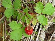
 Fruit of Fragaria iinumae
 Mount Nōgōhaku from Mount Mae
Mount Haku means white mountain.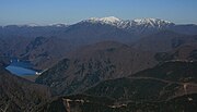 Tokuyama Dam and Mount Nōgōhaku
geo.wikisort.org - Mountains
Mount Nōgōhaku (能郷白山, Nōgōhaku-san) is located on the borders of Gifu and Fukui prefectures in Japan. It is part of the Ryōhaku Mountains and serves as the drainage divide between the Pacific Ocean and the Japan Sea. There is one triangulation station at the top of the mountain.
| Mount Nōgōhaku | |
|---|---|
| 能郷白山 | |
 Mount Nōgōhaku | |
| Highest point | |
| Elevation | 1,617.33 m (5,306.2 ft)[1] |
| Coordinates | 35°45′44″N 136°30′51″E[2] |
| Naming | |
| Language of name | Japanese |
| Geography | |
 Mount Nōgōhaku Location in Japan | |
| Location | Gifu Prefecture Fukui Prefecture Japan |
| Parent range | Ryōhaku Mountains |
| Topo map | Geographical Survey Institute, 25000:1 能郷白山, 50000:1 岐阜 |
| Climbing | |
| First ascent | Taichō in 718 |
Fragaria iinumae was discovered at first in this Mountain and the name Nōgō Fragaria (ノウゴウイチゴ・能郷苺, Nōgō Ichigo) was given.[3][4]
History
- 718: Mountain first climbed by Taichō.
- 1897: Shinto shrine of Mount Nōgōhaku Shrine (能郷白山神社, Nōgōhaku-san Jinja) was reconstructed.
- 1965: A large landslide was created by a major flood in the fall.
Gallery


See also
Wikimedia Commons has media related to Mount Nōgōhaku.
- Ryōhaku Mountains
- Fragaria iinumae
References
- "Information inspection service of the Triangulation station" (in Japanese). Geospatial Information Authority of Japan,(岐阜-能郷白山). Archived from the original on June 9, 2009. Retrieved December 6, 2010.
- "Mountains altitude list in Japan (Gife prefecture)" (in Japanese). Geospatial Information Authority of Japan. Retrieved December 6, 2010.
- Alpine plant in Japan (in Japanese). YAMA-KEI Publishers. 1994. ISBN 4-635-09019-1.
- Alpen guide Mount Haku and mountains in Hokuriku (in Japanese). YAMA-KEI Publishers. 2000. ISBN 4-635-01321-9.
На других языках
- [en] Mount Nōgōhaku
[fr] Mont Nōgōhaku
Le mont Nōgōhaku (能郷白山, Nōgōhaku-san?) se trouve à la limite des préfectures de Gifu et Fukui au Japon. La montagne, qui fait partie des monts Ryōhaku, sert de ligne de partage des eaux entre l'océan Pacifique et la mer du Japon. Une station de triangulation est installée à son sommet.Текст в блоке "Читать" взят с сайта "Википедия" и доступен по лицензии Creative Commons Attribution-ShareAlike; в отдельных случаях могут действовать дополнительные условия.
Другой контент может иметь иную лицензию. Перед использованием материалов сайта WikiSort.org внимательно изучите правила лицензирования конкретных элементов наполнения сайта.
Другой контент может иметь иную лицензию. Перед использованием материалов сайта WikiSort.org внимательно изучите правила лицензирования конкретных элементов наполнения сайта.
2019-2026
WikiSort.org - проект по пересортировке и дополнению контента Википедии
WikiSort.org - проект по пересортировке и дополнению контента Википедии