geo.wikisort.org - Mountains
Mount Nokogiri (鋸岳, Nokogiri-dake) is a mountain located in the Akaishi Mountains on the border between, Yamanashi and Nagano Prefectures in Japan.
| Mount Nokogiri | |
|---|---|
| 鋸岳 | |
 View of Mount Nokogiri from Mount Kaikoma (August 2008) | |
| Highest point | |
| Elevation | 2,685 m (8,809 ft) |
| Listing | List of mountains and hills of Japan by height |
| Coordinates | 35°46′45″N 138°12′36″E |
| Naming | |
| English translation | (wood)saw mountain |
| Language of name | Japanese |
| Geography | |
| Location | Japan |
| Parent range | Akaishi Mountains |
| Topo map | Geographical Survey Institute 25000:1 甲斐駒ヶ岳 50000:1 甲府 |
Outline
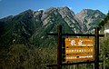
This area is in Minami Alps National Park that was established on June 1, 1964.[1] This mountain is also one of the "200 Famous Japanese Mountains". There is no general mountain climbing trail. Therefore, it is difficult to climb it. There is the shelter Mountain hut ("6th Stone-Hut") between this mountain and Mount Kaikoma. The original hut was rebuilt in 2006.
Geography
Nearby Mountains
It is on the main ridge line in the northern edge of the Akaishi Mountains.
| Image | Mountain | Japanese | Height | Distance from the Top |
Note |
|---|---|---|---|---|---|
 |
Mt. Nokogiri | 鋸岳 | 2,685 m (8,809 ft) | 0 km (0.0 mi) | 200 Famous |
 |
Mt. Kaikoma | 甲斐駒ヶ岳 | 2,967 m (9,734 ft) | 3.4 km (2 mi) | 100 Famous |
 |
Mt. Senjō | 仙丈ヶ岳 | 3,033 m (9,951 ft) | 7.0 km (4.3 mi) | 100 Famous |
River of source
Mount Nokogiri is the source of the Fuji River. The Rivers of the source flow to the Pacific Ocean.
- Fuji River
- Todai River (Tributary of Tenryū River)
Gallery
 Mount Nokogiri from Utajuku
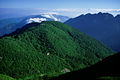 Mount Nokogiri and Uma-no-Se from Mount Ko-Senjō
 Mount Nokogiri from Mount Ko-Senjō
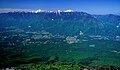


See also
- Akaishi Mountains
- Minami Alps National Park
References
- Minami Alps National Park Archived 2011-03-22 at the Wayback Machine(HP of the Ministry of the Environment)
External links
This article about a location in Yamanashi Prefecture is a stub. You can help Wikipedia by expanding it. |
This Nagano Prefecture location article is a stub. You can help Wikipedia by expanding it. |
На других языках
- [en] Mount Nokogiri (Akaishi)
[fr] Mont Nokogiri (Akaishi)
Le mont Nokogiri (鋸岳, Nokogiri-dake?) est une montagne culminant à 2 685 m d'altitude dans les monts Akaishi à la limite entre les préfectures de Nagano et Yamanashi au Japon. Cette zone est incluse dans le parc national des Alpes du Sud créé le 1er juin 1964[2].Другой контент может иметь иную лицензию. Перед использованием материалов сайта WikiSort.org внимательно изучите правила лицензирования конкретных элементов наполнения сайта.
WikiSort.org - проект по пересортировке и дополнению контента Википедии