geo.wikisort.org - Mountains
Mount Mantalingahan (or Mantalingahan or Mantaling) is the highest mountain in the island province of Palawan in the Philippines, with an elevation of 6,844 ft (2,086 m) above sea level, its ranked 68th-highest peak of an island on Earth and 10th-most prominent mountain in the Philippines. Located in the southern part of Palawan Island that forms the highest part of the Beaufort Mountains Ultramafics geological region, a series of ultramafic outcrops of Eocene origin, of which Mount Victoria forms the largest contiguous land area. The peak of the mountain is the highest point on Palawan island.[3]
| Mount Mantalingajan | |
|---|---|
| Mantalingahan | |
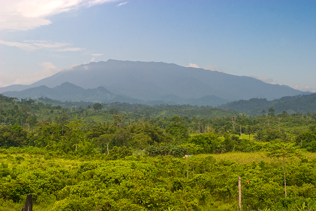 The mountain as seen from Ransang, 4 July 2007 | |
| Highest point | |
| Elevation | 6,844 ft (2,086 m)[1][2] |
| Prominence | 6,844 ft (2,086 m)[1] |
| Listing |
|
| Coordinates | 8°49′06″N 117°40′11″E |
| Geography | |
 Mount Mantalingajan  Mount Mantalingajan Mount Mantalingajan (Philippines) | |
| Country | Philippines |
| Region | Mimaropa |
| Province | Palawan |
| City/municipality | Brooke's Point |
| Parent range | Mantalingahan Range |
The mountain forms the center of the Mount Mantalingahan Protected Landscape (MMPL), a national park covering the entire Mantalingahan Mountain Range. The protected area status of MMPL was proclaimed on June 23, 2009, by virtue of Proclamation No. 1815. The protected area covers an area of 120,457 hectares (1,204.57 km2). The entire park is currently listed as a tentative site for UNESCO World Heritage Site inscription.[2][4]
Continuing discoveries of new species of plant and animal from the mountain highlight its tremendous ecological value and the importance of maintaining such protective zones in the face of constant logging and mining pressures.[2][5][6] The pitcher plant species, Nepenthes mantalingajanensis, described in 2007, is named after the mountain itself.[7] In May 2018, UNESCO formally began the process which would possibly declare the landscape a world heritage site by 2020.[8]
Hiking activity
Mt. Mantalingajan is one of the most difficult climbs in the Philippines, being graded Difficulty 9/9 by local mountaineering website PinoyMountaineer.com. The usual route starts from Barangay Ransang in Rizal on the south-west coast of Palawan. Three days hiking is required to reach the summit and two days to return to the jump-off, a total of five days, unless another day is wanted exploring the summit and surrounds. Highlights of the trail include encounters with the Tau't Bato tribe and the "Knife Edge" Canopy Walk that leads to the summit.[9]
See also
- List of Ultras of the Philippines
- List of protected areas of the Philippines
References
- de Ferranti, Jonathan; Maizlish, Aaron. "Philippine Mountains - 29 Mountain Summits with Prominence of 1,500 meters or greater". Retrieved 2011-01-31.
- "Mt. Mantalingahan Protected Landscape". UNESCO World Heritage Centre. Archived from the original on 17 April 2015. Retrieved 15 May 2019.
- Okubo, Y. 1989. The Mineral Exploration – Mineral Deposits and Tectonics of Two Contrasting Geologic Environments in the Republic of the Philippines – Consolidated Report on Palawan Area. Japan International Cooperation Agency, Metal Mining Agency of Japan and Department of Environment and Natural Resources (Philippines) Joint Committee, 182 p.
- De Los Santos, Melissa. "Palawan's highest peak now a protected area". GMA News. Retrieved 18 August 2010.
- Anda, Redempto D. (21 October 2011). "New species of beetle discovered in Palawan". Philippine Daily Inquirer. Inquirer Southern Luzon. Archived from the original on 24 November 2011. Retrieved 15 May 2019.
- "New species of shrew discovered in Palawan's 'sky island'". ABS-CBN News. 9 May 2018. Archived from the original on 9 May 2018. Retrieved 15 May 2019.
- Nerz, J. & A. Wistuba 2007. Nepenthes mantalingajanensis (Nepenthaceae), eine bemerkenswerte neue Spezies aus Palawan (Philippinen). Das Taublatt 55(3): 17–25.
- https://www.pressreader.com/philippines/palawan-news/20180513/281706910325751 [bare URL]
- Lasco, Gideon (10 March 2008), PinoyMountaineer: Mount Mantalingajan, retrieved 2008-03-28
External links
Другой контент может иметь иную лицензию. Перед использованием материалов сайта WikiSort.org внимательно изучите правила лицензирования конкретных элементов наполнения сайта.
WikiSort.org - проект по пересортировке и дополнению контента Википедии