geo.wikisort.org - Mountains
Mount Lofty (34°58′S 138°42′E, elevation 710 m (2,330 ft) AHD) is the highest point in the southern Mount Lofty Ranges. It is located about 15 km (9.3 mi) east of the Adelaide city centre, within the Cleland National Park in the Adelaide Hills area of South Australia.
| Mount Lofty | |
|---|---|
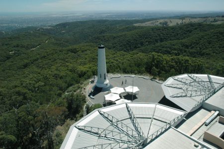 North view of the Summit and Flinders Column from the Fire Tower | |
| Highest point | |
| Elevation | 710 m (2,330 ft) |
| Coordinates | 34°58′S 138°42′E |
| Geography | |
 Mount Lofty Cleland, South Australia, Australia[1] | |
| Parent range | Mount Lofty Ranges |
| Climbing | |
| First ascent | April 1831 Collet Barker (but likely ascended by Indigenous peoples before European contact) |
Mount Lofty Summit has panoramic views of the city and the Adelaide plains to the west, and of the Picadilly Valley to the east. It is also popular destination for international tourists, as well as for cyclists coming up the old Mount Barker Road through Eagle on the Hill, and for walkers from Waterfall Gully.
History

Aboriginal significance
The adjacent peaks of Mount Lofty and Mount Bonython form a prominent landmark visible across the Adelaide Plains, known to the local Kaurna people as Yuridla, 'two-ears', part of the body of an ancestral being called Nganu.[2][3] This Kaurna name has been preserved in its anglicised form as the name of the nearby town of Uraidla.
European discovery and use
Mount Lofty was named by Matthew Flinders on 23 March 1802 during his circumnavigation of the Australian continent.[4] It was first climbed by a European when the explorer Collet Barker climbed it in April 1831, almost six years before Adelaide was settled.
A stone cairn at the summit was originally used to mark the trig point, and in 1885 this was replaced by an obelisk which served as the central reference point for surveying purposes across Adelaide. In 1902 the obelisk was rededicated and renamed as the "Flinders Column".[5]
The Summit was closed to the public during the Second World War, when the obelisk was considered an indispensable navigation aid. A flashing strobe was fitted to the top to improve visibility at night. This strobe was removed after the war, but then re-installed in the 1990s, when the obelisk was repainted and restored during construction of the new kiosk.
Access and description
The summit can be accessed by road from the South Eastern Freeway at Crafers, and from the eastern suburbs via Greenhill Road and the Mount Lofty Scenic Route. The more enthusiastic can walk up the gully from Waterfall Gully, through the Cleland National Park and from Chambers Gully. The track from Waterfall Gully to the summit is a 4 km uphill trek and one of Adelaide's most popular exercise circuits so the carpark at the bottom is often busy. The summit provides panoramic views across Adelaide, and a cafe-restaurant and gift shop. Kangaroos are sometimes spotted on the trails leading up to the summit.
On the ridge near the summit are three television transmission towers (the northernmost being that of the ABC), and the Mount Lofty Fire Tower operated by the Country Fire Service.
Historic houses
Summit Road, Mt Lofty, was one of the best-known addresses in South Australia, with the summer houses of several prominent families being located there. These were all destroyed or severely damaged by the Ash Wednesday bushfires in 1983, but have subsequently been restored.[6] They include:
- Mt Lofty House (1858) - Arthur Hardy[7]
- Eurilla (1884) - William Milne, 1917; Lavington Bonython, 1972; Kym Bonython, 1998[8]
- Carminow (1885) - Thomas Elder,[9] 1905 Langdon Bonython[10]
Other buildings, such as St Michael's House (an Anglican theological college and priory) and "Arthur's Seat", for a time known as Stawell School, a private school for girls, were never rebuilt.[11] Part of this property was excised for the ABC-TV transmitter building and mast.
Note that historically, "Mount Lofty" addresses frequently referred to the area now known as Crafers and to parts of Stirling.
Climate
Snow
Due to Adelaide's mild winters, temperatures cold enough to produce snow in the Adelaide metropolitan area never occur, and the nearest snowfields to Adelaide are in eastern Victoria, over 700 km away. However, light snowfalls (rarely lasting for more than a day) are not uncommon on the summit (although it is possible for Mount Lofty to go two or three years without any snowfall.) This is a huge novelty for the approximately 1.4 million residents of the Adelaide Plains, (particularly for the children), and a photograph of the event has made the front page of the local newspaper many times in the past.[12] Mount Lofty is the coldest location in the Adelaide area; during winter months the temperature may not exceed 3-4 °C on some days. The summit is the most common location for snow in South Australia; rare snowfalls sometimes occur in other parts of the Mount Lofty Ranges, and occasionally further north, in the Flinders and Gammon Ranges.[13]
General and rainfall
Mount Lofty has an oceanic climate (Cfb) in the Köppen climate classification, due to its elevation, and receives a commensurable amount of precipitation during summer to avoid the Mediterranean climate (Cs) classification, since every summer month receives more than 40 millimetres of rainfall. The annual rainfall is nearly twice and the monthly rainfall during summer is more than twice that of the city of Adelaide. The influence of the Mediterranean climate is present with the drying trend during summer.
| Climate data for Mount Lofty (685m ASL) | |||||||||||||
|---|---|---|---|---|---|---|---|---|---|---|---|---|---|
| Month | Jan | Feb | Mar | Apr | May | Jun | Jul | Aug | Sep | Oct | Nov | Dec | Year |
| Record high °C (°F) | 41.1 (106.0) |
38.9 (102.0) |
33.4 (92.1) |
30.5 (86.9) |
24.5 (76.1) |
18.8 (65.8) |
16.9 (62.4) |
24.0 (75.2) |
27.0 (80.6) |
34.3 (93.7) |
37.1 (98.8) |
36.4 (97.5) |
41.1 (106.0) |
| Average high °C (°F) | 22.7 (72.9) |
22.8 (73.0) |
19.9 (67.8) |
16.2 (61.2) |
12.5 (54.5) |
9.6 (49.3) |
8.8 (47.8) |
9.9 (49.8) |
12.6 (54.7) |
15.6 (60.1) |
18.4 (65.1) |
20.4 (68.7) |
15.8 (60.4) |
| Daily mean °C (°F) | 17.6 (63.7) |
17.9 (64.2) |
15.7 (60.3) |
13.0 (55.4) |
10.2 (50.4) |
7.7 (45.9) |
6.9 (44.4) |
7.5 (45.5) |
9.5 (49.1) |
11.6 (52.9) |
13.8 (56.8) |
15.6 (60.1) |
12.3 (54.1) |
| Average low °C (°F) | 12.4 (54.3) |
12.9 (55.2) |
11.4 (52.5) |
9.8 (49.6) |
7.9 (46.2) |
5.7 (42.3) |
4.9 (40.8) |
5.1 (41.2) |
6.3 (43.3) |
7.6 (45.7) |
9.3 (48.7) |
10.8 (51.4) |
8.7 (47.7) |
| Record low °C (°F) | 4.5 (40.1) |
4.4 (39.9) |
3.8 (38.8) |
1.1 (34.0) |
−0.4 (31.3) |
0.1 (32.2) |
−0.1 (31.8) |
−0.5 (31.1) |
0.6 (33.1) |
0.4 (32.7) |
1.6 (34.9) |
3.0 (37.4) |
−0.5 (31.1) |
| Average rainfall mm (inches) | 40.6 (1.60) |
42.2 (1.66) |
54.7 (2.15) |
62.4 (2.46) |
124.7 (4.91) |
140.5 (5.53) |
173.9 (6.85) |
131.3 (5.17) |
123.8 (4.87) |
59.9 (2.36) |
39.6 (1.56) |
55.0 (2.17) |
1,047.3 (41.23) |
| Average rainy days | 7.1 | 7.6 | 9.9 | 13.8 | 16.3 | 21.5 | 23.8 | 21.6 | 19.0 | 12.3 | 9.8 | 10.9 | 173.6 |
| Average relative humidity (%) (at 3pm) | 51 | 50 | 56 | 60 | 73 | 82 | 80 | 72 | 70 | 64 | 58 | 53 | 64 |
| Source: [14] | |||||||||||||
Gallery
 Snow at Eurilla in 1905
 View SE across the Piccadilly Valley from the Mount Lofty Scenic Route. The summit of Mount Barker, 22 km away, is visible on the horizon.
 Flinders Column dedication plaque, from 1902
 View of Adelaide Plains at night from the summit.
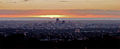 View of the eastern suburbs, the Adelaide city centre and the Gulf St Vincent at sunset from the summit.


See also
References
- "Search result for 'Mount Lofty, MT' with the following datasets selected - 'Suburbs and Localities' and 'Gazetteer'". Location SA Map Viewer. Government of South Australia. Retrieved 26 December 2018.
- Amery, Rob; Buckskin, Vincent (Jack) Kanya (March 2009). "Chapter 10. Pinning down Kaurna names: Linguistic issues arising in the development of the Kaurna Placenames Database" (PDF). In Hercus, Luise; Hodges, Flavia; Simpson, Jane (eds.). The Land is a Map: Placenames of Indigenous Origin in Australia. ANU Press. pp. 187–212. ISBN 978-1921536571.
- James Tylor on the power of language, InDaily, 12 September 2018. Retrieved 5 July 2021.
- Flinders, Matthew (1966) [1814]. A Voyage to Terra Australis : undertaken for the purpose of completing the discovery of that vast country, and prosecuted in the years 1801, 1802, and 1803 in His Majesty's ship the Investigator, and subsequently in the armed vessel Porpoise and Cumberland Schooner; with an account of the shipwreck of the Porpoise, arrival of the Cumberland at Mauritius, and imprisonment of the commander during six years and a half in that island (Facsimile ed.). Adelaide: Libraries Board of South Australia. p. 251. Retrieved 4 January 2014.
- Smith, Pam; Pate, F. Donald; Martin, Robert (2006). Valleys of Stone: The Archaeology and History of Adelaide's Hills Face. Belair, South Australia: Kōpi Books. p. 232. ISBN 0 975 7359-6-9.
- Wall, Barbara (2008). Mount Lofty Summit Road: A survey 1841-2008 (research paper).
- "Explore Mt Lofty House". Mt Lofty House - Adelaide Hills - Grand Mercure. Archived from the original on 25 August 2013. Retrieved 6 May 2013. History Archived 2016-07-06 at the Wayback Machine
- Amanda Ward (February 2008). "Eurilla rises again". SA Life Magazine, vol. 5, no. 2. pp. 32–43. Archived from the original on 11 April 2013. Retrieved 17 June 2012.
Keelan, Michael (February 2008). "Eurilla : for the love of trees". SA Life Magazine, vol. 5, no. 2. pp. 44–51. Archived from the original on 11 April 2013. Retrieved 17 June 2012.
Photos: 1890,1890,1905,1983[permanent dead link]. See also: ,"Archived copy". Archived from the original on 22 March 2012. Retrieved 16 June 2012.{{cite web}}: CS1 maint: archived copy as title (link),"Archived copy" (PDF). Archived from the original (PDF) on 20 May 2009. Retrieved 16 June 2012.{{cite web}}: CS1 maint: archived copy as title (link) - Fayette Gosse. Elder, Sir Thomas (1818–1897). Australian Dictionary of Biography, National Centre of Biography, Australian National University. Retrieved 6 May 2013.
- A Trip to Mount Lofty, 31 March 1906, The Advertiser pg.6
- Barbara Wall A Short History of Stawell School: The forgotten school on Mount Lofty published for Mount Lofty Districts Historical Society by Peacock Publications 2012 ISBN 978--1-921601-69-9
- Advertiser coverage of "Snow at Mt Lofty": 1 August 2014; 22 July 2013; 11 October 2012.
- "Heaviest Snowfall in S.A. History". The Advertiser (Adelaide). South Australia. 19 July 1949. p. 1. Retrieved 22 September 2019 – via National Library of Australia.
- "Climate statistics for Australian locations". www.bom.gov.au. Retrieved 24 January 2018.
External links
На других языках
- [en] Mount Lofty
[es] Monte Lofty
El Monte Lofty es el punto más alto de los Montes Lofty. Se localiza a 15 km al este del centro de la ciudad de Adelaida en Australia Meridional y ofrece hermosos panoramas de la ciudad de Adelaida y las colinas. Fue por primera vez escalada por un europeo en 1831, casi siete años antes de que Adelaida empezara a ser colonizada. Fue nombrado por Matthew Flinders por su circunnavegación de Australia en 1802.[fr] Mont Lofty
Le mont Lofty (727 mètres) est le point culminant de la chaîne du Mont-Lofty, à l'est d'Adélaïde en Australie-Méridionale.[ru] Лофти (гора)
Гора Лофти (высота 727 м) самая высокая точка хребта Маунт-Лофти к востоку от Аделаиды в Южной Австралии. Это первая гора в регионе, на которую взошли европейцы, когда исследователь Коллет Баркер совершил восхождение в 1831 году, почти через 7 лет после заселения Аделаиды. Название гора получила от Мэтью Флиндерса во время его путешествия вокруг Австралии в 1802.Другой контент может иметь иную лицензию. Перед использованием материалов сайта WikiSort.org внимательно изучите правила лицензирования конкретных элементов наполнения сайта.
WikiSort.org - проект по пересортировке и дополнению контента Википедии