geo.wikisort.org - Mountains
Mount Liamuiga is a 3,792-foot (1,156 m) stratovolcano which forms the western part of the island of Saint Kitts. The peak is the highest point on the island of Saint Kitts, in the federation of Saint Kitts and Nevis, and in the entire British Leeward Islands, as well as one of the tallest peaks in the eastern Caribbean archipelago. The peak is topped by a 0.6-mile (1 km) wide summit crater, which contained a shallow crater lake until 1959. As of 2006, the crater lake had re-formed.[1] The last verified eruptions from the volcano were about 1,800 years ago, while reports of possible eruptions in 1692 and 1843 are considered uncertain.
| Mount Liamuiga | |
|---|---|
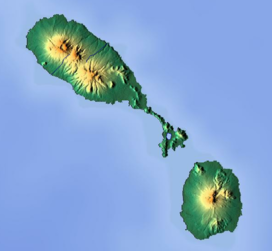 Mount Liamuiga Location in Saint Kitts and Nevis | |
| Highest point | |
| Elevation | 3,792 ft (1,156 m) |
| Prominence | 3,792 ft (1,156 m) |
| Listing |
|
| Coordinates | 17°22′N 62°48′W |
| Geography | |
| Location | Saint Kitts |
| Geology | |
| Mountain type | Stratovolcano |
| Last eruption | 160 CE ± 200 years |
Mount Liamuiga was formerly named Mount Misery. The renaming took place on the date of St. Kitts' independence, September 19, 1983. However, many older citizens still refer to it as Mount Misery. The name Liamuiga is derived from the Kalinago name for the entire island of St. Kitts, which means, "fertile land."
The mountainsides are covered in farmland and small villages up to the 1,500-foot (460 m) height, after which lush tropical rainforests drape the slopes until cloud forest takes over at 3,000 ft (900 m). Many tours and guided hikes are organized to the peak's summit and surrounding rainforests, usually starting from Belmont Estate in the village of St. Paul's. From the summit, the views are outstanding, including the entire island and the beautiful Caribbean Sea, as well as the neighbouring islands of Saba, Sint Eustatius, Saint Barthélemy, Saint Martin, Antigua, and Nevis.
See also
References
- "Liamuiga". Global Volcanism Program. Smithsonian Institution.
- University of the West Indies - Seismic Research Unit: St. Kitts Volcanism (extensive info, photos, and geological maps)
- Braun, Morton R. (1990-11-18). "Climbing a St. Kitts Volcano". The New York Times. Retrieved 2007-05-06.
- Avery, Roberta (2006-12-21). "Trek to top of 'Mount Misery' is a picnic – even in the rain". Toronto Star. Retrieved 2007-05-06.
External links
- "Mount Liamuiga". Peakware.com. Archived from the original on 2016-03-04.
На других языках
[de] Mount Liamuiga
Der Mount Liamuiga (auch: Mount Misery) ist ein 1156 m hoher Stratovulkan auf der karibischen Insel St. Kitts.- [en] Mount Liamuiga
[fr] Mont Liamuiga
Le mont Liamuiga, anciennement mont Misery, en anglais Mount Liamuiga et Mount Misery, est un stratovolcan de Saint-Christophe-et-Niévès situé dans la partie ouest de l'île de Saint-Christophe. Avec 1 156 mètres d'altitude, il constitue le point culminant de l'île et du pays.Другой контент может иметь иную лицензию. Перед использованием материалов сайта WikiSort.org внимательно изучите правила лицензирования конкретных элементов наполнения сайта.
WikiSort.org - проект по пересортировке и дополнению контента Википедии