geo.wikisort.org - Mountains
Mount Houghton is a 10,490-foot-elevation mountain summit located in Washoe County, Nevada, United States.
| Mount Houghton | |
|---|---|
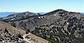
 Northeast aspect, from Mt. Rose | |
| Highest point | |
| Elevation | 10,490 ft (3,200 m)[1][2] |
| Prominence | 759 ft (231 m)[3] |
| Parent peak | Mount Rose (10,776 ft)[4] |
| Isolation | 1.34 mi (2.16 km)[4] |
| Coordinates | 39°20′03″N 119°56′22″W[5] |
| Naming | |
| Etymology | John G. Houghton |
| Geography | |
 Mount Houghton Location in Nevada  Mount Houghton Mount Houghton (the United States) | |
| Location | Mount Rose Wilderness |
| Country | United States of America |
| State | Nevada |
| County | Washoe |
| Parent range | Sierra Nevada Carson Range |
| Topo map | USGS Mount Rose |
| Climbing | |
| Easiest route | class 1 hiking[4] |
Description
Mount Houghton is set seven miles north of Lake Tahoe in the Mount Rose Wilderness, on land managed by the Humboldt-Toiyabe National Forest. It is the highest point of Relay Ridge, second-highest peak within the wilderness, and ranks as the seventh-highest peak of the Carson Range,[3] which is a subset of the Sierra Nevada. It is situated 1.4 miles (2.3 km) north of Relay Peak, 1.4 miles (2.3 km) southwest of line parent Mount Rose and six miles (10 km) north of Incline Village. Topographic relief is significant as the west aspect rises 2,000 feet (610 meters) above Gray Creek in one mile. The Tahoe Rim Trail traverses the southern base of the peak, providing an approach option.
Etymology
This landform's toponym was officially adopted in 1988 by the U.S. Board on Geographic Names to remember Dr. John Greenleaf Houghton (1940–1979), professor of geography at the University of Nevada, Reno.[5] He was one of 257 people who perished November 29, 1979, when Air New Zealand Flight 901 flew into Mount Erebus on Ross Island, Antarctica, killing all 237 passengers and 20 crew on board.[6]
Climate
According to the Köppen climate classification system, Mount Houghton is located in an alpine climate zone.[7] Most weather fronts originate in the Pacific Ocean, and travel east toward the Sierra Nevada mountains. As fronts approach, they are forced upward by the peaks (orographic lift), causing them to drop their moisture in the form of rain or snowfall onto the range. Most of the snow in Nevada falls from December through March.[8]
See also
- List of Lake Tahoe peaks
 Mountains portal
Gallery
 Mt. Houghton (right) and Relay Peak (left) viewed from Mt. Rose Trail
 Mt. Houghton (left), Mt. Rose (right)
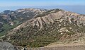 Mt. Houghton (right) and Relay Peak (left) viewed from Mt. Rose
 Mt. Houghton and north ridge


References
- United States Board on Geographic Names (1988), Decisions on Geographic Names in the United States, List 8803, Department of the Interior, p. 9
- United States Geological Survey topographical map - Mount Rose
- "Mount Houghton, Nevada". Peakbagger.com. Retrieved 2022-07-23.
- "Houghton, Mount - 10,490' NV". listsofjohn.com. Retrieved 2022-07-23.
- "Mount Houghton". Geographic Names Information System. United States Geological Survey, United States Department of the Interior. Retrieved 2022-07-23.
- John Houghton, otago.ac.nz
- "Climate of the Sierra Nevada". Encyclopædia Britannica.
- John G. Houghton (1975), Nevada's Weather and Climate, Nevada Bureau of Mines and Geology, University of Nevada, p. 53
External links
- Weather forecast: Mount Houghton
- John G. Houghton: Wikidata
Другой контент может иметь иную лицензию. Перед использованием материалов сайта WikiSort.org внимательно изучите правила лицензирования конкретных элементов наполнения сайта.
WikiSort.org - проект по пересортировке и дополнению контента Википедии