geo.wikisort.org - Mountains
Mount Goode is a 13,085-foot-elevation (3,988 meter) mountain summit located on the crest of the Sierra Nevada mountain range in California, United States.[2] It is situated on the shared boundary of Kings Canyon National Park with John Muir Wilderness, and along the common border of Fresno County with Inyo County. It is also approximately one mile west-northwest of Bishop Pass, one mile east-southeast of Mount Johnson, 1.23 miles (1.98 km) south of Hurd Peak, and 16 miles (26 km) west of the community of Big Pine.
| Mount Goode | |
|---|---|
 North aspect, from Long Lake | |
| Highest point | |
| Elevation | 13,085 ft (3,988 m)[1] |
| Prominence | 845 ft (258 m)[1] |
| Parent peak | Mount Gilbert[1] |
| Isolation | 1.62 mi (2.61 km)[1] |
| Listing | Sierra Peaks Section |
| Coordinates | 37°07′23″N 118°34′05″W[2] |
| Naming | |
| Etymology | Richard Urquhart Goode |
| Geography | |
 Mount Goode  Mount Goode | |
| Location | Fresno / Inyo counties California, U.S. |
| Parent range | Sierra Nevada[1] |
| Topo map | USGS North Palisade |
| Geology | |
| Type of rock | granite |
| Climbing | |
| First ascent | July 16, 1939 by Chester Versteeg[3] |
| Easiest route | class 2[3] |
History
This mountain's name and location were officially adopted in 1926 by the U.S. Board on Geographic Names based on a recommendation by the Sierra Club.[2] Prior to 1926, the USGS placed Mount Goode at the location of Black Giant. The name commemorates Richard Urquhart Goode (1858–1903), geographer for the United States Geological Survey, in charge of the Pacific Division, Topographic Branch.[4] The first ascent of the peak was made July 16, 1939, by Chester Versteeg, a prominent Sierra Club member.
Climbing
Established rock climbing routes on Mount Goode:[5]
| Route | Class | Pitches | First Ascent |
|---|---|---|---|
| Southeast Slope | 2 | 1939 | |
| West Ridge | 5.4 | ||
| No Goode | 5.4 | 3 | |
| North Buttress | 5.9 | 9 | 1974 |
| Goode Earth | 5.10 | 6 | |
| Sky Pilot | 5.11 | 6 | 2014 |
Climate
According to the Köppen climate classification system, Mount Goode is located in an alpine climate zone.[6] Most weather fronts originate in the Pacific Ocean, and travel east toward the Sierra Nevada mountains. As fronts approach, they are forced upward by the peaks, causing them to drop their moisture in the form of rain or snowfall onto the range (orographic lift). Precipitation runoff from this mountain drains west into the Kings River, and east to Owens River via Bishop Creek.
Gallery
 North Face of Goode
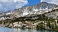
 Mt. Goode from the end of Long Lake
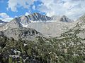
 Goode's non-technical southeast slope (left) seen from Bishop Pass.
(Bishop Lake centered and Saddlerock Lake to right) Goode's southeast slope seen from Bishop Pass
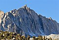
 North aspect


See also
References
- "Mount Goode, California". Peakbagger.com. Retrieved 2021-04-06.
- "Mount Goode". Geographic Names Information System. United States Geological Survey. Retrieved 2021-04-06.
- Secor, R.J. (2009). The High Sierra Peaks, Passes, and Trails (3rd ed.). Seattle: The Mountaineers. p. 223. ISBN 978-0898869712.
- Moynier, John; Fiddler, Claude (1993). Sierra Classics 100 Best Climbs in the High Sierra. Chockstone Press. p. 150. ISBN 978-0934641609.
- "Mt. Goode Rock Climbing". Mountain Project. Retrieved 2021-11-21.
- Peel, M. C.; Finlayson, B. L.; McMahon, T. A. (2007). "Updated world map of the Köppen−Geiger climate classification". Hydrol. Earth Syst. Sci. 1. ISSN 1027-5606.
External links
- Weather forecast: Mount Goode
- Mt. Goode photo: Flickr
Другой контент может иметь иную лицензию. Перед использованием материалов сайта WikiSort.org внимательно изучите правила лицензирования конкретных элементов наполнения сайта.
WikiSort.org - проект по пересортировке и дополнению контента Википедии