geo.wikisort.org - Mountains
Mount Gimie is the tallest mountain on the island of Saint Lucia. It is located in the Canries District on the west side of Saint Lucia. The mountain's peak reaches 950 m (3,120 ft). It is covered by lush tropical rainforest and was formed as the result of intense volcanic activity 200,000 to 300,000 years ago. Mount Gimie is still volcanic and so are many other of the Pitons (a couple of volcanic plugs in which Mount Gimie belongs).[1][2][3]
| Mount Gimie | |
|---|---|
 Mount Gimie as seen from Gros Piton | |
| Highest point | |
| Elevation | 950 m (3,120 ft)[1] |
| Prominence | 950 m (3,120 ft)[1] |
| Listing | Country high point |
| Coordinates | 13°51′48″N 61°00′40″W[2] |
| Geography | |
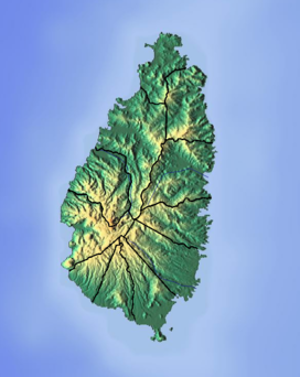 Mount Gimie Location in Saint Lucia | |
| Location | Canaries District, Saint Lucia |
References
- "Mount Gimie, Saint Lucia". Peakbagger.com. Retrieved December 20, 2011.
- "Mount Gimie". National Geospatial Intelligence Agency. Retrieved August 8, 2021.
- "Mount Gimie". GeoNames. Retrieved August 15, 2021.
Saint Lucia articles | |||||
|---|---|---|---|---|---|
| History |
|  | |||
| Geography |
| ||||
| Politics |
| ||||
| Economy |
| ||||
| Society |
| ||||
| |||||
This Saint Lucia location article is a stub. You can help Wikipedia by expanding it. |
На других языках
[de] Mount Gimie
Der Mount Gimie ist mit 950 Metern der höchste Berg auf der karibischen Insel St. Lucia. Der Berg ist vulkanischen Ursprungs und wird von üppigem tropischen Regenwald umgeben. Die Besteigung ist nur mit einem vom Ministry of Agriculture, Forestry and Fisheries, Forestry Department (MAFFFD) lizenzierten Führer erlaubt.[1]- [en] Mount Gimie
[es] Monte Gimie
El monte Gimie se ubica en la parte central de la isla de Santa Lucía, un pequeño país localizado al sur de la Martinica y al norte de Venezuela, Trinidad y Tobago y San Vicente y las Granadinas, en aguas del mar Caribe. Con una altura de 950 metros sobre el nivel del mar es considerado el pico más alto de esa nación. Sus coordenadas son 13° 51' de latitud norte y 61° 0' de longitud en dirección oeste, muy cerca de la Reserva Forestal Edmund y de las Cataratas Enbas Saut, al este de Soufriere.[fr] Mont Gimie
Le mont Gimie est la plus haute montagne de Sainte-Lucie. Elle culmine à 950 m d'altitude. D'origine volcanique, elle est entièrement recouverte d'une forêt tropicale abondante. Son ascension n'est autorisée qu'accompagné d'un guide local reconnu par le Ministère de l'Agriculture (MAFFFD).Текст в блоке "Читать" взят с сайта "Википедия" и доступен по лицензии Creative Commons Attribution-ShareAlike; в отдельных случаях могут действовать дополнительные условия.
Другой контент может иметь иную лицензию. Перед использованием материалов сайта WikiSort.org внимательно изучите правила лицензирования конкретных элементов наполнения сайта.
Другой контент может иметь иную лицензию. Перед использованием материалов сайта WikiSort.org внимательно изучите правила лицензирования конкретных элементов наполнения сайта.
2019-2026
WikiSort.org - проект по пересортировке и дополнению контента Википедии
WikiSort.org - проект по пересортировке и дополнению контента Википедии