geo.wikisort.org - Mountains
Mount Gayley is a 13,510-foot-elevation (4,118 meter) mountain summit located one mile east of the crest of the Sierra Nevada mountain range in Inyo County, California, United States.[3] It is situated in the Palisades area of the John Muir Wilderness, on land managed by Inyo National Forest. It is approximately 13 miles (21 km) west-southwest of the community of Big Pine, 0.67 miles (1.08 km) southwest of Temple Crag, and 0.5 miles (0.80 km) north-northeast of parent Mount Sill. Mount Gayley ranks as the 59th highest summit in California.[2]
| Mount Gayley | |
|---|---|
 Southwest aspect | |
| Highest point | |
| Elevation | 13,516 ft (4,120 m)[1] |
| Prominence | 430 ft (130 m)[1] |
| Parent peak | Mount Sill[2] |
| Coordinates | 37°06′11″N 118°29′59″W[3] |
| Naming | |
| Etymology | Charles Mills Gayley |
| Geography | |
 Mount Gayley  Mount Gayley | |
| Location | Inyo County, California, U.S. |
| Parent range | Sierra Nevada[1] |
| Topo map | USGS Split Mountain |
| Climbing | |
| First ascent | 1927 by Norman Clyde[4] |
| Easiest route | Exposed scramble, class 3[2] |
History
The name commemorates Charles Mills Gayley (1858–1932), beloved English professor and Academic Dean of the University of California, Berkeley.[5] This mountain's name was officially adopted prior to 1939 by the U.S. Board on Geographic Names based on a recommendation by the Sierra Club.[6] Mount Sill and nearby Mount Jepson were also named for University of California professors. The first ascent of the summit was made June 10, 1927, by Norman Clyde, who is credited with 130 first ascents, most of which were in the Sierra Nevada.[7]
Climbing
Established climbing routes on Mount Gayley:[8]
- Southwest Ridge (aka Yellow Brick Road) – class 3 – First ascent 1927
- South Face – class 3 – Several possible routes
- West Face – class 3 – FA June 1950 by Robert Cogburn and Ed Robbins
Access from Big Pine: Glacier Lodge Road, North Fork Big Pine Creek Trail, then Glacier Trail.
Climate
According to the Köppen climate classification system, Mount Gayley is located in an alpine climate zone.[9] Most weather fronts originate in the Pacific Ocean, and travel east toward the Sierra Nevada mountains. As fronts approach, they are forced upward by the peaks, causing them to drop their moisture in the form of rain or snowfall onto the range (orographic lift). This climate supports the Palisade Glacier below the west slope. Precipitation runoff from this mountain drains into Big Pine Creek.
Gallery
 Mt. Gayley from the west
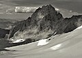 In 1984, with Palisade Glacier
 Mt. Gayley (centered} above Palisade Glacier as seen from North Palisade.
"Buck Mountain" (aka Contact Peak) beyond Gayley.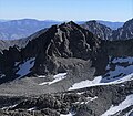 Mt. Gayley from the west
 Gayley from the north. (Mt. Sill to right)
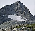
 Mount Gayley (centered) seen from Temple Crag, with Mt. Sill behind (left).


See also
 Mountains portal
- List of the major 4000-meter summits of California
References
- "Mount Gayley, California". Peakbagger.com. Retrieved 2021-04-18.
- "Gayley, Mount". ListsOfJohn.com.
- "Mount Gayley". Geographic Names Information System. United States Geological Survey. Retrieved 2021-04-18.
- Secor, R.J. (1992). The High Sierra Peaks, Passes, and Trails (1st ed.). Seattle: The Mountaineers. p. 187. ISBN 978-0898863130.
- Erwin Gustav Gudde, William Bright, California Place Names: The Origin and Etymology of Current Geographical Names, 1998, University of California Press, ISBN 9780520213166, page 142.
- Ann Lage, Chronicle of the University of California, 2000, page 96.
- Norman Clyde - Mountaineer, Owensvalleyhistory.com
- Alan M. Hedden and David R. Brower, A Climber's Guide to the High Sierra (1954)
- Peel, M. C.; Finlayson, B. L.; McMahon, T. A. (2007). "Updated world map of the Köppen−Geiger climate classification". Hydrol. Earth Syst. Sci. 11. ISSN 1027-5606.
External links
- Weather forecast: Mount Gayley
- Mt. Gayley Rock Climbing: Mountainproject.com
- Mt. Gayley: Mountain-Forecast.com
Другой контент может иметь иную лицензию. Перед использованием материалов сайта WikiSort.org внимательно изучите правила лицензирования конкретных элементов наполнения сайта.
WikiSort.org - проект по пересортировке и дополнению контента Википедии