geo.wikisort.org - Mountains
Mount Cameroon is an active volcano in the South West region of Cameroon next to the city of Buea near the Gulf of Guinea. Mount Cameroon is also known as Cameroon Mountain or Fako (the name of the higher of its two peaks) or by its indigenous name Mongo ma Ndemi ("Mountain of Greatness"). It is the highest point in sub-Saharan western and central Africa,[5] the fourth-most prominent peak in Africa, and the 31st-most prominent in the world. The mountain is part of the area of volcanic activity known as the Cameroon Volcanic Line, which also includes Lake Nyos, the site of a disaster in 1986. The most recent eruption occurred on February 3, 2012.
| Mount Cameroon | |
|---|---|
 Mount Cameroon from Buea | |
| Highest point | |
| Elevation | 4,040 m (13,250 ft)[1][2] |
| Prominence | 3,901 m (12,799 ft)[3] Ranked 31st |
| Isolation | 2,338 km (1,453 mi) |
| Listing | Country high point Ultra |
| Coordinates | 4°13′00″N 9°10′21″E |
| Naming | |
| Native name | Mongo ma Ndemi (Duala) |
| Geography | |
 Mount Cameroon Cameroon | |
| Location | Southwest Region, Cameroon |
| Geology | |
| Mountain type | Stratovolcano |
| Last eruption | February 2012 |
| Climbing | |
| First ascent | Joseph Merrick, 1840s[4] |
| Easiest route | Scramble |
Description
Mount Cameroon is one of Africa's largest volcanoes, rising to 4,040 metres (13,255 ft) above the coast of west Cameroon.[6] It rises from the coast through tropical rainforest to a bare summit, which is cold, windy, and occasionally dusted with snow. The massive steep-sided volcano of dominantly basaltic-to-trachybasaltic composition forms a volcanic horst constructed above a basement of Precambrian metamorphic rocks covered with Cretaceous to Quaternary sediments. More than 100 small cinder cones, often fissure-controlled parallel to the long axis of the massive 1,400-cubic-kilometre (336 cu mi) volcano, occur on the flanks and surrounding lowlands. A large satellitic peak, Etinde (also known as Little Mount Cameroon), is located on the southern flank near the coast. Mount Cameroon has the most frequent eruptions of any West African volcano. The first written account of volcanic activity could be the one from the Carthaginian Hanno the Navigator, who may have observed the mountain in the 5th century BC. Moderate explosive and effusive eruptions have occurred throughout history from both summit and flank vents. A 1922 eruption on the southwestern flank produced a lava flow that reached the Atlantic coast. A lava flow from a 1999 south-flank eruption stopped 200 m (660 ft) from the sea, cutting the coastal highway.
Flora
The mountain's natural vegetation varies with elevation. The main plant communities on the mountain include:[7]
- Lowland rain forest predominates on the lower slopes, from sea level to 800 meters elevation. The lowland forests are part of the Cross-Sanaga-Bioko coastal forests ecoregion. They are composed of evergreen trees with a dense canopy 25 to 30 meters high, with taller emergent trees rising above the canopy. Many trees have buttress roots. The forests are diverse and species-rich, with numerous lianas. Much of the lowland forest has been converted to agriculture and agroforestry, including oil palm plantations.
- Lower montane forest, also known as submontane forest or cloud forest, grows between 800 and 1,600 meters elevation. The lower montane forests are composed of evergreen trees, which form a 20 – 25 meter-high canopy that is either closed or discontinuous. There are scattered areas of meadow and scrubland, with grasses, herbs, tall herbaceous plants (including Acanthaceae), tree ferns, woody shrubs, and low trees. Frequent clouds and mists sustain profuse epiphytes, including mosses, ferns, and orchids. The lower montane forests are diverse and species-rich, with characteristic Afromontane plants and endemic species. Impatiens etindensis[8] and I. grandisepala[9] are herbaceous epiphytes endemic to the montane forests of Mount Cameroon. The lower montane forests, together with the higher-elevation forests, scrub, and grasslands, are part of the Mount Cameroon and Bioko montane forests ecoregion.
- Upper montane forest grows from 1,600 – 1,800 meters elevation. Trees up to 20 meters high form an open-canopied forest with numerous epiphytes. The upper montane forests are less species-rich than the lower-elevation forests, and fires are more frequent.
- Montane scrub grows between 1,800 and 2,400 meters elevation. Low trees of 1 to 15 meters form open-canopied forests, woodlands, and shrublands, with an understory of small shrubs, herbs, ferns, and climbers.
- Montane grassland occurs between 2,000 and 3,000 meters elevation. The dominant vegetation is tussock grasses, with scattered fire-tolerant shrubs and low trees.
- Sub-alpine grassland is found at the highest elevations, from 3,000 to over 4,000 meters. Frost-tolerant tussock grasses, dwarf trees and shrubs, and crustose, foliose, and fruticose lichens predominate.[7]
Fauna and flora
Large mammals on the mountain include the African forest elephant (Loxodonta cyclotis), with a population of over 100 individuals. Other herbivores include red river hog (Potamochoerus porcus), bushbuck (Tragelaphus scriptus), bay duiker (Cephalophus dorsalis), blue duiker (Philantomba monticola), and yellow-backed duiker (Cephalophus sylvicultor). The mountain is home to several species of primates, including chimpanzee (Pan troglodytes), drill (Mandrillus leucophaeus), red-capped mangabey (Cercocebos torquatus), putty-nosed monkey (Cercopithecus nictitans), mona monkey (Cercopithecus mona), red-eared monkey (Cercopithecus erythrotis), Preuss’ guenon (Cercopithecus preussii), and crowned guenon (Cercopithecus pogonias).[7]
Two species of birds are endemic to Mount Cameroon, Mount Cameroon spurfowl (Pternistis camerunensis) and Mount Cameroon speirops (Zosterops melanocephalus).[7]
Flora
 A view of the tropical rain forest on the mountain
 Mahogany
 Disamara tree
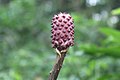 Arum plant
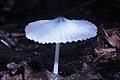 Agaricus mushroom
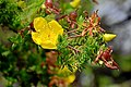 Wild flower
 Stinkhorn mushroom


Mount Cameroon National Park

Mount Cameroon National Park (Parc National du Mont Cameroun) was created in 2009. It covers an area of 581.23 km².[10] The park includes the former Etinde Forest Reserve and most of the Bomboko Forest Reserve.[11] A portion of the Bomboko Forest Reserve remains outside the park, on the lower northern slopes of the mountain.[7]
Access
The peak is frequently ascended by hikers. The annual Mount Cameroon Race of Hope scales the peak in around 4½ hours. Sarah Etonge has won the race seven times and is also a tour operator. English explorer Mary Kingsley, one of the first Europeans to scale the mountain, recounts her expedition in her 1897 memoir Travels in West Africa.
Gallery
 Mount Fako, left view
 Top view at Mount Fako
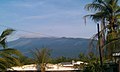 Mount Fako
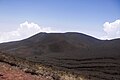 Summit at mount Cameroon
 Landscape of Mount Cameroon
 View of the mountain from the base
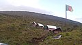 Accommodation facilities on Mount Fako
 Ditto
Ditto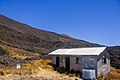 Ditto
Ditto- Cameroon Mountain Race
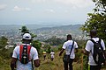 Hikers climbing down
 View of Mount Etinde
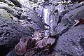 Mount Cameroon tropical rocks
 Limbe Beach
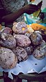 Burning Plum


See also
- Debundscha
- List of volcanoes in Cameroon
Notes
- A higher elevation of 4,095 m (13,435 ft) is often given, but this is not compatible with SRTM data, which shows no 3" cells higher than 4,027 m (13,212 ft) or 1" cells higher than 4,029 m (13,219 ft).
- A hand-held GPS reading of 4,045 m (13,271 ft) was reported in 2015. The elevation is subject to change due to volcanic activity.
- "Mont Cameroun, Cameroon" Peakbagger.com. Retrieved 2012-09-30.
- DeLancey and DeLancey 174. The authors do not give a precise year, but Merrick was active in Cameroon from 1844 to 1849.
- "Mount Cameroon", Encyclopedia Britannica
- Geiger, Harri; Barker, Abigail K.; Troll, Valentin R. (2016-10-07). "Locating the depth of magma supply for volcanic eruptions, insights from Mt. Cameroon". Scientific Reports. 6 (1): 33629. Bibcode:2016NatSR...633629G. doi:10.1038/srep33629. ISSN 2045-2322. PMC 5054387. PMID 27713494.
- The Management Plan of the Mount Cameroon National Park and its Peripheral Zone, 2015 - 2019. The Ministry of Forestry and Wildlife, Republic of Cameroon.
- Cheek, M. (2014). "Impatiens etindensis". IUCN Red List of Threatened Species. 2014: e.T39501A2927828. doi:10.2305/IUCN.UK.2014-3.RLTS.T39501A2927828.en. Retrieved 18 November 2021.
- Cheek, M. (2014). "Impatiens grandisepala". IUCN Red List of Threatened Species. 2014: e.T39500A2927763. doi:10.2305/IUCN.UK.2014-3.RLTS.T39500A2927763.en. Retrieved 18 November 2021.
- "Mont Cameroun". Protected Planet. Accessed 15 June 2020
- Martin, Alex ed. (2012) Interactive Forest Atlas of Cameroon, Version 3.0. Overview Report. World Resources Institute. ISBN 978-1-56973-789-7.
References
- DeLancey, M. W. and M. D. DeLancey. (2000). Historical Dictionary of the Republic of Cameroon (3rd ed.). Lanham, Maryland: The Scarecrow Press.
- "Cameroon". Global Volcanism Program. Smithsonian Institution. Retrieved 2009-01-14.
External links
На других языках
[de] Kamerunberg
Der Kamerunberg (auch Fako, früher Albertspitze; engl. Mount Cameroon, frz. Mont Cameroun) ist ein aktiver Vulkan im Westen von Kamerun. Er ist 4095 m[1][2] hoch und damit der höchste Berg Westafrikas. Er liegt in der Region South-West, im englischsprachigen Teil des Landes, in unmittelbarer Nähe zur Küste genau an der Beugung des Golfs von Guinea und somit im Bereich des ungefähren Überganges zwischen West- und Zentralafrika.- [en] Mount Cameroon
[es] Monte Camerún
El monte Camerún, conocido también como monte Fako —el nombre del más elevado de sus dos picos— o en una lengua nativa, Mongo ma Ndemi (Montaña de la Grandiosidad) es un volcán activo del Camerún, cerca del golfo de Guinea. Forma parte del área de vulcanismo conocida como cordillera de Camerún, que incluye el lago Nyos, escenario de la tragedia del Lago Nyos de 1986. Las erupciones más recientes del monte Camerún ocurrieron el 28 de marzo de 1999 y el 28 de mayo de 2000.[fr] Mont Cameroun
Le mont Cameroun est un volcan du Cameroun, point culminant de la ligne du Cameroun et de l'Afrique de l'Ouest avec, selon les estimations, 4 040, 4 070 ou 4 095 mètres d'altitude. Volcan actif, ses éruptions peu explosives de nature hawaïenne ou strombolienne se traduisent par l'ouverture de fissures volcaniques qui émettent des coulées de lave.[it] Monte Camerun
Il monte Camerun è un vulcano del Camerun situato vicino al golfo di Guinea.[ru] Камерун (вулкан)
Камеру́н — активный вулкан, располагающийся на территории департамента Фако Юго-Западного региона Республики Камерун, в районе Гвинейского залива. Также известен под названием Фако (высший из двух пиков вулкана), местные жители вулкан называют Монго ма Ндеми (Mongo ma Ndemi). Высота вулкана составляет 4100 метров[2][источник не указан 1211 дней], что делает его самой высокой вершиной Камеруна. В 2000 году произошло крупное извержение.Другой контент может иметь иную лицензию. Перед использованием материалов сайта WikiSort.org внимательно изучите правила лицензирования конкретных элементов наполнения сайта.
WikiSort.org - проект по пересортировке и дополнению контента Википедии