geo.wikisort.org - Mountains
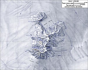
Mount Andrus is a shield volcano 3.2 km (2 mi) SE of Mount Boennighausen in the SE extremity of Ames Range, in Marie Byrd Land, Antarctica. Mapped by USGS from surveys and U.S. Navy air photos, 1964–68. Named by US-ACAN for Lt. Carl H. Andrus, US Navy, medical officer and Officer-in-Charge of Byrd Station in 1964.[1]
| Mount Andrus | |
|---|---|
 Aerial view of the Ames Range. Mount Andrus is the first mount from the left, excluding Mount Berlin, which can be seen isolated far away | |
| Highest point | |
| Elevation | 2,978 m (9,770 ft) |
| Coordinates | 75°48′0″S 132°18′0″W |
| Geography | |
| Parent range | Ames Range |
| Geology | |
| Age of rock | middle Miocene - Holocene |
| Mountain type | Shield volcano |
| Volcanic field | Marie Byrd Land Volcanic Province |
| Last eruption | Unknown |
Andrus has a 4.5 km-wide caldera at its summit.[1] The westward face of the mountain is drained by the Coleman Glacier, with significant crevassing present. While the age of Mt. Andrus is not well known it is one of the oldest trachytic shield volcanoes in Marie Byrd Land, similar in age to Mount Hampton.[1]

See also
References
- Le Masurier, W. E. (1990). "B. 12. Ames Range". In Le Masurier, W. E.; Thomson, J.W. (eds.). Volcanoes of the Antarctic Plate and Southern Oceans. Antarctic Research Series vol 48. Washington, DC: American Geophysical Union. pp. 216–220. doi:10.1029/AR048. ISBN 9781118664728.
- "Andrus". Global Volcanism Program. Smithsonian Institution.
External links
- https://web.archive.org/web/20051030114935/http://usarc.usgs.gov/antarctic_atlas/
- http://www.skimountaineer.com/
На других языках
[de] Mount Andrus
Mount Andrus ist ein 2978 m hoher erloschener Schildvulkan im Marie-Byrd-Land in Westantarktika.- [en] Mount Andrus
[fr] Mont Andrus
Le mont Andrus est un volcan de l'Antarctique.[ru] Андрус (вулкан)
Андрус — щитовой вулкан высотой 2978 метров, расположенный в Антарктиде в районе Земли Мэри Бэрд. Состоит из трёх слившихся щитовых вулканов площадью 252 км³. Сложен трахитами. Гора Андрус является наиболее молодой и была активная в эпоху позднего плейстоцена-голоцена. Образует 4,5-километровую кальдеру. Слабая фумарольная активность наблюдалась на горе Кауффман в 1977 году, которая находится недалеко от Андруса.Текст в блоке "Читать" взят с сайта "Википедия" и доступен по лицензии Creative Commons Attribution-ShareAlike; в отдельных случаях могут действовать дополнительные условия.
Другой контент может иметь иную лицензию. Перед использованием материалов сайта WikiSort.org внимательно изучите правила лицензирования конкретных элементов наполнения сайта.
Другой контент может иметь иную лицензию. Перед использованием материалов сайта WikiSort.org внимательно изучите правила лицензирования конкретных элементов наполнения сайта.
2019-2025
WikiSort.org - проект по пересортировке и дополнению контента Википедии
WikiSort.org - проект по пересортировке и дополнению контента Википедии
