geo.wikisort.org - Mountains
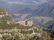
Morro da Igreja (Portuguese pronunciation: [ˈmoʁu dɐ iˈɡɾeʒɐ] "Hill of the Church") is a peak situated in Urubici, a municipality of the Santa Catarina state, in southern Brazil. Its latitude is 28º07'31" S and its longitude is 49º29'38" W, with an elevation of 1,822 metres (5,977 feet), the highest inhabited point and the second most elevated of this state.
| Morro da Igreja | |
|---|---|
 The summit | |
| Highest point | |
| Elevation | 1,822 m (5,978 ft) |
| Coordinates | 28°07′30″S 49°28′28″W |
| Naming | |
| English translation | Hill of the Church |
| Language of name | Portuguese |
| Pronunciation | Portuguese: [ˈmoʁu dɐ iˈɡɾeʒɐ] |
| Geography | |
| Location | Urubici, state of Santa Catarina, Brazil |
| Parent range | Serra Geral |
| Climbing | |
| Easiest route | By car from Urubici on the road SC 439. |
This peak registered the lowest (unofficial) temperature in Brazil: -17.8 °C (0 °F), on June 29, 1996.[1][2] It is considered the coldest place in this country; tourism is popular in the winter, when snowfalls can occur.
Officially, there is a 1,810 meter weather station by Epagri/Ciram[3] the record low was registered on August 21, 2020, by a 2 centimeter snowy cold snap. It was a -8.6°C (17°F) windy and CAVOK morning, with a high of -1.2°C (30°F) in the afternoon, actually the second lowest high. The absolute 24-hour lowest high ever registered is -2.3°C (28°F), on July 23, 2013, same day of the former record low of -7.8°C (18°F). [4][5]


The Brazilian Air Force has a military base on the summit equipped with radars and radio relays for air traffic control (CINDACTA) of the Brazilian Southern Region.
There is a curious natural formation in this area, called Pedra Furada (literally Drilled Stone), and it can be spotted from the peak.
See also
- Morro da Boa Vista, the highest peak of Santa Catarina.
- Serra do Rio do Rastro
References
- (in Portuguese) Sibéria brasileira no sul do Brasil ("Brazilian Siberia in the South of Brazil"), Fantástico, July 18, 2006.
- "Morro da Igreja". SummitPost.org. Retrieved 2014-05-24.
- (in Portuguese) Epagri/Ciram - Agroconnect website
- OGIMET - Morro da Igreja, August 21, 2020.
- "Morro da Igreja". SummitPost.org. Retrieved 2014-05-24.
External links
- (in Portuguese) Portal of Morro da Igreja
На других языках
- [en] Morro da Igreja
[es] Morro da Igreja
Morro da Igreja (español: Cerro de la Iglesia - IPA: ['moʁu dɘ i'gɾeʒɘ]) es una montaña ubicada en la Región Sur de Brasil, en el sudeste del estado de Santa Catarina, en la Serra Geral, municipio de Urubici. Situada a 1822 msnm, es la segunda montaña más alta del estado (la más alta es Morro de Boa Vista, también situada en Urubici, con 1.827 msnm) y es el punto habitado más alto de la Región Sur, donde fue registrada la temperatura más baja de Brasil: -17,8 °C, el 29 de junio de 1996.[1] Con la ocurrencia de vientos fuertes, la sensación térmica fue -46 °C. Hasta esta fecha, la temperatura más baja en territorio brasileño había sido registrada en el municipio de Caçador, en el mismo estado, durante el invierno de 1975, con -14 °C. En su cumbre están una base militar de la FAB (Força Aérea Brasileira) y las antenas de control del tráfico aéreo del sur de Brasil (CINDACTA).[fr] Morro da Igreja
Le Morro da Igreja (« Mont de l'Église », en français) est situé au sud-est de l'État brésilien de Santa Catarina, dans la chaîne de la Serra Geral, sur le territoire du la municipalité d'Urubici. Son altitude est de 1 822 mètres.Другой контент может иметь иную лицензию. Перед использованием материалов сайта WikiSort.org внимательно изучите правила лицензирования конкретных элементов наполнения сайта.
WikiSort.org - проект по пересортировке и дополнению контента Википедии
