geo.wikisort.org - Mountains
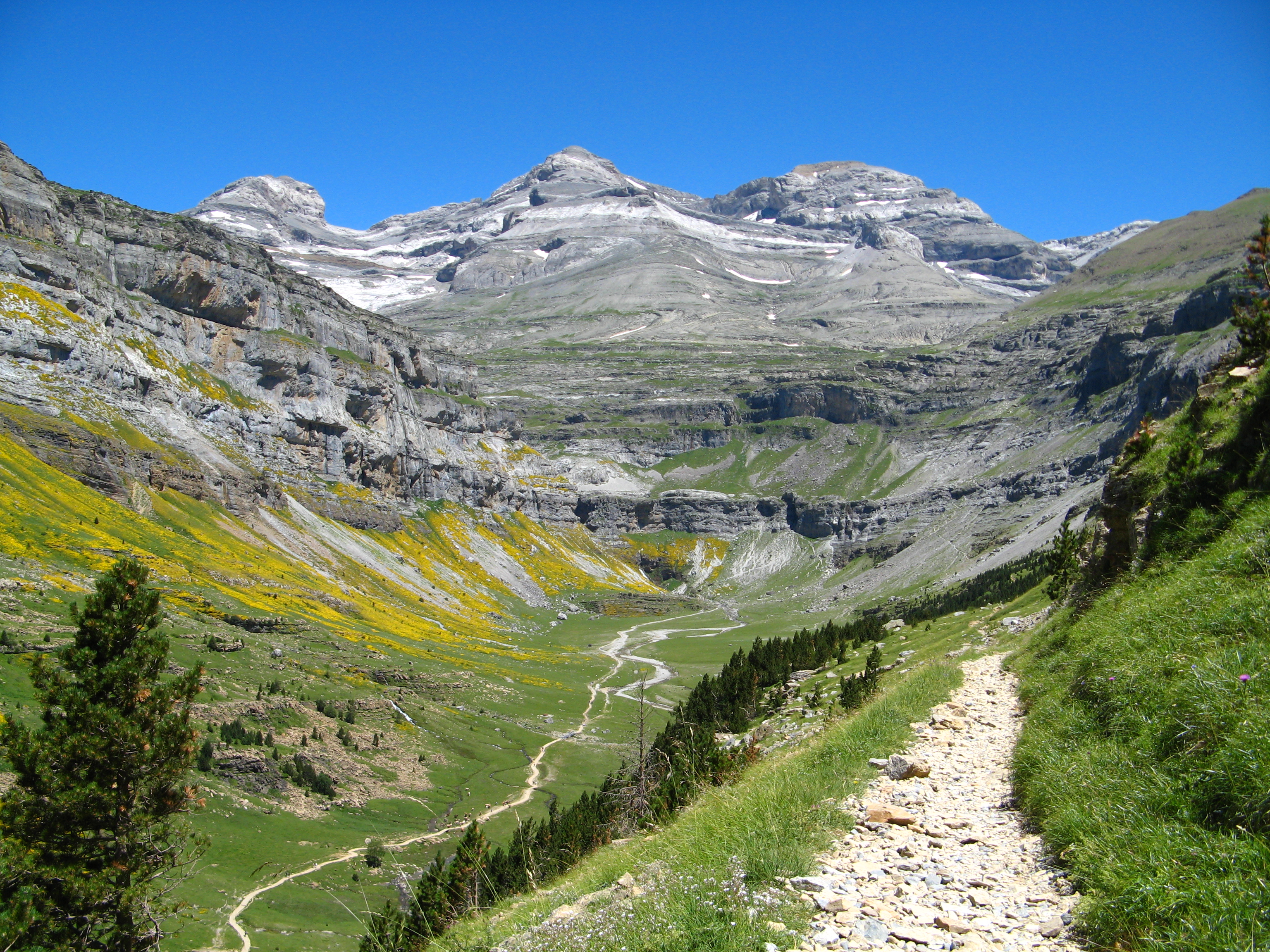
Monte Perdido (in Spanish; Mont Perdu in French; Mont Perdito in Aragonese;all four meaning lost mountain) is the third highest mountain in the Pyrenees. The summit of Monte Perdido (3355 m), located in Spain, lies hidden from France by the seemingly impenetrable peaks of the Cirques of Gavarnie and Estaubé. It stands in the north of Huesca province. The mountain forms part of the Monte Perdido Range and is located in the Ordesa y Monte Perdido National Park, in the western part of the Pyrenees, in the community of Aragon, Spain.
| Monte Perdido | |
|---|---|
 Monte Perdido (center) and Cilindro de Marboré (left) | |
| Highest point | |
| Elevation | 3,355 m (11,007 ft) |
| Prominence | 969 m (3,179 ft) |
| Coordinates | 42°40′N 0°02′E |
| Naming | |
| English translation | Lost mountain |
| Language of name | Spanish |
| Geography | |
 Monte Perdido Pyrenees | |
| Location | Ordesa Valley, Huesca Province, Aragon, Spain |
| Parent range | Pyrenees |
UNESCO World Heritage Site | |
| Official name | Pyrénées - Mont Perdu |
| Type | Mixed |
| Criteria | iii, iv, v, vii, viii |
| Designated | 1997 (21st session) |
| Reference no. | 773 |
| Region | Europe and North America |
| Extensions | 1999 |
Description
Monte Perdido Glacier, locating on the north-facing slope of Monte Perdido, is the third largest glacier in the Pyrenees. It is surrounded by vertical cliffs up to 800m in height.[1] Similar to most European glaciers, the Monte Perdido Glacier has been shrinking since the Little Ice Age, and since 1981, the glacier has lost 48 hectares of surface area.[1] The rate of retreat is continuing to accelarate due to the effects of global climate change.
Access to the mountain is easier from Spain than from France. The route starts near the village of Torla, Aragon, at the Ordesa Valley and ascends the Cirque de Soaso towards the Refuge of Góriz before the stiff climb to the summit. It is a dangerous climb with snow.
National park
Monte Perdido is the centrepiece of the Spanish Ordesa y Monte Perdido National Park which was established in 1918 with just 21 square kilometres/hectares of land. In the 1970s work began to build a dam in the nearby Añisclo Canyon with the objetive of creating hydroelectric energy but institutions and citizens demonstrated against this and suceeded in stopping it. In 1982 the park was expanded significantly to 156 square kilometres/hectares and now incorporates the whole of the Añisclo Canyon.[2] There are more than 1,500 species of flowers, 171 species of birds, 32 different mammals and 8 types of reptile in the Ordesa. Among these is the lammergeier (bearded vulture) with a 3-metre wingspan. The Pyrenees is one of the few places in Europe where these birds can be seen.
Because of its imposing landforms, the national park was inscribed on the UNESCO World Heritage List in 1997 as part of the Pyrénées – Mont Perdu World Heritage Site.[3]
See also
References
- López-Moreno, Juan Ignacio; Revuelto, Jesús; Rico, Ibai; Chueca-Cía, Javier; Julián, Asunción; Serreta, Alfredo; Serrano, Enrique; Vicente-Serrano, Sergio Martín; Azorin-Molina, Cesar; Alonso-González, Esteban; García-Ruiz, José María (17 March 2016). "Thinning of the Monte Perdido Glacier in the Spanish Pyrenees since 1981". The Cryosphere. 10 (2): 681–694. doi:10.5194/tc-10-681-2016.
- "Parque Nacional Ordesa y Monte Perdido. Historia". Ordesa y Monte Perdido. Retrieved 14 December 2020.
- "Pyrénées - Mont Perdu". UNESCO World Heritage Centre. United Nations Educational, Scientific, and Cultural Organization. Retrieved 24 October 2021.
External links
- (in Spanish) Normal route and Escaleras route to climb Monte Perdido komandokroketa.org, retrieved 2013-08-20
- (in English) "Glaciar de Monte Perdido - Gavarnie and Monte Perdido Massif" swisseduc.ch, retrieved 2013-08-20
World Heritage Sites in France | ||
|---|---|---|
| Île-de-France |
| |
| Parisian basin |
| |
| Nord-Pas-de-Calais |
| |
| East |
| |
| West |
| |
| South West |
| |
| Centre East |
| |
| Mediterranean |
| |
| Multiple regions |
| |
| Overseas departments and territories |
| |
| ||
World Heritage Sites in Spain | ||
|---|---|---|
For official site names, see each article or the List of World Heritage Sites in Spain. | ||
| North West |
|  |
| North East |
| |
| Centre |
| |
| East |
| |
| South | ||
| Balearic Islands |
| |
| Canary Islands |
| |
| ||
Authority control | |
|---|---|
| General |
|
| National libraries | |
This article about a location in Aragon, Spain, is a stub. You can help Wikipedia by expanding it. |
На других языках
[de] Monte Perdido
Der Monte Perdido (franz. Mont Perdu), der Verlorene Berg ist mit einer Höhe von 3355 Metern der dritthöchste Berg in den Pyrenäen. Er liegt in der Gemeinde Fanlo der spanischen Provinz Huesca, im Norden von Aragón im Nationalpark Ordesa y Monte Perdido, knapp südlich der Grenze zu Frankreich. Am Fuß des Berges entspringen die Flüsse Arazas und Cinca. Das sich über die Grenze beider Länder erstreckende Bergmassiv ist seit 1997 als UNESCO-Welterbe ausgezeichnet.- [en] Monte Perdido
[fr] Mont Perdu
Le mont Perdu[2] (Monte Perdido en espagnol, Punta de Treserols en aragonais, ce qui signifie « la pointe des Trois Sœurs » en français), situé en Espagne, proche de la frontière franco-espagnole, est le sommet le plus élevé du massif du Mont-Perdu avec 3 348 m d'altitude[1], sur la crête séparant les canyons d'Ordesa et de Pineta (ou Pinède). C'est le pic central des Tres Serols (en aragonais) ou Tres Hermanas (en espagnol) constituées par le cylindre du Marboré, le soum de Ramond, et le mont Perdu lui-même.[it] Monte Perdido
Il Monte Perdido (chiamato Mont Perdu in francese, Punta de Treserols in aragonese e Monte Perduto in italiano) è la terza vetta più alta dei Pirenei.[ru] Монте-Пердидо
Мо́нте-Перди́до (исп. Monte Perdido или Мон-Пердю́ (фр. Mont Perdu, оба названия означают «потерянная гора») — третья по высоте горная вершина в Пиренеях (после пика Ането и Посетса), находится на севере испанской провинции Уэска близ границы с французским департаментом Пиренеи Верхние. Высота 3355 м, рядом расположены вершины Сирк-де-Гаварни (Cirque de Gavarnie) и Сирк-д-Эстобе (Cirque d’Estaubé). Гора входит в состав национального парка Ордеса-и-Монте-Пердидо, расположенного в западных Пиренеях. На западном склоне горы берёт начало река Синка, относящаяся к бассейну реки Эбро.Другой контент может иметь иную лицензию. Перед использованием материалов сайта WikiSort.org внимательно изучите правила лицензирования конкретных элементов наполнения сайта.
WikiSort.org - проект по пересортировке и дополнению контента Википедии