geo.wikisort.org - Mountains
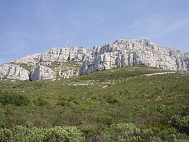
Mont Puget is a mountain, part of Marseille-Cassis calanques, located south-east of Marseille. Like most Marseille mountains, it is formed from limestone.
| Mont Puget | |
|---|---|
 Mont Puget from the Luminy University campus | |
| Highest point | |
| Elevation | 563 m (1,847 ft) |
| Coordinates | 43°13′19″N 05°27′31″E |
| Geography | |
| Location | Bouches-du-Rhône, France |
| Parent range | Calanques de Marseille |
| Geology | |
| Mountain type | Limestone |
Tourism

Often neglected by tourists, much interested by the Calanques themselves and by the sea, the Mont Puget can provide for some interesting hiking and climbing.
A very good trail leads to the very top of the mountain (like on most of Marseille mountain ranges, so that firefighters can get everywhere should a fire start).
However, one can also climb the mountain directly, which can provide many interesting experiences.
One of them are "stone rivers", or collections of numerous small stones "flowing" from the mountain at angles reaching 45 degrees.
The top of the mountain is covered with eroded limestone that sticks out in numerous needle-like spikes.
Crest of Luminy University
A stylized representation of Mont Puget is displayed on the crest of Luminy Faculty of Sciences, part of the University of the Mediterranean Aix-Marseille II. The Luminy campus is located 1 km northwest of Mont Puget.
Name
An urban legend insist that the mountain is named after the sculptor Pierre Puget which is a curious misconception since the mountain's name predates the sculptor on maps by several millennia. The name Puget is a diminutive from the Provençal word "puech" that originates from the Latin "podium", hence an elevated place that designates a certain eminence.
References
- Marseille Tourism Office Information
- French Nationan Geographic Institute maps (for altitude figure)
External links
- Le massif des Calanques
- A satellite view of Mont Puget the city and the university campus are on the left, the road at the top is Marseille-Cassis road (the Gineste).
На других языках
[de] Mont Puget
Der Mont Puget ist ein 565 Meter – nach anderer Quelle ein 564 Meter[1] – hoher Berg im Département Bouches-du-Rhône der Region Provence-Alpes-Côte d’Azur in Frankreich.[2] Er liegt östlich von Marseille und vom Massif de Marseilleveyre und ist der höchste Punkt der Calanques[3].- [en] Mont Puget
[fr] Mont Puget
Le mont Puget est le point culminant du massif des Calanques avec 563 mètres d'altitude, dans le département français des Bouches-du-Rhône. Il est situé dans le sud-est du territoire de Marseille, entre le cap Croisette à l'ouest et Cassis à l'est. Il offre une vue unique sur les rades nord et sud de la ville de Marseille.[it] Monte Puget
Il Monte Puget è la cima più elevata del massiccio dei Calanchi situato a sud-est di Marsiglia, tra Cap Croisette a ovest e Cassis a est.Другой контент может иметь иную лицензию. Перед использованием материалов сайта WikiSort.org внимательно изучите правила лицензирования конкретных элементов наполнения сайта.
WikiSort.org - проект по пересортировке и дополнению контента Википедии
